1932 Poole Bros. Bird's Eye Views of Lake George and Lake Champlain, New York
LakeGeorgeChamplain-poole-1932$350.00

Title
Lake George Lake Champlain.
1932 (dated) 18 x 32 in (45.72 x 81.28 cm)
1932 (dated) 18 x 32 in (45.72 x 81.28 cm)
Description
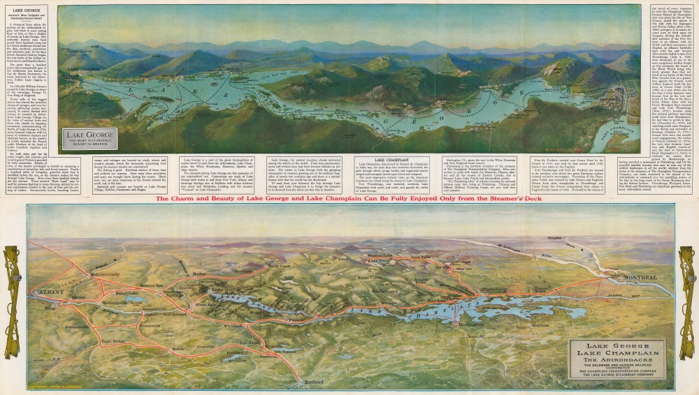
Featuring two views on one sheet, this is a 1932 Poole Brothers view map of Lake George and Lake Champlain, New York. It was issued to promote the Lake George Steamboat Company and the Champlain Transportation Company, and thus highlight natural beauty and transportation.
A Closer Look
A view of Lake George occupies the upper quadrants. Depicting from Prospect Mountain and the town of Lake George to Ticonderoga and Lake Champlain, lines illustrate the routes of the Lake George Steamboat company. Towns served by the steamboat are labeled, along with bays, points, and islands. This view is framed on three sides by text providing a history of both Lake George and Lake Champlain as well as advice to travelers. The lower view encompasses both Lake George and Lake Champlain covering from Albany to Montreal. Highways and railroads are named, as are many Adirondack lakes and mountains.Verso Content
The verso provides tourists with a wealth of information, including steamboat schedules, ferry prices, general information about both companies, and a diagram of the steamers operated by the Champlain Transportation Company. Smaller maps of Lake George and Lake Champlain appear as well, along with information concerning hotels.Publication History and Census
This piece was created and published by Poole Brothers in 1932 and distributed by the Champlain Transportation Company and the Lake George Steamboat Company with two views copyrighted by M. J. Powers in 1927 occupying the recto. Powers appears to have created at least one of these from a view drawn by H. H. Green and published in 1911 by A. A. Heard. Poole Brothers published editions as early as 1926, but we have been unable to find any cataloged examples of the present 1932 edition.Cartographer
Poole Brothers (1878 - 1968) were a Chicago based firm active in the late 19th and early 20th century with an initial focus on promotional railroad maps. Poole Brothers was founded by George Amos Poole (March 20, 1843 – September 7, 1918). In 1868, Poole, along with his uncle William H. Rand (1828 - 1915) and Andrew McNally (1836 - 1904), purchased the Chicago Tribune's job printing plant and formed the firm Rand McNally. In 1878, he left Rand McNally to form, with his brother William H. Poole, Poole Brothers, a direct competitor to Rand McNally for the lucrative railroad business. Like many of its competitors, Poole Brothers maintained an office on Chicago's Printer's Row (downtown Loop district). Their earliest known work is an 1880 map of Yellowstone National Park. In 1887, Poole Brothers, Andrew McNally, and several others formed the United Typothetae of America, a master printers association. In 1848, they were cited, along with Rand McNally and George Cram, by the Federal Trade Commission for price fixing. Their earliest known work is an 1880 map of Yellowstone National Park. Afterward they went on to produce a vast range of maps and other print products including tickets, cards, coupons, and restaurant menus. In time Poole Brothers merged with Newman-Randolph, which was then acquired by the American Can Company in the early 1960s. The American Can Company liquidated its printing concerns later in the same decade. More by this mapmaker...
Condition
Good. Wear along original fold lines. Verso repairs to fold intersections. Slight loss at a few fold intersections.