
This item below is out of stock, but another example (left) is available. To view the available item, click "Details."
Details
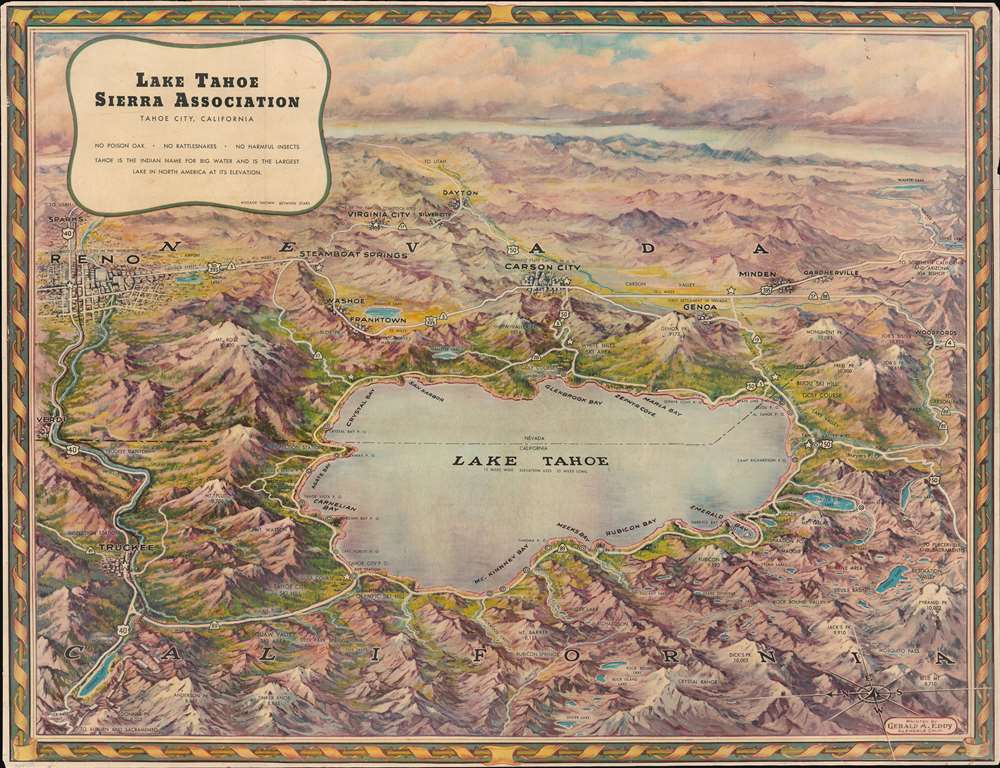
1950 Eddy Bird's Eye View Map of Lake Tahoe
$450.00
1950 Eddy Bird's Eye View Map of Lake Tahoe
LakeTahoe-eddy-1950$225.00

Title
Lake Tahoe.
1950 (undated) 17.5 x 22.75 in (44.45 x 57.785 cm)
1950 (undated) 17.5 x 22.75 in (44.45 x 57.785 cm)
Description
This is a gorgeous c. 1950 Gerald A. Eddy bird's-eye view map of Lake Tahoe. Situated astride the border between California and Nevada, Lake Tahoe dominates the foreground. Bays, harbors, and towns along its banks beckon to the weary Los Angeleno or other city dwellers, calling to them as sirens call to sailors. Ski resorts, mountain peaks, numerous smaller lakes, and other natural features contribute to the area's welcoming aura. Reno, Carson City, and Truckee all are labeled, along with many other towns.
Publication History and Census
This view was created by Gerald A. Eddy and published by the Lake Tahoe Sierra Association c. 1950. An example is cataloged in OCLC and is part of the collection at the University of California - Berkeley.Cartographer
Gerald Allen Eddy (October 12, 1889 - September 9, 1967) was an American artist. Born in Michigan, Eddy's parents either divorced or his father died between 1900 and 1910. In 1910 Eddy was living with his mother, brother, and stepfather in Los Angeles and working as an artist. Eddy was a prolific cartographer and created numerous maps of different areas of the western United States. He was married and had a daughter by 1917, according to his World War I draft card. He was married to his wife Madolyn when he died. More by this mapmaker...
Condition
Very good. Laid down on archival tissue. Backmatter suggests the margins were trimmed, but all recto contest present.
References
OCLC 26485199.