This item has been sold, but you can get on the Waitlist to be notified if another example becomes available, or purchase a digital scan.
1945 Dolph Map of Lake Worth, Florida
LakeWorthFL-dolph-1945$175.00


Title
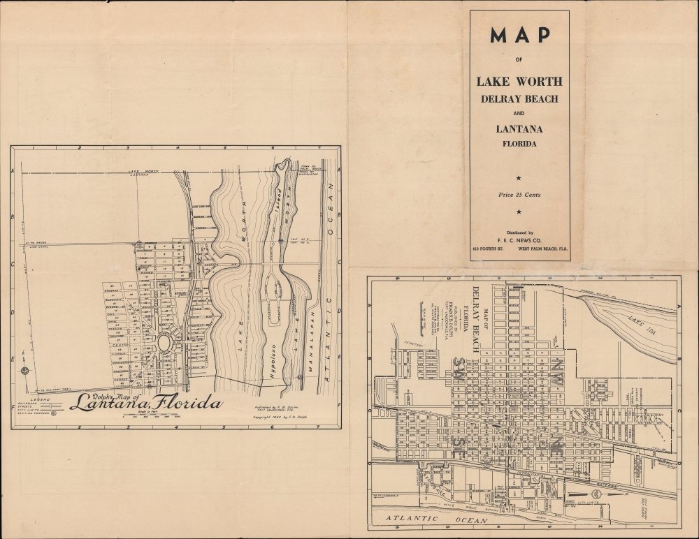
Dolph's Map of Lake Worth Florida / Map of Lake Worth Delray Beach and Lantana Florida.
1945 (dated) 21 x 14.25 in (53.34 x 36.195 cm) 1 : 11000
1945 (dated) 21 x 14.25 in (53.34 x 36.195 cm) 1 : 11000
Description
A highly detailed, unrecorded city plan of Lake Worth (recently renamed Lake Worth Beach), Florida, with maps of nearby Delray Beach and Lantana on the verso, published in 1945 by Frank Dolph.
A Closer Look
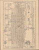
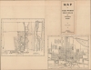
City blocks are illustrated and numbered throughout, reflecting their use as business or residential property according to the schematics offered at right (situated in Lake Laggon, which has been incorporated into the Intracoastal Waterway). Streets, mostly adhering to a grid and employing numbers and letters for names (for example, 3rd Avenue and B Street), are labeled, along with schools, parks, cemeteries, a municipal golf course, City Hall, the Chamber of Commerce, and other public institutions. The Florida East Coast Railway and the Seabord Air Line run north-south through town, parallel to the coast. Smaller maps of Delray Beach and Lantana, further south from Lake Worth towards Boca Raton, appear on the verso, marking out city blocks in the same manner as on the recto.Lake Worth Casino and Baths
The 'Casino and Pool' seen here at the beach (the Mediterranean Revival-style Lake Worth Casino and Baths) were a significant draw for tourists and locals alike when this map was published. Gambling was widespread in Florida before 1935, but public opposition grew due to its perceived adverse effects on society, including the involvement of organized crime. Some laws were passed restricting gambling, and in 1937, all gambling was nominally outlawed in the state. However, local officials often tolerated or encouraged gambling, recognizing its importance to the local economy and guessing (correctly) that state officials would not crack down. In 1947, a hurricane badly damaged the Lake Worth Casino, and it was rebuilt in a less grand style in the early 1950s.Historical Context
Lake Worth is named after the lagoon adjacent to the town, now part of the Intracoastal Waterway, which was itself named for William J. Worth, a commander of U.S. forces in the Second Seminole War. Although a few structures, including a post office, existed in the region in the late 19th century, the town really emerged in the wake of the Florida East Coast Railway when it arrived in 1896. Once a station was opened in 1912, the population increased from 38 to 308 in just a handful of months. Lake Worth was incorporated the following year and generally followed the ups and downs of the Florida Land Boom. The population quintupled between 1920 and 1930, but the 1928 Okeechobee Hurricane, followed by the Great Depression, checked its breakneck development. Although there were no military facilities in Lake Worth during World War II, the war nevertheless did bring soldiers and others to the area, many of whom settled in South Florida after the war.Publication History and Census
This map was prepared and published by Frank B. Dolph in 1945. We are unaware of any examples of it in institutional collections, and it appears to be scarce on the market.Cartographer
Frank B. Dolph (October 3, 1897 - November 26, 1975) was an American businessman and map publisher. Born in Great Neck, Long Island, New York, Dolph served as a Navy storekeeper during World War I. He began selling maps in 1919 after returning from England, likely for the George F. Cram Company, where he ultimately became an administrative aide. He also worked for the Rand McNally Company for some time before he founded his own map publishing firm, Dolph and Stewart, with his friend, sometime in the 1920s. Dolph and Stewart made maps throughout the 1920s and 1930s until they sold the firm in 1945 when Dolph decided to return to Florida. Dolph opened a new map publishing business, the Frank B. Dolph Map Co. in Ft. Lauderdale and published city plans of cities throughout the United States. Many of his maps were distributed by Chambers of Commerce or sold at newsstands. Real estate developers greatly appreciated his maps, those published by both the Dolph and Stewart Company and the Frank B. Dolph Company. Dolph retired as president of his firm around 1965, when he handed the business off to his son, Frank B. Dolph, Jr. Dolph worked with cartographer Theodore M. Politano for decades while operating the Frank B. Dolph Map Company. More by this mapmaker...
Condition
Good. Wear along original folds, with 'pinhole' areas of loss at fold intersections. Tear along fold professionally repaired on verso.