This item has been sold, but you can get on the Waitlist to be notified if another example becomes available, or purchase a digital scan.
1702 De Fer Map of West Indies and the Caribbean
LAmeriqueDAntilles-defer-1702$150.00

Title
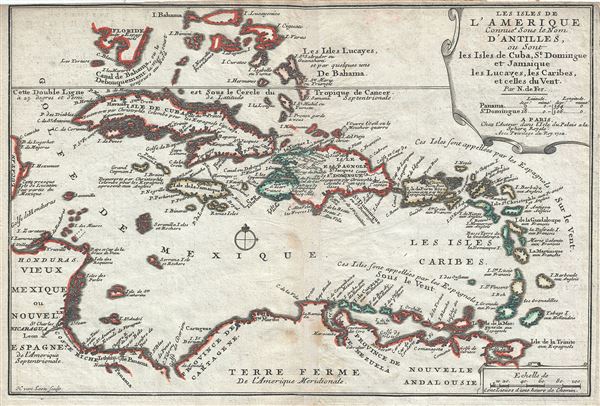
Les Isles de L'Amerique Connues sous le Nom D'Antilles, ou Sont les Isles de Cuba, St. Domingue et Jamaique les Lucayes, les Caribes, et celles du Vent.
1702 (dated) 9.5 x 13.5 in (24.13 x 34.29 cm) 1 : 11000000
1702 (dated) 9.5 x 13.5 in (24.13 x 34.29 cm) 1 : 11000000
Description
This is a scarce and attractive 1702 map of the West Indies by Nicholas De Fer. It covers the Caribbean from the eastern coast of Yucatan east as far as Barbados and from the southern tip of Florida south to Trinidad and Tobago. Includes Cuba, the Bahamas, Puerto Rico, Jamaica, Santo Domingo, and the Lesser Antilles. Renders the region in detail offering both topographical and political information. Florida is misshapen with no trace of the Keys. A note near Florida and Cuba references the Gulf Stream as always flowing north. Further south, the West Indies are fairly well mapped suggesting a relative accurate picture of the islands. There are several references to the explorations of Christopher Columbus. This map was engraved by Harmanus van Loon and created by Nicholas De Fer for his 1702 atlas of Spanish possessions.
CartographerS
Nicholas de Fer (1646 - October 25, 1720) was a French cartographer and publisher, the son of cartographer Antoine de Fer. He apprenticed with the Paris engraver Louis Spirinx, producing his first map, of the Canal du Midi, at 23. When his father died in June of 1673 he took over the family engraving business and established himself on Quai de L'Horloge, Paris, as an engraver, cartographer, and map publisher. De Fer was a prolific cartographer with over 600 maps and atlases to his credit. De Fer's work, though replete with geographical errors, earned a large following because of its considerable decorative appeal. In the late 17th century, De Fer's fame culminated in his appointment as Geographe de le Dauphin, a position that offered him unprecedented access to the most up to date cartographic information. This was a partner position to another simultaneously held by the more scientific geographer Guillaume De L'Isle, Premier Geograph de Roi. Despite very different cartographic approaches, De L'Isle and De Fer seem to have stepped carefully around one another and were rarely publicly at odds. Upon his death of old age in 1720, Nicolas was succeeded by two of his sons-in-law, who also happened to be brothers, Guillaume Danet (who had married his daughter Marguerite-Geneviève De Fer), and Jacques-François Bénard (Besnard) Danet (husband of Marie-Anne De Fer), and their heirs, who continued to publish under the De Fer imprint until about 1760. It is of note that part of the De Fer legacy also passed to the engraver Remi Rircher, who married De Fer's third daughter, but Richer had little interest in the business and sold his share to the Danet brothers in 1721. More by this mapmaker...
Harmanus van Loon (fl. c. 1690 - c. 1725) was a Flemish engraver active in Paris during the late 17th and early 18th centuries. Van Loon worked primarily in Paris and often signed his work, which includes maps and other engravings for such prominent cartographers as Nicolas de Fer, Jean Baptiste Nolin, Guillaume Delisle, and others. There is some speculation that he may have been related to the Brussels born painter Theodorus van Loon. Learn More...
Source
Fer, Nicholas de, Cartes et Descriptions Generales et Particulieres pour l'intelligence des affaires du temps, au sujet de la Succession de la Couronne d'Espagne, en Europe, en Asie, Afrique, et Amerique, (Paris) 1702.
Condition
Very good. Minor wear along original centerfold. Original platemark visible. Minor overall toning and some spotting. Top margin cut off.
References
OCLC 867144107.