
This item below is out of stock, but another example (left) is available. To view the available item, click "Details."
Details
1970 Automobile Club of Southern California Map of Los Angeles and Vicinity
1970 (undated) $200.00
1937 Auto Club of Southern California Map of Metropolitan Los Angeles
LAMetro-autoclubsocal-1937$100.00

Title
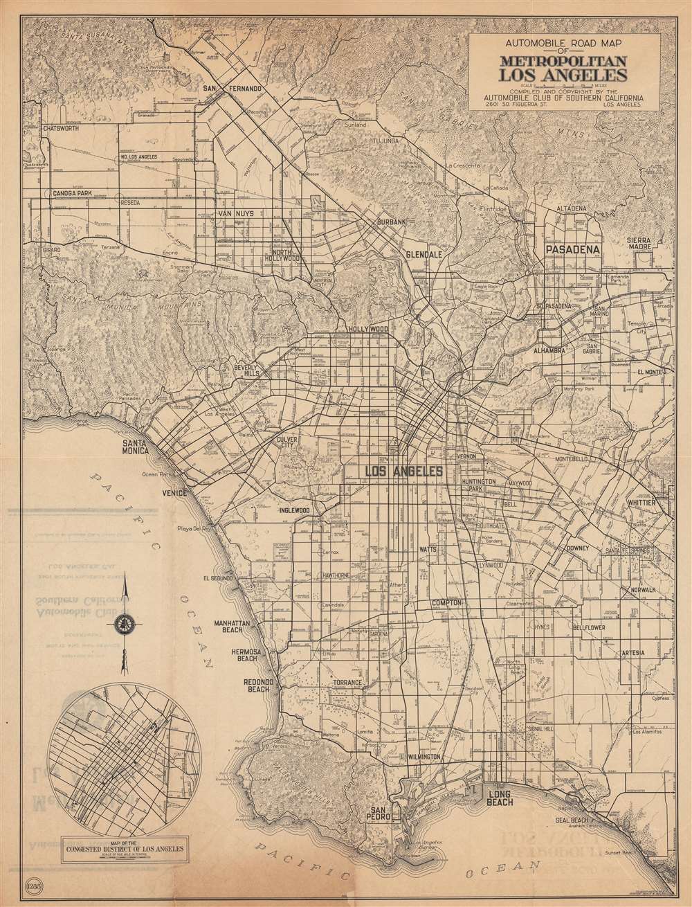
Automobile road map of metropolitan Los Angeles.
1937 (undated) 21.5 x 16.5 in (54.61 x 41.91 cm) 1 : 50500
1937 (undated) 21.5 x 16.5 in (54.61 x 41.91 cm) 1 : 50500
Description
This is a c. 1937 Automobile Club of Southern California city plan or map of Los Angeles. The contours of L.A.’s urban sprawl are apparent, with development along the major boulevards in the San Fernando and San Gabriel Valleys and out towards Orange County, but the freeways that have come to define L.A. had not yet been built.
Major streets are illustrated, including roads that constituted U.S. Route 66 (Colorado Boulevard, Santa Monica Boulevard), though the route itself is not indicated. Small circles mark several oil fields on the west side of Los Angeles, including the Redondo, Venice, and the Rosecrans Oil Fields. Airports, cemeteries, high schools, golf courses, and locations of the Automobile Club of Southern California are also highlighted. Landmarks such as the Hollywood Bowl, in the Santa Monica Mountains above Hollywood, also appear. Peaks are identified in the San Gabriel Mountains, and the elevations for mountains are given in the Santa Monica Mountains and the Santa Susana Mountains. An inset in the lower-left corner details the 'Congested District.'
The rapidly growing population of L.A. County in these years and consequent changes to infrastructure necessitated frequently updated maps, and the Automobile Club of Southern California was happy to meet this demand. Even already constructed roads were redesignated frequently, as with the western portion of Beverly Boulevard through Westwood and Pacific Palisades, which would become the coastal extension of Sunset Boulevard soon after this map’s publication.
A Closer Look
Depicting the region from the Santa Susana Mountains and San Fernando to San Pedro and Long Beach and from Oakwood Cemetery and the Chatsworth Reservoir to Whittier and El Monte. Los Angeles, Pasadena, Glendale, Compton, Inglewood, Beverly Hills, Venice, Santa Monica, and Hollywood rank among the identified cities.Major streets are illustrated, including roads that constituted U.S. Route 66 (Colorado Boulevard, Santa Monica Boulevard), though the route itself is not indicated. Small circles mark several oil fields on the west side of Los Angeles, including the Redondo, Venice, and the Rosecrans Oil Fields. Airports, cemeteries, high schools, golf courses, and locations of the Automobile Club of Southern California are also highlighted. Landmarks such as the Hollywood Bowl, in the Santa Monica Mountains above Hollywood, also appear. Peaks are identified in the San Gabriel Mountains, and the elevations for mountains are given in the Santa Monica Mountains and the Santa Susana Mountains. An inset in the lower-left corner details the 'Congested District.'
The rapidly growing population of L.A. County in these years and consequent changes to infrastructure necessitated frequently updated maps, and the Automobile Club of Southern California was happy to meet this demand. Even already constructed roads were redesignated frequently, as with the western portion of Beverly Boulevard through Westwood and Pacific Palisades, which would become the coastal extension of Sunset Boulevard soon after this map’s publication.
Car Conflicts
Although no legend is present, the ‘Red Car’ lines of the Pacific Electric Railway, a major means of transportation in the city, are shown here by lines and nodes. The ‘Yellow Cars’ of the Los Angeles Railway that operated in downtown are not indicated at all. These exemptions were not accidental. The Automobile Club of Southern California was deeply opposed to the streetcars, both because they saw automobiles as more practical but also because they associated streetcars with political corruption, not without reason as some of the wealthiest families in California had profited from the streetcars’ construction after considerable political finagling. By the time this map was published, the streetcars had lost a large share of their ridership to automobiles but the presence of both modes of transportation on the roads added to traffic congestion, a major motivation for L.A.’s embrace of freeways beginning in the 1940s.Publication History and Census
This map was produced and published by the Automobile Club of Southern California. It is not dated, but from context appears to be from the mid-late 1930s (predates the Hollywood Freeway in Cahuenga Pass, opened in 1940, but postdates the 1932 Olympics). Due to the uncertainty over the date, the exact distribution of this map is difficult to know, but it appears to be held by a handful of academic libraries in the United States and is scarce to the market.Cartographer
The Automobile Club of Southern California (1900 - Present) is an auto club based in Los Angeles, California and an affiliate of the American Automobile Association (AAA). Founded in 1900, it was one of the first auto clubs in the United States and was dedicated to proposing traffic laws, improving road conditions, and the overall improvement of driving conditions. The Auto Club began producing its own maps in 1910, when it sent out its own team of cartographers to survey the state's roads. Its main office at the corner of Figueroa Street and Adams Boulevard was completed in 1923. Numbering nearly 8 million members in its home territory alone, today it is the largest single member of the AAA federation More by this mapmaker...
Condition
Good. A couple areas of repair along fold lines at the margins and at fold intersections on the verso. Fold lines visible and toning towards the top and bottom margins at center-left.
References
OCLC 1261760825.