This item has been sold, but you can get on the Waitlist to be notified if another example becomes available, or purchase a digital scan.
1842 Arrowsmith Map of the Virgin Islands and the Leeward Islands
LeewardIslands-arrowsmith-1842$350.00

Title
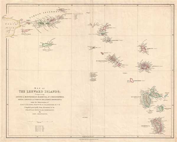
Map of the Leeward Islands; Comprising Antigua, Montserrat, Barbuda, St. Christopher, Nevis, Anguilla, Virgin Islands, and Dominica.
1842 (dated) 18.75 x 24 in (47.625 x 60.96 cm) 1 : 950400
1842 (dated) 18.75 x 24 in (47.625 x 60.96 cm) 1 : 950400
Description
This is an 1842 John Arrowsmith map of the Virgin Islands and the Leeward Islands. The map depicts the Caribbean Sea from Anegada (a British possession) to Dominica (also a British possession) and from Puerto Rico (Porto Rico, which was Spanish) to Deseada (a French possession). Several other islands are depicted, including Angulla (British), St. Martin (both the French and the Dutch halves), St. Bartholomew (Swedish), Saba (Dutch), St. Eustatius (Dutch), St. Christopher (British), Nevis, (British), Montserrat (British), Barbuda (British), Antigua (British), Guadeloupe (French), Marie Galante (French), and the Sainte Islands (French).
Each island is illustrated in detail, with locations along each coast labeled. Distinctions between the colonial powers in control of each island are rendered through color. Thus, the different colors shading the various islands denote which colonial power possessed which island. In the Virgin Islands, for example, shading allows for instant realization that St. Thomas and St. John are owned by a different power (Denmark) than Tortola, Virgin Gorda, and Anegada (British). Locations throughout the Virgin Islands, including smaller islands too small to be colored, are labeled. For example, Anegada Reef, including White Horse and the Long Shoals, is labeled. A notation is included by Anegada Reef listing the number and nationality of vessels wrecked upon the reef since 1811, which numbered 67 in total.
This map was published by John Arrowsmith in 1842 for his London Atlas of Universal Geography. It replaced an earlier edition dating to 1839 and remained in editions of his atlas until at least 1844. Nonetheless, the map has become scarce today.
Cartographer
Aaron Arrowsmith (1750-1823), John Arrowsmith (1790-1873), and Samuel Arrowsmith. The Arrowsmith family were noted map engravers, publishers, geographers, and cartographers active in the late 18th and early 19th century. The Arrowsmith firm was founded by Aaron Arrowsmith, who was trained in surveying and engraving under John Cary and William Faden. Arrowsmith founded the Arrowsmith firm as a side business while employed by Cary. The firm specialized in large format individual issue maps containing the most up to date and sophisticated information available. Arrowsmith's work drew the attention of the Prince of Wales who, in 1810, named him Hydrographer to the Prince of Wales, and subsequently, in 1820, Hydrographer to the King. Aaron Arrowsmith was succeeded by two sons, Aaron and Samuel, who followed him in the map publication business. The Arrowsmith firm eventually fell to John Arrowsmith (1790-1873), nephew of the elder Aaron. John was a founding member of the Royal Geographical Society. The firm is best known for their phenomenal large format mappings of North America. Mount Arrowsmith, situated east of Port Alberni on Vancouver Island, British Columbia, is named for Aaron Arrowsmith and his nephew John Arrowsmith. More by this mapmaker...
Source
Arrowsmith, J., The London Atlas of Universal Geography, (London) 1842.
Condition
Very good. Light wear along original centerfold. Blank on verso.
References
Rumsey 4613.063. OCLC 47906453.