This item has been sold, but you can get on the Waitlist to be notified if another example becomes available, or purchase a digital scan.
1918 Matthews Northrup Wall Map of Northern France WWI Western Front
LibertyMapWesternFront-matthewsnorthrup-1918$375.00

Title
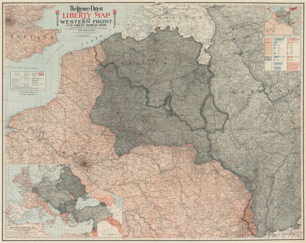
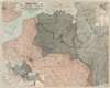
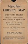
The Literary Digest Liberty Map of the Western Front of the Great World War Showing the Battle Line of Liberty as it Stood June 5, 1918.
1918 (dated) 40 x 50.25 in (101.6 x 127.635 cm) 1 : 500000
1918 (dated) 40 x 50.25 in (101.6 x 127.635 cm) 1 : 500000
Description
This is a 1918 Matthews-Northrup wall map of northern France, Belgium, Germany, and the surrounding region highlighting the World War I Western Front as of June 5, 1918. A tricolor blue, white, and red line (reminiscent of the French flag) traces the front from the North Sea to Switzerland through parts of western Belgium and northern France. Entente Powers (Britain and France) are shaded pink, while hues of gray fill in members of the 'Teutonic Allies' (Germany) or territory occupied by them (Belgium, Luxembourg, and northeastern France). A blue dashed line marks Germany's farthest advance, while a red dashed line illustrates the advancement of French forces. An accompanying index identifies over 11,000 place names. An inset in the upper right highlights coal and iron regions in occupied territory and Germany and a table just below it quantifies the production. An inset in the lower left corner depicts everywhere fighting was happening around the world. Red lines reinforce these disparate regions: northern France, Russia, Romania, northeastern Italy, Greece, Palestine, and modern-day Iraq.
Publication History and Census
This map was engraved and printed by Matthews-Northrup and copyrighted by Funk and Wagnalls in 1918. An empty OCLC reference exists for this piece, suggesting that a former cooperative member created the entry before withdrawing from OCLC. Several editions were published highlighting the battle line on the Western Front at different points in 1918. We have located editions dated to April 15, May 1, June 5 (present example), August 5, and September 5. We are aware of only one other example of the June 5 edition, held in a private collection.Cartographer
Matthews-Northrup Works (fl. c. 1895 - 1930) were a Buffalo, New York based, in their own words, "writing, designing, engraving, printing, [and] binding" firm. The firm was founded by James Newson Matthews (November 21, 1828 - December 20, 1888) as the J. N. Matthews Company. William Phelps Northrup (April 2, 1850 - February 2, 1929) later joined the company as an apprentice and then partner, at which point the firm was reincorporated as the Matthews-Northrup Works. The Matthews-Northrup Works rose to prominence as publishers and printers of railroad maps, with dozens to their credit. When James died, his shares were inhered by George Edward Matthews (1855 - 1910), who ran the business until his death in 1910. Also in 1910, they famously redesigned the cover of National Geographic Magazine. Despite some six previous cover changes in just 21 years, the Matthews-Northrup layout proved so popular that it was used for nearly 50 years. The firm can also take credit for the Winchell typeface, designed in 1903 under E. E. Winchell's tenure as art director. Curiously, the partners of Matthews-Northrup maintained an unusual affectation in which only the officers of the company could wear beards or mustaches. In this same spirit, the firm also had its own private social club, the Fellowcraft Club, where the all-male employees could relax, play pool, drink and dine. Matthews-Northrup maintained offices on Washington Street, Buffalo, where they were based, as well as Madison Square, New York City, Garden Tower, Boston, and the Citizens Building in Cleveland. More by this mapmaker...
Condition
Good. Exhibits wear along original fold lines. Verso repairs to fold separations. Exhibits areas of infill.
References
OCLC 76891082.