This item has been sold, but you can get on the Waitlist to be notified if another example becomes available, or purchase a digital scan.
1899 Bacon Pocket Plan or Map of London
London-bacon-1899$125.00

Title
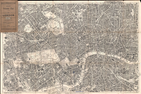
Bacon's Portable Map of London.
c. 1899 (undated) 19.5 x 29.5 in (49.53 x 74.93 cm)
c. 1899 (undated) 19.5 x 29.5 in (49.53 x 74.93 cm)
Description
Extremely attractive map of London, England aroun the turn of the century. Issued c. 1899 by G. W. Bacon, this map covers central London along the Thames River from Fulham Cemetary in the west to Southwark Park in the southeast. Extends north as far as Canonbury and Kentish Town. Includes Regents Park, Kensington Garden, Hyde Park, St. James Places, the London Docks, the Great North Railway Dept and London Fields, among other destinations. Labels all streets, ferry routes, bridges, train routes, parks, and countless important buildings and civic constructions. Folds into original wax paper binder.
Cartographer
George Washington Bacon (1830 - 1922) was a London based book and map publisher active in the mid to late 19th century. Bacon's firm G.W. Bacon and Co. purchased the plates created by Edward Weller for the Weekly Dispatch Atlas then modified and updated them for several of their own important atlases, including The New Ordnance Atlas of the British Isles. In 1893, Bacon & Co. acquired the map publishing business of J. Wyld. Then, around the turn of the century, Bacon & Co. itself was folded into the Scottish publishing house of W.& A.K. Johnston. More by this mapmaker...
Condition
Good. Original folds exhibit some wear and have old repairs on verso. A few minor pen marks bottom center identifying the location of the New Horticultural Hall.