This item has been sold, but you can get on the Waitlist to be notified if another example becomes available, or purchase a digital scan.
1885 Davies Map of London, England
London-davies-1885$550.00

Title
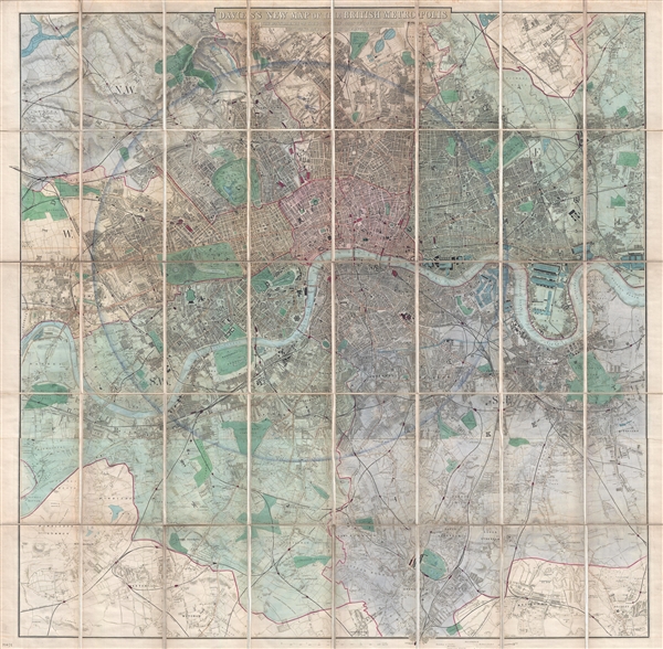
Davies's New Map of the British Metropolis. The Boundaries of the Boroughs, County Court Districts, Railways, and Modern Improvements.
1885 (dated) 38 x 38 in (96.52 x 96.52 cm) 1 : 21120
1885 (dated) 38 x 38 in (96.52 x 96.52 cm) 1 : 21120
Description
A fine 1885 example of Davies's fine large scale map of London. Roughly centered on Charing Cross the Thames River, the map covers from Brent Reservoir to Bromley, and from New Wanstead to Cottenham Park. A shaded circular area at the center of the map highlights the most developed parts of London within a 4-mile radius of Charing Cross. The impressive scale of the map allows Davies to incorporate an incredible amount of detail, with most streets, important buildings, piers, bridges, parks, and markets noted.
This map was first published about 1860 and went through many subsequent editions. The present edition was issued with updates to 1885. It was drawn by Benjamin Rees Davies and published by Edward Stanford.
This map was first published about 1860 and went through many subsequent editions. The present edition was issued with updates to 1885. It was drawn by Benjamin Rees Davies and published by Edward Stanford.
CartographerS
Benjamin Rees Davies (1789 - December 16, 1872) was an engraver, cartographer, painter, and map publisher active in the early to mid-19th century. Davies was born in Holborn, England, apprenticed as under John Lodge in 1803. He began publishing around 1811 and is known to have compiled many of own maps from original survey work. From approximately 1848 onward Davies published in conjunction with the Stanford Firm. He is also known to have engraved a number of maps for the Dispatch Atlas and the S.D.U.K. Davies was an early adopter of steel plate engraving and used the exceptional hardness of steel to create some of the most delicately engraved and beautifully produced maps of his era. He was quite famous in England for his detailed street plans of London, which he began publishing in 1848. Davies is known to have worked with numerous other cartographers of his period including French, Mexican, and American map makers. Many of his maps and plans continued to be published and updated posthumously well into the 1880s. More by this mapmaker...
Edward Stanford (May 27, 1827 - November 3, 1904) was one of the most prolific map publishing firms of the late 19th century. The company began as a partnership in 1848 between the 21 year old Edward Stanford and the established map dealer Trelawney Saunders. By 1853 the partnership had dissolved and Edward Stanford took full control of the business. A subsequent series of expansions and exciting new map issues finally led to the production of Stanford's masterwork, "Stanford's Library Map of London". This map is still available and remains somewhat accurate. At the time of publishing it was hailed by the Royal Geographical Society as "the most perfect map of London that has ever been issued". In 1882 Edward Stanford Sr. passed the firm on to his son, Edward Stanford Jr. who continued in his father's proud tradition. Today the Stanford firm still publishes maps and remains one of the most important and prolific cartographic publishers in the world. Learn More...
Condition
Very good. The map is detached from but accompanies its original linen binder. Dissected and mounted on linen in 40 panels. Original linen is intact but weak at fold intersections. Reinforced on verso in several places.
References
OCLC 316453938. Hyde, Ralph, Printed Maps of Victorian London, 1851 - 1900.