1851 Heck German City Plan of London, Great Exhibition
London-heck-1851$1,200.00


Title
J.G. Heck's neuester Plan von London und seinen Umgebungen.
1851 (dated) 25 x 29.5 in (63.5 x 74.93 cm) 1 : 19500
1851 (dated) 25 x 29.5 in (63.5 x 74.93 cm) 1 : 19500
Description
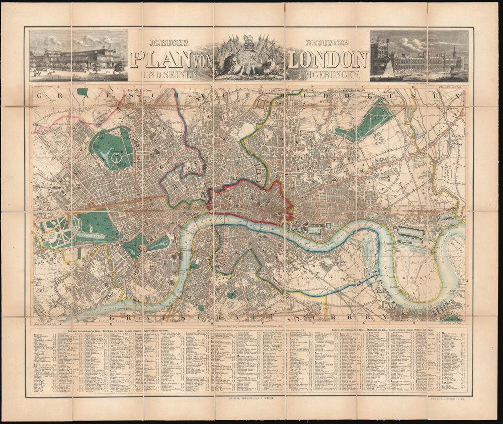
This is Johann Georg Heck's 1851 large-format German-language folding map of London. Providing a detailed overview of central London, it was published for German tourists visiting the Great Exhibition of 1851.
Beneath the map is an extensive alphabetical index of towns, neighborhoods, public buildings, streets, squares, and parks (the map's original owner has underlined and made faint notes near several attractions including the Crystal Palace, British Museum, and Westminster Abbey). Notably, the map points out the position of the 'Crystal Palace' (Industrie Ausstellungs Gebäude) on the south edge of Hyde Park; in 1854, the palace was moved to a location south of London (beyond the scope of this map), where it stood until burning down in 1936. Other interesting ephemeral features appear, such as a suspension bridge at Hungerford Market (the Hungerford Bridge), which was replaced with a railway bridge in 1864, and a ghosted-in proposed bridge between Millbank and Lambeth, ultimately opened in 1862.
A Closer Look
The map covers central London, with the City of London and inner boroughs (Finsbury, Southwark, Westminster, etc.) outlined in hand color for easy distinction. Neighborhoods, counties, towns, and other constituent parts of the boroughs are also labeled, as are a wide range of public buildings, including train stations, parks, museums, hospitals, prisons, markets, palaces, and more. The map employs a curious prime meridian and an equator-like parallel, both based on St. Paul's Cathedral. At top are vignette illustrations of the Crystal Palace of the Great Exhibition and the Houses of Parliament (minus the clock tower 'Big Ben,' which was under construction at the time but not completed until 1859), plus a decorative cartouche with British royal symbols.Beneath the map is an extensive alphabetical index of towns, neighborhoods, public buildings, streets, squares, and parks (the map's original owner has underlined and made faint notes near several attractions including the Crystal Palace, British Museum, and Westminster Abbey). Notably, the map points out the position of the 'Crystal Palace' (Industrie Ausstellungs Gebäude) on the south edge of Hyde Park; in 1854, the palace was moved to a location south of London (beyond the scope of this map), where it stood until burning down in 1936. Other interesting ephemeral features appear, such as a suspension bridge at Hungerford Market (the Hungerford Bridge), which was replaced with a railway bridge in 1864, and a ghosted-in proposed bridge between Millbank and Lambeth, ultimately opened in 1862.
The 1851 Crystal Palace Exhibition, or Great Exhibition
The 1851 Crystal Palace Exhibition, officially titled the Great Exhibition of the Works of Industry of All Nations, was a landmark event held in London's Hyde Park. It was organized by Prince Albert (1819 - 1861) and Sir Henry Cole (1808 - 1882), who envisaged an international platform to showcase the innovations, arts, and technological prowess of the era. The venue, the Crystal Palace, was an architectural marvel in itself - an expansive iron and glass edifice designed by Sir Joseph Paxton (1803 - 1865) that was three times larger than St. Paul's Cathedral - symbolizing the union of art, design, and engineering. Exhibitors flocked to this event, displaying a diverse array of products ranging from machinery to exotic artifacts, revealing the vast expanse of 19th-century human achievement. Drawing over 6,000,000 visitors, including dignitaries, intellectuals, and curious citizens, the exhibition was not merely a commercial or technological display; it was a cultural spectacle that emphasized Britain's central role in the Industrial Revolution. Moreover, the legacy of the Great Exhibition extended beyond its temporal confines, influencing design principles, shaping international trade and diplomacy, and inspiring subsequent world fairs and expositions.Publication History and Census
This map was prepared by Johann Georg Heck, engraved by R. Schmidt, and published by Johann Jacob Weber in Leipzig in 1851. It is quite rare, only being noted in the OCLC among the holdings of the Newberry Library, British Library, Staatsbibliothek zu Berlin, and Sächsische Landesbibliothek - Staats- und Universitätsbibliothek.CartographerS
Johann Georg Heck (1795 - November 20, 1857) was a German engraver, cartographer, geographer, writer, lithographic printer, and publisher based in Leipzig. Heck was born in Strasbourg; little is known of his training but he became involved in the new technology of lithographic printing and was made head of the lithographic department at the Freiburger Kunstinstituts, founded by Bartholomä Herder (1774 - 1839). Heck remained at the institute until 1828, after which he managed a German-French bookstore in Paris and then headed the Paris branch of the publisher Herder and Cie. In 1834, he married Johanna Herder (1803 - 1887), the daughter of Bartholomä Herder. He was best known for several reference works that were published in English and French as well as German, especially his ten-volume Bilder-Atlas zum Conversations-Lexikon. Ikonographische Encyclopädie der Wissenschaften und Künste (published by F. A. Brockhaus), with 500 steel-engraved plates and more than 12,000 illustrations, which was one of the most popular reference works of the 19th century. He also published geographic atlases and separate issue maps in French, English, and German. More by this mapmaker...
Friedrich Arnold Brockhaus (May 4, 1772 - August 20, 1823) was a German publisher and editor. He was born in Dortmund and from 1788 - 1793 apprenticed at a mercantile concern in Düsseldorf. He subsequently studied language and literature at the University of Leipzig, then went on to establish a Dortmund-based concern importing and selling English goods. He developed his business in Amsterdam for a time before economic pressures forced him to close. He turned to publishing, founding 'F. A. Brockhaus', in 1805. The firm was initially based in Amsterdam, but in 1811 relocated to Altenburg, Germany, then, in 1818, to Leipzig. There he established a large printing house dedicated to encyclopedias, scientific publications, and literature. Friedrich Arnold died in Leipzig in 1823, but the business was taken over by his sons, Friedrich Brockhaus (1800 - 1865), who retired in 1850, and Heinrich Brockhaus (1804 - 1874), under whom it was considerably extended. Their most significant publication was the Brockhaus Enzyklopädie, also known as Der Grosse Brockhaus. In 1953, after World War II (1939 - 1945), its Leipzig operations were nationalized by East Germany. Its West German successor established itself in Wiesbaden. Following German reunification, corporate headquarters were moved to Munich. The firm continues to publish as F. A. Brockhaus AG. Learn More...
Johann Jacob Weber (April 3, 1803 - March 1880) was a Swiss book publisher active in Leipzig. Weber was born in Basel apprenticed under bookseller Emanuel Thurneysen. Following his apprenticeship he went on to work with J. J. Pachoud in Genevia, Firmin Didot in Paris, and Breitkopf and Hartel in Leipzing, and Herderian in Freiburg. In 1830 he took work in the Leipzig branch of the Parisian publishing firm of Ange Pere. Four years later, in 1834 he founded his own firm, J. J. Weber, which employed modern printing techniques and was known for sophisticated forward-thinking design work. In 1843 Weber founded the illustrated newspaper Illustrierte Zeitung. The Illustrierte Zeitung was a revolutionary publication for Germany and rekindled a general interest in German printmaking. As a person Weber was said to be of an unpretentious and modest nature who was passionate for his profession. His sons Hermann, John and Felix W. took over the management of the businesses, which continued to be passed down in the family. The firm of J. J. Weber remained active well into the 20th century. Learn More...
Condition
Very good. Some surface toning along fold lines. Dissected and laid on linen. Original linen backing stable.
References
OCLC 315042748, 497827075.