This item has been sold, but you can get on the Waitlist to be notified if another example becomes available, or purchase a digital scan.
1895 Philip Pocket Map or Plan of London, England
London-philip-1895$325.00

Title
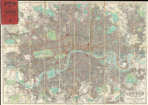
Philips' New Map of London Extending Four & a Half Miles Round Charing Cross.
c. 1895 (undated) 29 x 40 in (73.66 x 101.6 cm)
c. 1895 (undated) 29 x 40 in (73.66 x 101.6 cm)
Description
A stunning example of George Philip's c. 1985 folding pocket map of London, England. Covers the urban center of London from Barnes in the west to Victoria Dock in the east, as well as north as far as Finsbury Park and south as far as Brockwell Park, thus covering London in a roughly 4.5 mile radius from Charing Cross. Offers incredible detail at a scale of 3 inches to 1 mile, with notation for all major streets, trains lines, parks, docks, districts, and important buildings. Issued as part of the 'Handy Series of Pocket Maps' issued by George Philip & Son from their offices at 32 Fleet Street, London, England.
Cartographer
George Philip (1800 - 1882) was a map publisher and cartographer active in the mid to late-19th century. Philip was born into a Calvinst family in Huntly, Aberdeenshire, Scotland. Around 1819 he apprenticed himself to William Grapel, a Liverpool printer and bookseller. Fifteen years later, in 1834, Philip founded his own Liverpool book and map firm. Philip's earliest cartographic ventures were mostly educational material issued in tandem with John Bartholomew Sr., August Petermann, and William Hughes. In 1848, Philip admitted his son, George Philip Jr. (1823 - 1902) into the firm, renaming it George Philip and Son Ltd. George Philip Jr. ran the firm until his death in 1902, by which time it had developed into a major publishing concern. His successors established the London Geographical Institute, a factory where they embraced modern printing techniques to produce thousands of economical and high quality maps. In April 1988, George Philip & Son was acquired by Octopus Publishing, a branch of Reed International. Nonetheless, today the firm trades and publishes to this day as George Philip and Son. More by this mapmaker...
Condition
Very good. Dissected and mounted onto linen in 50 panels. Folds into original linen binder.
References
Hyde, Ralph, Printed Maps of Victorian London, 1851 - 1900, 223B/5.