This item has been sold, but you can get on the Waitlist to be notified if another example becomes available, or purchase a digital scan.
1868 Reynolds Waist-Pocket Map of London, England
London-reynolds-1869$150.00

Title
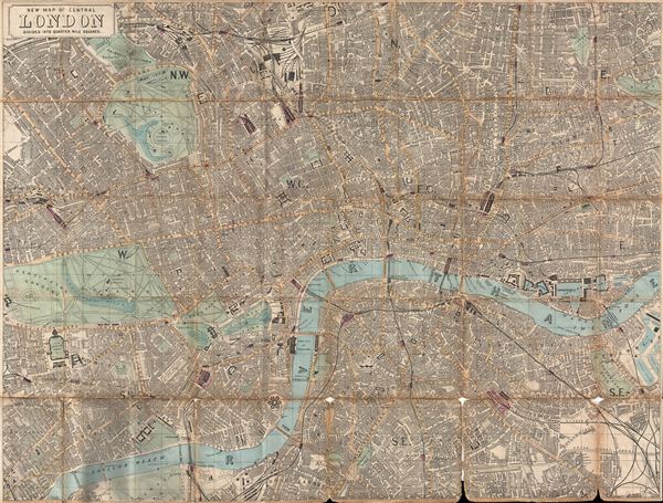
New Map of Central London Divided into Quarter Mile Squares. (Waistcoat-Pocket Map of London)
1869 (undated) 16.4 x 22 in (41.656 x 55.88 cm)
1869 (undated) 16.4 x 22 in (41.656 x 55.88 cm)
Description
An uncommon miniature 1868 pocket map of London, england by James Reynolds. Centered on the Thames River, the map covers from Islington to Rotherhithe and from South Lambeth to Kensington Gardens. The map names all streets, rail lines, important buildings, parks, docks, bridges, and rail terminals. Maps of this type are commonly presented, as in this example, on linen for easy folding and unfolding. They were designed with the traveler in mind are sized to fit into a coat, or in this case, waist-coat, pocket. The present example is the second edition of this map published by Reynolds and Sons of 174 Strand Street, London.
Cartographer
James Reynolds (1817-1876) was a London based map and chart publisher active in the mid-19th century. Reynolds produced numerous maps and tourist guides of London and the surrounding areas as well as various astronomical and scientific charts. After Reynolds retired his sons, William Henry and Frederick, took over his business, updating and reprinting many of his maps and charts before selling the firm to Charles Smith in the late 19th century. Reynolds operated out of office at 174 Strand Street, London. More by this mapmaker...
Condition
Good. Linen backing split in places, especially in the lower right quadrant, leading to slight loss at fold intersections at map's lower margin. Folds into original cardboard binder.
References
Hyde, R., Printed Maps of Victorian London: 1851 - 1900, no. 97-2.