1675 Ogilby Road Map, London to Montgomery, Wales
LondonMontgomery-ogilby-1675$400.00

Title
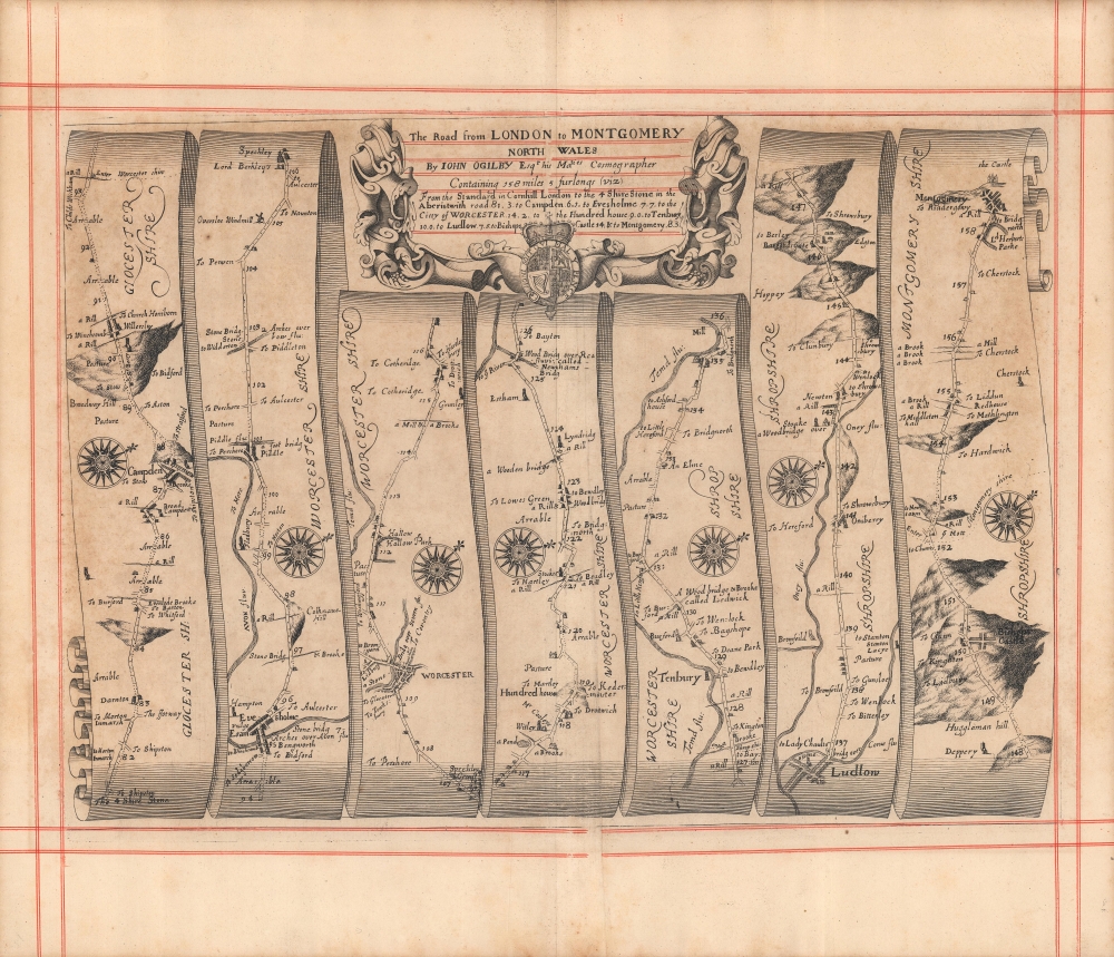
The road from London to Montgomery North Wales...
1675 (undated) 17 x 20 in (43.18 x 50.8 cm) 1 : 63360
1675 (undated) 17 x 20 in (43.18 x 50.8 cm) 1 : 63360
Description
A c. 1675 strip road map by John Ogilby depicting the road from London to Montgomery in Wales. This map represents an early and thus innovative example of this distinctive genre. It was engraved for Ogilby's Britannia, Volume the first: An illustration of the kingdom of England and dominion of Wales.
From the Four Shire Stone, the road progresses through the towns of Broad Campden, Campden (now Chipping Campden), Willersley (Willersey), Evesholm (Evesham), Piddle (Wyre Piddle), Sprechley (Spetchley), Worcester, Witley, Lyndridg (Lindridge), Tenbury, Ludlow, Stoake (Stokesay), Bishop's Castle, and then to Montgomery. No single automobile road follows this route, though it overlaps with portions of the A44, A443, A49, and B4385.
A Closer Look
The route begins at bottom-left at the Four Shire Stone, the boundary marker for the traditional meeting point of Warwickshire, Oxfordshire, Gloucestershire, and Worcestershire. The caption below the title informs that the stone is 81.3 miles from central London. The numbers next to the road continue the numeration of this distance to Montgomery, 158 miles from London. Each strip is slightly differently oriented in a general northwesterly direction as indicated by the compass roses to allow for presentation in vertical strips. A variety of features such as bridges, churches, prominent trees and hills, and other landmarks are noted to assist the traveler in finding their way.From the Four Shire Stone, the road progresses through the towns of Broad Campden, Campden (now Chipping Campden), Willersley (Willersey), Evesholm (Evesham), Piddle (Wyre Piddle), Sprechley (Spetchley), Worcester, Witley, Lyndridg (Lindridge), Tenbury, Ludlow, Stoake (Stokesay), Bishop's Castle, and then to Montgomery. No single automobile road follows this route, though it overlaps with portions of the A44, A443, A49, and B4385.
Britannia and the Development of Strip Maps
Strip maps served to inform travelers of the distances, landmarks, obstacles, and resting points along a given road between two destinations. Changes in direction along the way are indicated by the placement of attractive compass-roses. The wise traveler, of course, would never leave the high road. Consequently, no further routes would require consideration. Britannia was based on firsthand survey by Ogilby and his team, who published their results at a uniform scale of one inch to one mile. In doing so, Ogilby standardized the English mile throughout his book at 1,760 yards (prior to this, no such uniformity existed in England). Ogilby's work was the first to utilize strip maps of this kind, but the 18th century would see similar works published by Bowen, Gardner, Colles, and Senex. Both conceptually and aesthetically, the legacy of Ogilby's work can be seen even in the automobile era, in the strip maps produced by hotels, tourist attractions, and automobile clubs, most notably the Automobile Club of Southern California.Publication History and Census
This map was first published in John Ogilby's 1675 work Britannia, Volume the first: An illustration of the kingdom of England and dominion of Wales, which was republished in 1698 and thereafter 'improved' editions were published by other cartographers such as Emanuel Bowen. The present example does not include the pagination present on the corresponding map in either edition of Ogilby's Britannia nor the subsequent improved editions and the design of the border is distinct, suggesting that it was separately issued.Cartographer
John Ogilby (November 17, 1600 - 1676) was a Scottish translator and cartographer. John Ogilby's life seems to be one of extremes, teetering between wealth and poverty, success and failure. Ogilby was born near Edinburgh, Scotland, into a once wealthy family laid low by extreme debt. Struggling with poverty at every turn, Ogilby involved himself in various businesses ranging from dancing master, to actor, to tutor. In 1612, at age 12, Ogilby won a lottery run to advance the colonial interests of Virginia. His winning were sufficient to pay of many of his father's debts and apprentice himself to a dancing master. Ogilby proved a natural and graceful dancer and even made extra money tutoring his fellow apprentices. Starcrossed as he was, Olgiby's dancing career ended when a misstep when a misstep at a masked ball injured his leg and left him lame for live. Afterwards he managed to leverage his contacts in the dance world to secure a position as a dance instructor to the daughters of Sir Ralph Hopton. Hopton struck an immediate friendship with Olgiby and trained him in Military Science. Later Ogilby relocated to Ireland where he worked an as actor and later as Master of Revels. The Irish Rebellion of 1641 again dashed Ogilby's fortunes and forced him to flee Dublin by ship. On the way, the ship sunk but the survivors were rescued and eventually made their way to England, which was then under the strict rule of Oliver Cromwell. Ogilby took refuge at Cambridge where he mastered Greek and Latin. Following the Restoration of Charles II, Ogilby invested in his first major literary venture, a translation of Virgil into English. This work earned him the patronage of Charles II, despite the ridicule of prominent poets Dryden and Pope. Under Royal patronage Ogilby published several volumes relating to the Restoration. In short order he has established a successful London publisher based out of the Whitefriars district. This, unfortunately turned out to be a fateful choice of location as in 1666 the Great Fire of London tore through this are destroying Ogilby's publishing stock, home, and business. Once again Ogilby exhibited a remarkable phoenix-like ability to literally rise from the ashes. Shortly after the Great Fire, he began his most important ventures as a publisher of geographical works. In order to recover from the fire, Ogilby and his grandson were took positions as surveyors commissioned to create a large property map of London. The resultant map of London, "London Survey'd", was published in 1677 and earned Ogilby the honorific "Kings Cosmographer and Geographic Printer". His most famous works are his 1675 Road Atlas of England, Britannia which redefined road mapping, and his 1671 Atlas of the Americas. More by this mapmaker...
Condition
Very good. Centerfold visible. Some uneven toning along the edge.