This item has been sold, but you can get on the Waitlist to be notified if another example becomes available, or purchase a digital scan.
1934 Geographia Pictorial Map of London, England
LondonPictorial-geographia-1934$125.00

Title
Geographia Pictorial Map of London.
1934 (dated) 19 x 29 in (48.26 x 73.66 cm) 1 : 21100
1934 (dated) 19 x 29 in (48.26 x 73.66 cm) 1 : 21100
Description
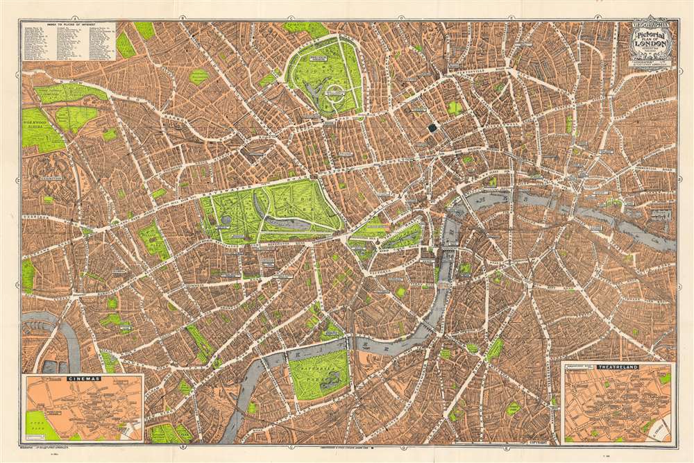
This is a wonderful pocket map of London published in August of 1934 by Geographia Ltd. It covers downtown London from the Hammersmith Bridge and Wormwood scrubs eastward past Hyde Park and Buckingham Place to Whitechapel Road and the London Docks. Unlike most English city plans of the period, this map replicates the pictorial style which popular in Paris during the early part of the 20th century.
A Closer Look
The map features many of the buildings of London drawn in three dimensions. Gardens and parks are beautifully rendered in green with illustrations of ships sailing in the Thames River. Bridges, museums, cathedrals etc. are also identified. Insets in the lower right and lower left depict Theaterland and Cinemas, respectively. Both insets detail individual establishments as they existed at the time including the Regal, Marblearch Pavilion, The Palladium, the Hippodrome Theater, and the Coliseum Theater, among many others. Notes stations on the London Underground. An index in the top left quadrant notes several places of interest.Publication History and Census
This map was first published in the 1920s from the 33 Fleet Street address. In early editions of the map, the 'Cinema' inset in the lower left instead represented 'Clubland', naming some 87 private gentleman's clubs. In an attempt to reach a wider, more modern audience, 'Clubland' was replaced with 'Cinemas' in the 1930s, reflecting also changing interests. Most examples, like the present, feature a peculiar coded dating system in the lower left, below the bottom border (see cartographer bio below). The present example features N.MB, this September, 1934. Published in London at 55 Fleet Street, London by Geographia Ltd.Cartographer
Geographia, Ltd. (1911 - 1985) was a London-based cartographic publishing firm. The company was founded by Alexander Gross (1879 - 1958), a Hungarian immigrant to the United Kingdom. Geographia Ltd. is best known for its folding pocket maps and globes. Many of his maps were drawn by a mysterious 'Mr. Fountain', of whom we have been able to discover little. Gross ran into financial problems around 1940, likely associated with World War II, and relocated to offices in New York at 11 John Street. There, he issued a large corpus of U.S.-focused maps and city plans. By the 1940s, the branch in the United States had been renamed the Geographia Map Company and experienced rapid growth. By the 1950s, Geographia had published maps of dozens of cities across the United States. In 1987, the British branch was bought out by Harper Collins and continues to produce maps under the Collins Bartholomew imprint. Rand McNally bought the New York-based Geographia Map Company in the late 1980s. However, its original owners repurchased the Geographia Map Company a few years later and still operate the company in Hackensack, New Jersey. Gross's daughter, Phyllis Isobella Gross / Pearsall (1906 - 1996), founded the Geographers' A-Z Map Company in London, the largest independent map publisher in the United Kingdom. In the UK, their offices were originally at 33 Strand, where they published as 'Geographia Designing and Publishing Company Ltd.'. Later, by 1933, they had relocated to 55 Fleet Street, where they remained until at least 1937. By 1942, they relocated to 167 Fleet Street, followed by 114 Fleet Street by 1964. It is of note that many of the Geographia Ltd. maps feature a peculiar dating system wherein the letters in the world CUMBERLAND correspond to the numbers 1234567890, such that a date is rendered by substitution, so A.MU would break out like this A = 8, M = 3, U = 2, so 8.32 or, August 1932. Or, MM.YY e.g. E.MC = 5.31 = May 1931. More by this mapmaker...
Condition
Very good. Minor wear and verso reinforcement along original fold lines. Folds into its original paper binder. Russell Square inked.
References
Johns Hopkins University Library, G5754.L7A5 s22.