1914 Hammond Road Map of Long Island w/ New York City
LongIsland-hammond-1918$600.00


Title
Hammond's New Road Map Long Island.
1918 (undated) 16.25 x 25.5 in (41.275 x 64.77 cm) 1 : 126720
1918 (undated) 16.25 x 25.5 in (41.275 x 64.77 cm) 1 : 126720
Description
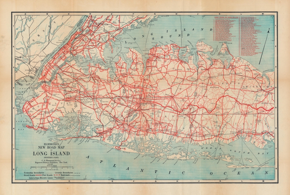
A highly detailed 1918 C.S. Hammond double-sided road map of Long Island and New York City. It demonstrates the transformation of Long Island from rural farmland and forest to a suburban continuation of the New York metro area, a transformation facilitated by the rapid development of highways.
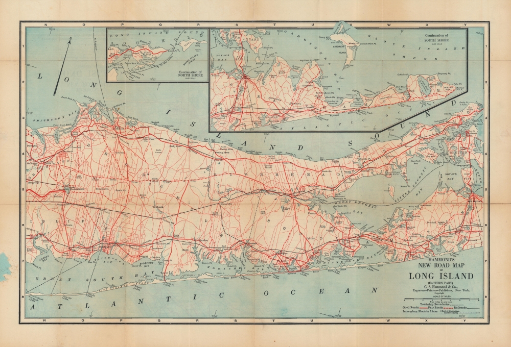
A map of eastern Suffolk County occupies the other side of the map. Major roads are illustrated and are differentiated between 'good roads' and 'fair roads'. Riverhead, Southold, and Southampton are illustrated. An inset along the upper border continues along the South Shore and focuses on East Hampton. A second, smaller inset continues the North Shore and illustrates Orient Point, Gardiners Bay, and Plum Island.
A Closer Look
One side of the map illustrates New York City, Nassau County, and the western portion of Suffolk County, depicting from New Jersey east to Smithtown and Central Islip. Red lines highlight major highways. The street grid in Brooklyn, Manhattan, and the Bronx is illustrated, along with certain neighborhoods in Queens, including Long Island City, Flushing, and Corona. Towns farther east on Long Island are labeled, many of which have small street grid illustrations as well. The Long Island Railway is depicted, as are long-distance trolleys or electric railway lines. Circled numbers on the map correspond to a list of golf clubs on Long Island at top-right.A map of eastern Suffolk County occupies the other side of the map. Major roads are illustrated and are differentiated between 'good roads' and 'fair roads'. Riverhead, Southold, and Southampton are illustrated. An inset along the upper border continues along the South Shore and focuses on East Hampton. A second, smaller inset continues the North Shore and illustrates Orient Point, Gardiners Bay, and Plum Island.
Before the LIE
The first express roadways for automobiles on Long Island opened in the years before this map's publication, most notably the Vanderbilt Parkway (here as the Long Island Motor Parkway), privately built by William Kissam Vanderbilt II in 1908 for racing purposes. The Jericho Turnpike (NY 25), Hempstead Turnpike (NY 24), and other turnpikes and parkways appear here. By the 1920s and 1930s, a growing bureaucracy was required at the local, county, and state levels to manage the rapidly changing landscape of Long Island. Deeply involved with such efforts was Robert Moses, later a famous (or infamous) urban planner, who began his career as President of the Long Island State Park Commission. Among his greatest impacts on Long Island was the prioritization of automobile parkways, making the suburban sprawl of the mid-20th century possible.Publication History and Census
This map was created and published by C.S. Hammond in 1918. Several other editions of the map exist from the 1910s and 1920s, all of which are scarce. The current edition is listed among the institutional holdings of the New York State Library, the New York Public Library, the Brooklyn Public Library, and Stony Brook University.Cartographer
Caleb Stillson Hammond (1862 - 1929) was the founder of C. S. Hammond & Company, a map making and printing firm based in Brooklyn, New York. Hammond started his career in mapmaking as the head of Rand McNally's offices in New York City, where he began working in 1894. Hammond split with Rand McNally, forming his own printing concern in Brooklyn, New York, in 1900. The firm was subsequently incorporated in 1901 and relocated to Manhattan, and then to Maplewood, New Jersey, near Hammond's family home. Hammond rose to become one of the largest cartographic publishers in the United States, second only to Rand McNally in volume. On his retirement, C. S. Hammond passed the firm to his son, who subsequently passed it to his own son, C. D. Hammond, who sold the company to Langenscheidt Publishers in 1999. The firm has since been folded into Universal Map, an affiliate of Kappa Publishing Group. This archives of the Hammond World Atlas Corporation, an invaluable resource, where donated to the Library of Congress in 2002. More by this mapmaker...
Condition
Very good. Some wear along fold lines and uneven toning in margins. Adhesive residue on one side in the margin where the map was attached to cover, which is included.
References
OCLC 1306240001.