This item has been sold, but you can get on the Waitlist to be notified if another example becomes available, or purchase a digital scan.
1903 Bureau of Soils Map of New York City, Nassau County, Long Island
LongIslandSoilMap-hoen-1903$250.00


Title
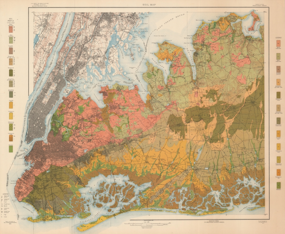
Soil Map New York Hempstead Sheet.
1903 (dated) 27 x 33 in (68.58 x 83.82 cm) 1 : 62500
1903 (dated) 27 x 33 in (68.58 x 83.82 cm) 1 : 62500
Description
A colorful 1903 soil map of New York City and Nassau County, produced by the Bureau of Soils. It provides tremendous detail on the lands in and around the city, crucial information in the fact of break-neck urban development and industrialization.
A Closer Look
Coverage includes Manhattan, the Bronx, Queens, Brooklyn, Nassau County, and parts of New Jersey and Westchester County. A wide variety of soil types are indicated, much of it sandy or gravely, in the latter case brought by glaciers late in the Last Ice Age. Elevation marked by hachures can be seen throughout the city below the street grid, including in cemeteries and parks. Aside from soil information, streets, neighborhoods, parks, cemeteries, reservoirs, railroads (especially the various branches of the Long Island Railroad), aqueducts, bridges (though not the Williamsburg Bridge, opened in 1903), administrative boundaries, and other features are illustrated.The Consolidated Metropolis
Aside from its value as a soil map, this map demonstrates the state of urban sprawl at the time, which was proceeding rapidly. In 1898, New York City as we know it came into existence by consolidating New York (Manhattan and the Bronx) with Queens, Brooklyn, and Staten Island to form the City of New York. At the time, most of Upper Manhattan, Queens, the Bronx, and portions of Brooklyn further from Manhattan, such as East New York and Bensonhurst, had been sparsely inhabited. However, as can be seen here, these areas quickly become heavily developed at the turn of the century, with new city blocks and entire neighborhoods sprouting from the ground in mere months if not weeks. Detailed information on the soils on which these new structures would be built was critical for ensuring the safety and sturdiness of the growing city.Publication History and Census
This map was produced by the Bureau of Soils using U.S. Geological Survey maps as a base. It is dated 1901 at bottom-right but is noted as having been surveyed in 1903 by a team led by Jay Bonsteel. The map was printed by August Hoen in Baltimore. It is noted among the holdings of the University of Wisconsin-Milwaukee, Syracuse University, Brigham Young University, the University of Oklahoma, the University of Texas at Arlington, the University of Chicago, and the University of Illinois at Urbana Champaign.CartographerS
Jay Allen Bonsteel (1873 - 1943) was a soil scientist who conducted dozens of surveys for the Bureau of Soils. The lands he surveyed ranged far and wide within the U.S., but he was especially knowledgeable about lands around New York City and throughout the mid-Atlantic region. He published a series of booklets (circulars) titled Soils of the eastern United States and their use. More by this mapmaker...
August Hoen and Company (fl. c. 1840 - 1981) was a Baltimore based engraving and lithography firm active in the middle part of the 19th century. A. Hoen and Co. was originally founded by Edward Weber under the name 'E. Weber and Company.' Weber died in the early 1850s and his company was taken over by German immigrant August Hoen (18?? - 1886) and his brothers, Henry and Ernest Hoen. As general interest lithographers, the Hoen firm's corpus includes posters, cigar boxes, sheet music covers, and posters as well as maps. They are best known for their pioneering multi-color lithographic techniques. After the death of August Hoen, the business passed on to his son, Albert Hoen. Another son, Earnest A. Hoen, moved to Richmond, Virginia and opened a branch of the firm there where he was granted a charter to produce Civil War era Confederate Currency. Their contributions to the cartographic field are generally in association with engraving and printing work done for Jacob Monk and the U.S. Geological Survey. The Hoen family maintained an active interest in the firm for the next 100 years or so until it finally filed for bankruptcy in 1981. Learn More...
The United States Geological Survey (1878 - Present), aka the U.S.G.S., is a scientific agency of the United States government, which was founded in 1879. USGS scientists study the landscape of the United States, its natural resources, and the natural hazards that threaten it. The organization has four major science disciplines: biology, geography, geology, and hydrology. It is a bureau of the United States Department of the Interior and is the department's only scientific agency. Learn More...
Condition
Very good. Closed margin tears professionally repaired on verso.
References
OCLC 72834460, 18728807.