This item has been sold, but you can get on the Waitlist to be notified if another example becomes available, or purchase a digital scan.
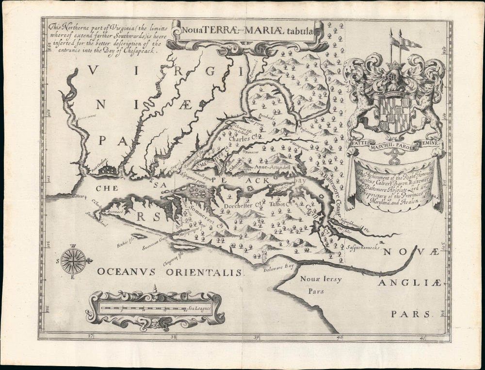
1681 Ogilby Map of Maryland and Virginia - the Lord Baltimore Map
LordBaltimoreMap-ogilby-1671$4,250.00

Title
Nova Terrae-Mariae Tabula.
1671 (undated) 12 x 15 in (30.48 x 38.1 cm) 1 : 1215000
1671 (undated) 12 x 15 in (30.48 x 38.1 cm) 1 : 1215000
Description
This is the 1671 John Ogilby second edition of the 1635 Lord Baltimore map of the Chesapeake Bay - considered the first map of Maryland. Although based on the 1635 map, this Ogilby edition is no slavish copy and includes unique and significant cartography not found elsewhere. It was issued to promote British colonization of Maryland and includes a wealth of unique, relevant detail, including new town sites, ten new county designations, and more defined borders. By all reports, it was successful, with nearly 25,000 English settlers moving to Maryland by 1681.
A Closer Look
Like the 1635 first edition of the Lord Baltimore Map, this map follows the explorations of John Smith and Cyprian Thorowgood. It is oriented to the east, as Maryland would appear to ships navigating from England. Coverage embraces the entirety of the Chesapeake Bay, from the James River (where Jamestown is noted) to where Philadelphia would eventually be founded. It extends inland along the Potomac and other rivers roughly to the vicinity of modern-day Washington, D.C. The heraldic arms of Lord Baltimore appear in the upper right.According to Burden,At first glance this map appears to be a direct copy of the Lord Baltimore's map of 1635. Its engraver is unknown. Close examination reveals advances in cartography, and a unique depiction of the peninsula not found anywhere else in print. The settlements of 'Harvington', 'Calverton' and 'Herrington' are inserted. The definition of the islands in Chesapeake Bay is improved. The 40th parallel, the source of so much dispute in the future, is placed further north. Indeed, this parallel would have taken in the future site of Philadelphia. The Susquehanna River is named, s is the recent colony of New Jersey. Ten Counties are named in the colony. Indeed the map is so advanced that even Cecil County is identified, some three years before its creation! An indication that the Lord Baltimore most probably provided the map. His coat of arms is given prominence top right, the Royal Arms arere moved. It is interesting to note his motto, which could be seen as discriminating now: 'Men, action, women, words'.
The Disputed 40th Parallel
One of the most significant differences between this map and its 1635 predecessor is that the northern border of Lord Baltimore's tract has been pushed northward by several degrees, thus accommodating the site where Philadelphia would eventually be founded. This led to a bitter court conflict with William Penn, whose 1680 grant overlapped with Baltimore's expanded claims. Penn needed access to the Chesapeake Bay and so pushed his claims south, while Lord Baltimore (Charles Calvert) insisted that his lands extended well north - as presented here. Ultimately, the wording of Calvert's grant restricted his claim to 'cultivated lands'. By this time, the Dutch had cultivated lands around Delaware Bay, and the courts determined that these lands fell into the territory granted to Penn.Publication History and Census
This map was published in 1781 by John Olgiby. The map appeared only in the final two editions of John Ogilby's America: Being the Latest, and Most Accurate Description of the New World, published in London in 1671. We note about 12 examples on OCLC. Scarce to the market.Cartographer
John Ogilby (November 17, 1600 - 1676) was a Scottish translator and cartographer. John Ogilby's life seems to be one of extremes, teetering between wealth and poverty, success and failure. Ogilby was born near Edinburgh, Scotland, into a once wealthy family laid low by extreme debt. Struggling with poverty at every turn, Ogilby involved himself in various businesses ranging from dancing master, to actor, to tutor. In 1612, at age 12, Ogilby won a lottery run to advance the colonial interests of Virginia. His winning were sufficient to pay of many of his father's debts and apprentice himself to a dancing master. Ogilby proved a natural and graceful dancer and even made extra money tutoring his fellow apprentices. Starcrossed as he was, Olgiby's dancing career ended when a misstep when a misstep at a masked ball injured his leg and left him lame for live. Afterwards he managed to leverage his contacts in the dance world to secure a position as a dance instructor to the daughters of Sir Ralph Hopton. Hopton struck an immediate friendship with Olgiby and trained him in Military Science. Later Ogilby relocated to Ireland where he worked an as actor and later as Master of Revels. The Irish Rebellion of 1641 again dashed Ogilby's fortunes and forced him to flee Dublin by ship. On the way, the ship sunk but the survivors were rescued and eventually made their way to England, which was then under the strict rule of Oliver Cromwell. Ogilby took refuge at Cambridge where he mastered Greek and Latin. Following the Restoration of Charles II, Ogilby invested in his first major literary venture, a translation of Virgil into English. This work earned him the patronage of Charles II, despite the ridicule of prominent poets Dryden and Pope. Under Royal patronage Ogilby published several volumes relating to the Restoration. In short order he has established a successful London publisher based out of the Whitefriars district. This, unfortunately turned out to be a fateful choice of location as in 1666 the Great Fire of London tore through this are destroying Ogilby's publishing stock, home, and business. Once again Ogilby exhibited a remarkable phoenix-like ability to literally rise from the ashes. Shortly after the Great Fire, he began his most important ventures as a publisher of geographical works. In order to recover from the fire, Ogilby and his grandson were took positions as surveyors commissioned to create a large property map of London. The resultant map of London, "London Survey'd", was published in 1677 and earned Ogilby the honorific "Kings Cosmographer and Geographic Printer". His most famous works are his 1675 Road Atlas of England, Britannia which redefined road mapping, and his 1671 Atlas of the Americas. More by this mapmaker...
Source
Ogilby, J., America: Being the Latest, and Most Accurate Description of the New World, (London: Ogilby) 1671.
Condition
Very good. Trimmed to neatline and laid down on with re-margining matching laid paper, which also stabilizes minor centerfold thinning and possible closed splits. Slight reinstatement of lower right corner border. Presents very clean. Priced accordingly.
References
Pritchard, M. B. and Taliaferro, H., Degrees of Latitude, #12. Burden, P., The Mapping of North America, #240. Burden, P., The Mapping of North America II, #417. OCLC 381176463.