
This item below is out of stock, but another example (left) is available. To view the available item, click "Details."
Details
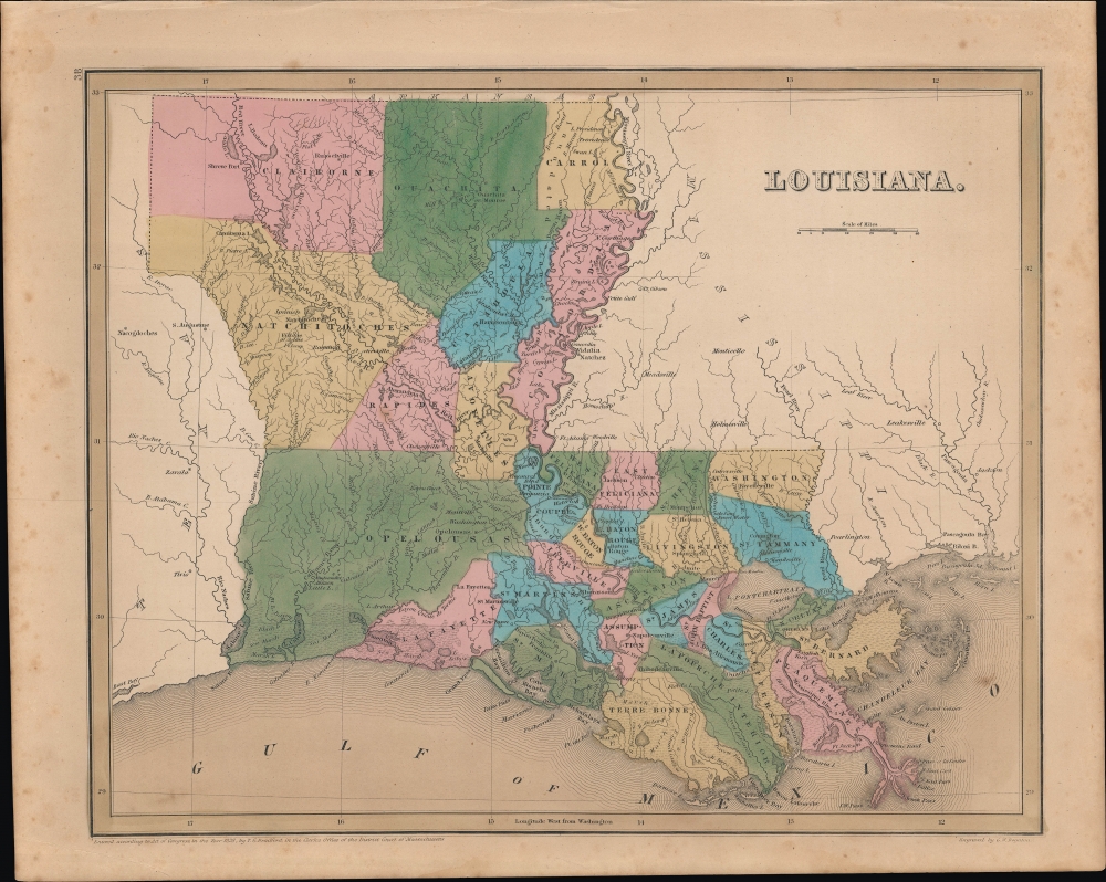
1846 Bradford Map of Louisiana
1846 (dated) $400.00
1838 Bradford Map of Louisiana
Louisiana-bradford-1838$200.00

Title
Louisiana.
1838 (dated) 11.5 x 14.25 in (29.21 x 36.195 cm) 1 : 1700000
1838 (dated) 11.5 x 14.25 in (29.21 x 36.195 cm) 1 : 1700000
Description
This is Thomas Bradford's 1838 hand-colored map of Louisiana, which appeared in his Universal Illustrated Atlas.
As is the case with most of the maps in Bradford's Universal Illustrated Atlas, the nascent railroad network of the United States is illustrated. Several of the railroads seen here traveled very short routes; most were less than thirty miles. The Alexandria and Cheneyville Railroad, for example, stretched twenty-eight miles, while the Pontchartrain Railroad, illustrated but unlabeled here, connected the Faubourg Marigny neighborhood of New Orleans with Milneburg (later absorbed by New Orleans) on the lake's shore.
A Closer Look
Highly detailed, each contemporary parish of Louisiana is illustrated, labeled, and shaded a different color to allow for easy differentiation. Numerous towns and villages are labeled, including Baton Rouge and New Orleans, along with canals and other waterways. The mighty Mississippi River winds its way down the map, forming part of the border between Louisiana and Mississippi, along with myriad other rivers and creeks.As is the case with most of the maps in Bradford's Universal Illustrated Atlas, the nascent railroad network of the United States is illustrated. Several of the railroads seen here traveled very short routes; most were less than thirty miles. The Alexandria and Cheneyville Railroad, for example, stretched twenty-eight miles, while the Pontchartrain Railroad, illustrated but unlabeled here, connected the Faubourg Marigny neighborhood of New Orleans with Milneburg (later absorbed by New Orleans) on the lake's shore.
The West Feliciana Railroad
Among the railroads displayed here is the West Feliciana Railroad, between St. Francisville, Louisiana and Woodville, Mississippi. It was the first interstate and first standard gauge rail line in the country when it was chartered in 1831. When it was abandoned in 1978, the twenty-eight-mile line between Bayou Sara and Woodville was the oldest standard-gauge line in the nation. These short railroads were constructed to get cotton, the all-powerful export of the Antebellum South, from the plantations and mills to the Mississippi River, and were a welcome (if expensive) alternative to the poorly constructed roads.The 'Nashville Railroad'
Not to be confused with the later Louisville and Nashville Railroad, the impressive-looking line extending northwards from New Orleans, labelled here as the 'Nashville Railroad,' is the New Orleans and Nashville Railroad, which was only chartered in 1837. Despite its grand ambitions, only a few miles of track on this line were ever built, thanks to the Panic of 1837. Moreover, in the years following the panic there was limited enthusiasm for financing such a line in New Orleans, as riverboats on the Mississippi River already provided a quick and reliable means of transportation to points north.Publication History and Census
This map was engraved by George Boynton and published in the 1838 edition of Bradford's A Universal Illustrated Atlas.CartographerS
Thomas Gamaliel Bradford (1802 - 1887) was born in Boston, Massachusetts, where he worked as an assistant editor for the Encyclopedia Americana. Bradford's first major cartographic work was his revision and subsequent republishing of an important French geography by Adrian Balbi, Abrege de Geographie published in America as Atlas Designed to Illustrate the Abridgment of Universal Geography, Modern and Ancient. Afterwards Bradford revised and expanded this work into his own important contributions to American cartography, the 1838 An Illustrated Atlas Geographical, Statistical and Historical of the United States and Adjacent Countries. Bradford's cartographic work is significant as among the first to record Texas as an independent nation. In his long career as a map publisher Bradford worked with William Davis Ticknor of Boston, Freeman Hunt of New York, Charles De Silver of Philadelphia, John Hinton, George Washington Boynton, and others. We have been able to discover little of Bradford's personal life. More by this mapmaker...
George Washington Boynton (fl. c. 1830 - 1850) was a Boston based cartographer and map engraver active in the first half of the 19th century. Boynton engraved and compiled maps for numerous publishers including Thomas Bradford, Nathaniel Dearborn, Daniel Adams, and S. G. Goodrich. His most significant work is most likely his engraving of various maps for Bradford's Illustrated Atlas, Geographical, Statistical, and Historical, of the United States and the Adjacent Countries and Universal Illustrated Atlas. He also engraved for the Boston Almanac. In 1835, Boynton is listed as an employee of the Boston Bewick Company, an engraving, stereotype, and printing concern based at no. 47 Court Street, Boston. Little else is known of his life. Learn More...
Source
Bradford, T. G. and Goodrich, S. G., A Universal Illustrated Atlas, exhibiting a Geographical, Statistical, and Historical view of the World, (Boston: Charles D. Strong) 1838.
The Universal Illustrated Atlas is one of the great American atlases of the first half of the 19th century. The atlas was first published in 1838 under the imprint of Charles D. Strong. It replaced and superseded Bradford's earlier smaller format Illustrated Atlas, Geographical, Statistical, and Historical, of the United States and the Adjacent Countries. Numerous reissues of the Universal Illustrated Atlas followed until about 1848. Although there are minor variations between the editions, most contain about 50 maps, the majority of which focus on the United States. Bradford's atlases are significant for recording North America during the Republic of Texas Era. In later editions, particularly the 1846 edition, Bradford illustrates the boom in railroad construction, possibly with the idea that his maps would aid travelers in planning journeys by rail. It was compiled by Thomas Gamaliel Bradford and Samuel Griswold Goodrich with most of the plates engraved by George Washington Boynton (fl. c. 1830 - 1850). Other contributors include Thomas Gordon (1778 - 1848), Fielding Lucas Jr. (1781 - 1854), Samuel Edward Stiles (1844 - 1901), Sherman and Smith (fl. c. 1829 - 1855), and Horace Thayer (1811 - c. 1874).
Condition
Very good. Light foxing and soiling around margins.
References
Rumsey 0089.034.