This item has been sold, but you can get on the Waitlist to be notified if another example becomes available, or purchase a digital scan.
1780 Bonne and Raynal Map of Florida, Louisiana, and the Carolinas
Louisiane2-bonne-1780$125.00

Title
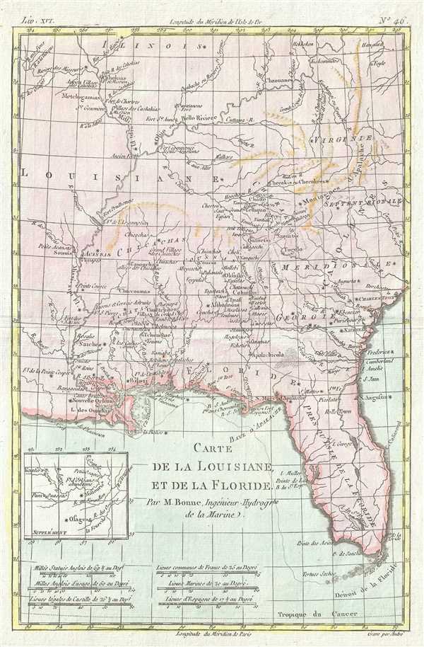
Carte de la Louisiane et de la Floride.
1780 (undated) 13.5 x 9 in (34.29 x 22.86 cm) 1 : 6250000
1780 (undated) 13.5 x 9 in (34.29 x 22.86 cm) 1 : 6250000
Description
This is a 1780 Rigobert Bonne and Guillaume Raynal map of Florida, Louisiana, and the Carolinas. The map depicts the region that corresponds to the modern-day states of Florida, Georgia, Alabama, Arkansas, Kentucky, Tennessee, North Carolina, South Carolina, Virginia and Louisiana. Of the colonies, Florida, Georgia, South Carolina, North Carolina, and Virginia are illustrated, each of which is also labeled. Coastal settlements, such as New Orleans (Nouvelle Orléans), Biloxi, Pensacola, St. Augustine, Savannah, and Charleston (Charles Town) are also labeled. Considerable detail is included throughout the interior that had only been tenuously explored up to this point, naming numerous American Indian tribes and villages including Apalachicola, Echicachae, Chaccoumas, Acansas, and many others. At this point in the history of the New World, Florida was still part of the Spanish Empire, while the other four states were fighting for their independence from England in the American Revolutionary War. An inset in the lower left quadrant focuses on the upper Missouri River, which was of interest at the time as a possible water route to the Pacific.
Drawn by R. Bonne for G. Raynal's Atlas de Toutes les Parties Connues du Globe Terrestre, Dressé pour l'Histoire Philosophique et Politique des Établissemens et du Commerce des Européens dans les Deux Indes.
Drawn by R. Bonne for G. Raynal's Atlas de Toutes les Parties Connues du Globe Terrestre, Dressé pour l'Histoire Philosophique et Politique des Établissemens et du Commerce des Européens dans les Deux Indes.
CartographerS
Rigobert Bonne (October 6, 1727 - September 2, 1794) was one of the most important French cartographers of the late 18th century. Bonne was born in Ardennes à Raucourt, France. He taught himself mathematics and by eighteen was a working engineer. During the War of the Austrian Succession (1740 - 1748) he served as a military engineer at Berg-op-Zoom. It the subsequent years Bonne became one of the most respected masters of mathematics, physics, and geography in Paris. In 1773, Bonne succeeded Jacques-Nicolas Bellin as Royal Cartographer to France in the office of the Hydrographer at the Depôt de la Marine. Working in his official capacity, Bonne compiled some of the most detailed and accurate maps of the period - most on an equal-area projection known erroneously as the 'Bonne Projection.' Bonne's work represents an important step in the evolution of the cartographic ideology away from the decorative work of the 17th and early 18th century towards a more scientific and practical aesthetic. While mostly focusing on coastal regions, the work of Bonne is highly regarded for its detail, historical importance, and overall aesthetic appeal. Bonne died of edema in 1794, but his son Charles-Marie Rigobert Bonne continued to publish his work well after his death. More by this mapmaker...
Guillaume Thomas Raynal (April 12, 1711 - March 6, 1796) was a French writer, philosopher, and historian active during the Enlightenment. Raynal was educated as a Jesuit, but left the order for unknown reasons, and moved to Paris where he dedicated himself to the production of a number of minor but popular historical works. Raynal's histories opened doors to elite social and artistic circles where he met and befriended various members of the Philosophe Coteries. Raynal's most important work is generally considered to be a 1770 collaboration with Diderot and others entitled, L'Histoire philosophique et politique des établissements et du commerce des Européens dans les deux Indes. Some of the philosophical ideas developed in the book drew negative attention from the authorities who banned the book and posted a notice for the arrest of its authors. Raynal fled to Berlin and later to St. Petersburg, where he lived for a number of years before returning to France in 1787. Though not a cartographer Raynal's name is often attached to several Atlases by Rigobert Bonne, from whom he composed the text. Learn More...
Source
Raynal, G., Atlas de Toutes les Parties Connues du Globe Terrestre, Dressé pour l'Histoire Philosophique et Politique des Établissemens et du Commerce des Européens dans les Deux Indes, 1780.
Condition
Very good. Even overall toning. Blank on verso.
References
OCLC 5412453.