1803 Blondeau Map of Louisiana and West Florida
LouisianeFloride-blondeau-1803-2$2,000.00

Title
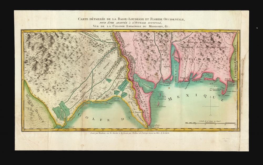
Carte Détaillée de la Basse-Louisiane et Floride Occidentale, pour étre adaptée à l'Ouvrage intitulé, Vue da la Colonie Espagnol due Mississipi, et c.
1803 (undated) 10 x 15.5 in (25.4 x 39.37 cm) 1 : 220000
1803 (undated) 10 x 15.5 in (25.4 x 39.37 cm) 1 : 220000
Description
This is Alexandre's Blondeau's exceptional 1803 map of Spanish-administered Louisiana and West Florida, issued for Pierre-Louis Berquin Duvallon's travel narrative, Vue de la Colonie Espagnole due Mississipi. It is one of the best maps to capture the Gulf littoral during the Post-American Revolutionary War Spanish period on the cusp of the Louisiana Purchase.
Word of the retrocession did not reach U.S. Diplomatic circles until 1801, and then only in rumors. Fearing that France would renege on Spanish-American treaties guaranteeing the United States access to the Mississippi River and rights of deposit in New Orleans, then President Thomas Jefferson initiated diplomatic talks with French Emperor Napoleon Bonaparte to acquire New Orleans. Talks initially languished as Napoleon's troops attempted to suppress the revolution on Saint-Domingue (Haiti), which they considered to be the more significant territory. When French forces were soundly defeated by the Haitian revolutionary leader Jean-Jacques Dessalines in 1802, Napoleon relegated Louisiana to a redundancy and agreed to the Louisiana Purchase, transferring the territory to the United States on December 20, 1803.
A Closer Look
The map was engraved in Paris by Alexandre Blondeau. It captures the southern part of Spanish Louisiana and West Florida. Centered on the Mississippi River and New Orleans, coverage embraces from what is here named the 'Rio de San Marco ou de Colorado', likely the Sabine River, and just to the east, Lake Calcasieu (Lacs des Cono-Kosses), east past Mobile Bay and Pensacola, as far as the Apalachicola River (Rio des Apalaches). The territory is divided by the Mississippi River into 'Basse-Louisiane' and 'Floride Occidentale'. New Orleans, Baton Rouge, Mobile, Pensacola, Poste de Plaquemine (Plaquemines Parish), and Fort Apalache are named.Historical Context
By the time Duvallon arrived in New Orleans in 1800, Spain had already retroceded Louisiana to France through the Third Treaty of San Ildefonso. However, the agreement was a state secret in both countries and there would have been little evidence of the exchange in New Orleans, which, according to the treaty, continued to be governed by Spain through 1803.Word of the retrocession did not reach U.S. Diplomatic circles until 1801, and then only in rumors. Fearing that France would renege on Spanish-American treaties guaranteeing the United States access to the Mississippi River and rights of deposit in New Orleans, then President Thomas Jefferson initiated diplomatic talks with French Emperor Napoleon Bonaparte to acquire New Orleans. Talks initially languished as Napoleon's troops attempted to suppress the revolution on Saint-Domingue (Haiti), which they considered to be the more significant territory. When French forces were soundly defeated by the Haitian revolutionary leader Jean-Jacques Dessalines in 1802, Napoleon relegated Louisiana to a redundancy and agreed to the Louisiana Purchase, transferring the territory to the United States on December 20, 1803.
Love Hate Affair with New Orleans
Duvallon had a love-hate relationship with Louisiana in general, and New Orleans specifically. His initial low opinion was likely spurred by his run-ins with the law regarding his importation of illegal Haitian slaves. He dwells on New Orleans over several chapters, which he describes as a ramshackle city with streets little better than open sewers. He seems to have been both scandalized and fascinated by the city's nightlife, calling the citizens amoral drunks bereft of education and manners, given to lewd dancing and nonstop gambling. He was particularly bothered by the free mixing of the races, as well as freemen and slaves. However, given the amount of pen-time he dedicates to these topics, it is clear he spent a good deal of time engaged in such activities.Publication History and Census
This map was engraved in Paris by Alexandre Blondeau for Duvallon's Vue de la Colonie Espagnole du Mississipi ou des provinces de Louisiane et Floride Occidentale en l’an 1802. We see no cataloging of the separate map, but the book is well-represented institutionally. Scarce to the market.CartographerS
Pierre-Louis Berquin Duvallon (1769 - 1814) was a French sugar planter and procureur du roi in French Santo Domingo before the Haitian Revolution (1791 - 1804). Berquin-Duvallon was born in Santo Domingo. In 1793 in the Revolution he fled to Baltimore - specifically as Maryland allowed him to bring and keep his slaves. (Louisiana, of note, did not allow the import of Haitian slaves after the 1791, for fear they would spread revolutionary sentiment.). In 1800, he travled to New Orleans, where he found trouble with the law as he brought his illegal Haitian slaves. Nonethless, he traveled through Louisiana, and purchased a plantation on the Tchoupitoulas Coast. It was there that he wrote the travel account for which he is best remembered, Vue de la Colonie Espagnole du Mississipi ou des provinces de Louisiane et Floride Occidentale en l’an 1802. More by this mapmaker...
Alexandre Blondeau (fl. c. 1799 - 1828) was a French line engraver based in Paris. In 1816 during the reign of Louis XVIII, he was appointed 'Graveur du Roi' and 'Premier Graveur du Dépot de la Guerre'. His apprentices include the topographical engraver Pierre Léonard Dandeleux (1783 - 1850). Learn More...
Source
Duvallon, Pierre-Louis Berquin, Vue de la colonie Espagnole du Mississipi, ou des provinces de Louisiane et Floride Occidentale, en l'année 1802 de Louisiane et Floride occidentale, en l'année 1802, par un observateur résidant sur les lieux, (Paris: Imprimerie Expéditive) 1803.
Condition
Very good. Mended tear at insertion point. Right margin reinstated at insertion point.
References
OCLC 494622744. Howes, W., U.S.iana (1650-1950): A Selective Bibliography in which are Described 11,620 Uncommon and Significant Books Relating to the Continental Portion of the United States, #B389. Sabin, J., Biblioteca Americana. A Dictionary of Books Relating to America, from its Discovery to Present Time, (29 vols) #4962. Streeter, T. W., The celebrated collection of Americana formed by the late Thomas Winthrop Streeter, #1530. Leclerc, C., Bibliotheca Americana, #1038.