
1995 Mapeasy Pictorial Map of Lower Manhattan, New York City


This item has been sold.
MapEasy's Guide to Lower Manhattan.
The Revitalization of Manhattan.
Choose a Collection:
This Item
Enquire
The Revitalization of Manhattan.
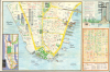
This is a c. 1995 pictorial map of Lower Manhattan published by the firm MapEasy. It presents the city in the early part of the Giuliani years, when its reputation recovered after having a negative image for several decades prior.A Closer Look
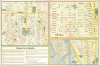
This highly informative work includes three maps on the recto and four on the verso. The main map on the recto covers Manhattan south of Chambers Street, including Wall Street, City Hall, Castle Clinton, and the Ellis Island / Statue of Liberty Ferry, the Staten Island Ferry Terminal, and the World Trade Center, tragically destroyed less than a decade later in the September 11 attacks. Major attractions are illustrated, while restaurants are labeled in red text and other businesses in green. An inset map at the bottom-right depicts Soho in similar detail, and a map of the New York City Subway system in Manhattan and the South Bronx occupies the bottom-left. The verso includes maps of Greenwich Village, Chelsea, and Tribeca, along with an overview map of Lower Manhattan indicating the location of the various neighborhoods depicted. Text also provides helpful information on transportation and the miseries of Manhattan in the summertime.Historical Context
The mid-1990s marked a pivotal turning point in New York City's history, as it transitioned from an era of high crime and urban decay into a period of revitalization. Following the peak of the crack epidemic and record-high murder rates in 1990, the administration of Mayor Rudy Giuliani, who took office in 1994, implemented strict policing, rooted in the 'Broken Windows' theory, focused on cracking down on minor infractions like graffiti and turnstile jumping to foster a sense of public order. The city saw a dramatic drop in violent crime, and this newfound safety began to reshape New York's national reputation. Tourism increased by 30 percent over the decade, and the city came to be seen as a model of urban governance rather than a poster child for mismanagement and urban decay.Publication History and Census
This map was prepared by the firm MapEasy. It is undated. Although the subway map is copyrighted 1993, the entire work is cataloged as 1995 according to its ISBN. Several editions were published by MapEasy between roughly 1992 and 2013. The present edition is cataloged by ten institutions in the OCLC.Condition
Good. Wear along original fold lines. Old tape repairs to fold separations on both sides. Map of Lower Manhattan on recto. Maps of Greenwich Village, Chelsea, and Tribeca on verso.
References
OCLC 37986210, 45100976, 37986207.