This item has been sold, but you can get on the Waitlist to be notified if another example becomes available, or purchase a digital scan.
1880 Eldridge Nautical Chart of Cape Ann and Marblehead, Massachusetts
LynnHalibutPoint-eldridge-1880$325.00

Title
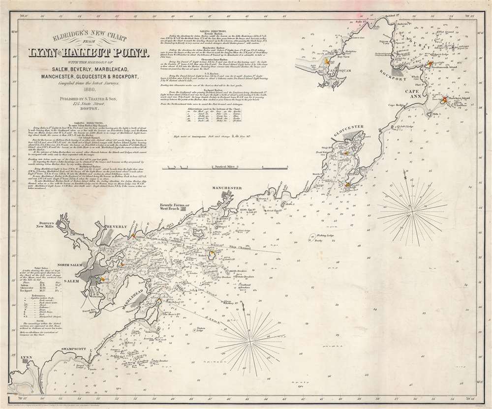
Eldridge's New Chart From Lynn to Halibut Point. With the Harbors of Salem, Beverly, Marblehead, Manchester, Gloucester, and Rockport.
1880 (dated) 18 x 21.75 in (45.72 x 55.245 cm) 1 : 64768
1880 (dated) 18 x 21.75 in (45.72 x 55.245 cm) 1 : 64768
Description
This is an 1880 George Eldridge nautical chart or maritime map of Cape Ann and Marblehead, this embracing the Massachusetts North Shore. Focusing on the Massachusetts coast from Halibut Point and Annisquam to Lynn, the chart identifies important navigational landmarks as well as hazards. Cities and towns, including Rockport, Gloucester, Manchester, Beverly, Salem, and Marblehead, appear. Yellow and red manuscript notations mark coastal lights. Coastal features, such as points, heads, bays, and coves, are marked. Islands are illustrated. Depth soundings are indicated along the coast, with ledges, banks, shoals, and other hazards noted as well. Navigation instructions for approaching Salem, Beverly, and Marblehead are present as well. Detailed sailing directions are included in the upper left corner.
Publication History and Census
This map was created by George Eldridge, engraved by George Boynton, and published by Samuel Thaxter Cushing in 1880. This is the only known cataloged example of the 1880 edition of this chart. We have located only a handful of surviving examples dating both before and after the present edition.CartographerS
George Eldridge (November 27, 1821 - August 23, 1900) and his son George Washington Eldridge (1845 - 1914) were American makers of nautical charts and Pilot Books active in the late 19th century. George Eldridge was a Cape Cod fisherman known locally as an excellent ship's pilot. While recuperating from an injury in 1851, Eldridge drew his first nautical chart. The chart proved popular, and its success led Eldridge to pursue a career in hydrography - the science of mapping the sea with a special focus on navigation. Eldridge produced numerous subsequent maps and is credited with issuing some of the earliest accurate nautical charts of the American Atlantic coast. In time George Eldridge passed his thriving business on to his son, George Washington Eldridge, who continued to produce beautiful and practical maritime charts until 1924.Though most of Eldridge's charts were loosely based on U.S. Coast Survey work, they proved popular with navigators. The Eldridges possessed a talent, shared by both father and son, for distilling the often convoluted Coast Survey maps into practical nautical charts for the working mariner. From 1875, in addition to large format independently issued nautical charts, Eldridge also issued annual editions of Eldridge's Tide and Pilot Book and The Book of Harbor Charts. The Eldridge offices were located at 103 State St. Boston, Massachusetts. After the deaths of George and George Washington Eldridge, the firm passed into the hands of the latter's widow Sydna, and son-in-law, Wilfrid O. Wight. Wight's son and subsequent generations have continued to publish the Eldridge Tide and Pilot Book down to the present. More by this mapmaker...
George Washington Boynton (fl. c. 1830 - 1850) was a Boston based cartographer and map engraver active in the first half of the 19th century. Boynton engraved and compiled maps for numerous publishers including Thomas Bradford, Nathaniel Dearborn, Daniel Adams, and S. G. Goodrich. His most significant work is most likely his engraving of various maps for Bradford's Illustrated Atlas, Geographical, Statistical, and Historical, of the United States and the Adjacent Countries and Universal Illustrated Atlas. He also engraved for the Boston Almanac. In 1835, Boynton is listed as an employee of the Boston Bewick Company, an engraving, stereotype, and printing concern based at no. 47 Court Street, Boston. Little else is known of his life. Learn More...
Samuel Thaxter and Son (fl. 1792 - 1916). Samuel Thaxter (1769 - 1842) is the founder of a Boston dynasty of manufacturers of mathematical instruments and nautical charts. He founded the firm in 1792 and is first referenced in the 1796 Boston Directory. Around 1822 he incorporated his son, Joseph H. Thaxter (1801 - 1835), into the business renaming it 'Samuel Thaxter and Son'. The firm would retain this name for the remainder of its existence. This successful business was subsequently passed to Joseph H. Thaxter's son, Samuel Thaxter Cushing (1821 - 1882), in 1843. It was Thaxter Cushing who developed the firm's publishing arm, partnering with the Boston nautical chart maker George Eldridge. They are best known for 13 large format blueback charts focusing on the east cost of the United States published in the second half of the 19th century. They also published numerous smaller maps and pilot books. After Thaxter Cushing died the firm was taken over by his widow, Abby C. Cushing, who managed it until 1905. It was subsequently managed by Herbert Risteen Starratt and continued to be registered in the Boston Directory until about 1916. Learn More...
Condition
Good. Closed margin tears professionally repaired on verso. Light staining.