1918 War Office Map of Macao
Macao-waroffice-1918$850.00

Title
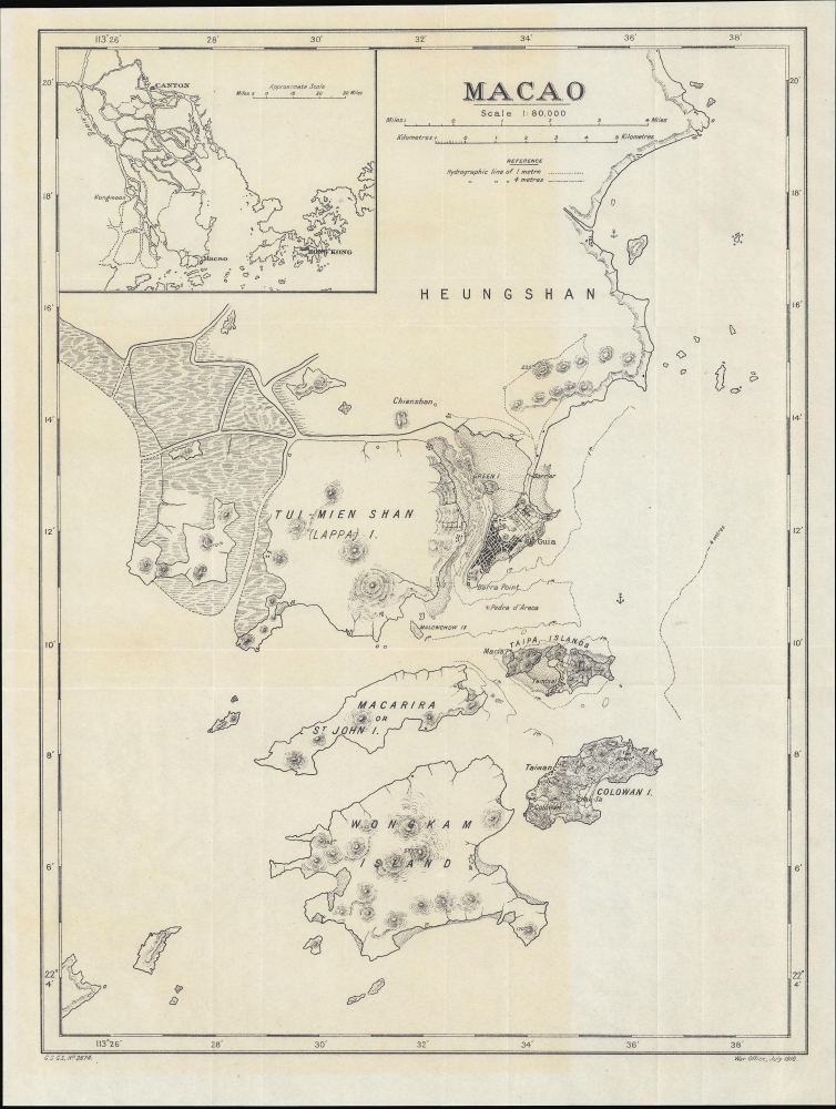
Macao. G.S. G.S., No. 2874.
1918 (dated) 16.75 x 12.5 in (42.545 x 31.75 cm) 1 : 80000
1918 (dated) 16.75 x 12.5 in (42.545 x 31.75 cm) 1 : 80000
Description
A scarce World War I-era map of the Portuguese colony of Macao and environs, produced by the British War Office in 1918.
These projects were set on a collision course, with Portugal decidedly at a disadvantage, but political chaos within China and the First World War delayed Macao's reckoning. Also, Sun Yat-sen (Sun Zhongshan), the putative founder of the Chinese Republic, was somewhat well-disposed towards Macao, having been born nearby and having used the territory to raise funds and weapons for his revolutionary movement in the years before the fall of the Qing Dynasty. Subsequent Chinese leaders were either too weak to make a move on Macao, or, like Sun, clever enough to recognize that the territory presented opportunities (for trade, smuggling, capital, currency, etc.) that outweighed whatever glory would be gained from reasserting Chinese sovereignty over it. Only when this logic no longer applied, as other outlets to the world were opened along the Chinese coast in the 1980s, did China press for a return of the territory to Chinese rule.
A Closer Look
The Macao Peninsula, constituting the main part of Portugal's long-established colony off the South China coast, sits at center towards right, reflecting urban development. Fortifications and strategic points, including the historic Guia Fortress, are indicated. Other details including topography, individual buildings, and, on water, shoals, anchorages, hazards, and depths, are noted, with greater detail on the Macao Peninsula and the other islands included in the colony (Taipa, Coloane or Colowan, Green Island). Nearby islands administered as part of Guangdong Province, as well as the Chinese mainland (Xiangshan County, here as Heungshan), are similarly detailed. At top-left, an inset map displays the location of Macao relative to Canton (Guangzhou), Hong Kong, and the Pearl River Delta as a whole.Historical Context
Portugal's colony of Macao was the longest-lasting foreign territory on Chinese soil, existing for more than 400 years from 1577 - 1999, despite, or perhaps because, Portugal exercised very weak control. As with other parts of Portugal's colonial empire, efforts were made in the 19th-century to shore up or even expand territorial claims and implant a modern bureaucratic administration. In the case of Macao, this included annexing the islands of Taipa and Coloane south of the Macao Peninsula, which continued to be disputed by Chinese authorities for decades, and building a causeway to Green Island (Ilha Verde). Incidentally, both Portugal and China transitioned from monarchies to republics at nearly the same time, between 1910 and 1912, and both sought to affirm their national projects by enhancing sovereignty over disputed territory: Portugal throughout its empire and China over foreign concessions, colonies, and treaty ports around its periphery.These projects were set on a collision course, with Portugal decidedly at a disadvantage, but political chaos within China and the First World War delayed Macao's reckoning. Also, Sun Yat-sen (Sun Zhongshan), the putative founder of the Chinese Republic, was somewhat well-disposed towards Macao, having been born nearby and having used the territory to raise funds and weapons for his revolutionary movement in the years before the fall of the Qing Dynasty. Subsequent Chinese leaders were either too weak to make a move on Macao, or, like Sun, clever enough to recognize that the territory presented opportunities (for trade, smuggling, capital, currency, etc.) that outweighed whatever glory would be gained from reasserting Chinese sovereignty over it. Only when this logic no longer applied, as other outlets to the world were opened along the Chinese coast in the 1980s, did China press for a return of the territory to Chinese rule.
Publication History and Census
This map was produced by the General Staff Geographical Section (G.S.G.S. at bottom-left) in 1918 by the British War Office, who no doubt were primarily concerned with their colony nearby at Hong Kong. The map is quite rare, only being independently cataloged among the holdings of the British Library and has no known history on the market. It appears to have been produced as a reference companion to the Macao section of Handbooks Prepared Under the Direction of the Historical Section of the Foreign Office - No. 81 (H. M. Stationary Office, 1920).Cartographer
The British War Office (1857 - 1964) was a department of the British Government responsible for the administration of the Royal Army until 1964, when its functions were transferred to the Ministry of Defense. The War Office was to the Royal Army what the Admiralty was to the Royal Navy, and later, the Air Ministry. Within the War Office, the General Staff Topographical Section was responsible for thousands of maps issued for British intelligence and military use. The Topographical Section was renamed Geographical Section in April 1907. Many, once their military use passed, were offered through licensed agents to the general public. The sole London agent for War Office material was Edward Stanford. More by this mapmaker...
Condition
Very good. Light wear along original folds.
References
OCLC 497586425. Cunha, L., 'Macau Between Republics: Neither War nor Peace (1914-1918)' e-Journal of Portuguese Studies Vol. 15, No. 1 (2017).