This item has been sold, but you can get on the Waitlist to be notified if another example becomes available, or purchase a digital scan.
1630 De Laet Map of Patgonia, Tierra del Fuego and the Strait of Magellan
Magellanica-delaet-1630$475.00

Title
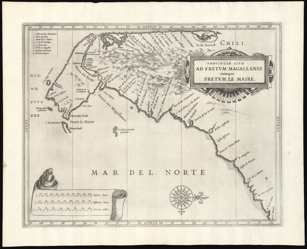
Provinciae Sitae Ad Fretum Magallanis itemque Fretum Le Maire.
1630 (undated) 11 x 14.25 in (27.94 x 36.195 cm) 1 : 7400000
1630 (undated) 11 x 14.25 in (27.94 x 36.195 cm) 1 : 7400000
Description
This is Johannes de Laet's 1630 map of southern South America, from the southern bank of the Rio de la Plata in the north to Tierra del Fuego in the south. It was the work of the official chartmaker of the Dutch West India Company, Hessel Gerritsz; his was the best charting of the region available. It first appeared in De Laet's 1626 Beschrijvinghe van West-Indien with a Dutch title, Provincien van de Straet van Magallanes, ende vande Straet Le Maire. (The title and the labels for the three scales were altered on the copperplate for the 1633 Latin-text edition.)
The map's main impact would have been its portrayal of Tierra del Fuego, the Strait of Magellan, and the Strait of Le Maire. Tierra del Fuego as a large island (in reality, the western parts of the island depicted here are an archipelago.) The island's northern limits are marked with the Strait of Magellan. The Pacific coast immediately to the north is sufficiently detailed that a table of place names (keyed with numbers to the map) was required to fit them. The discovery of that passage in 1522 by the Portuguese Ferdinand Magellan opened the age of global discovery. It was, however, left to the Dutch explorers Le Maire and Schouten during their 1615-1617 circumnavigation to definitively show Tierra del Fuego to be an island, rather than part of a massive Terra Australis. Part of their goal being to circumvent the Portuguese hold on the Strait of Magellan, Le Maire and Schouten were able to sail around Cape Horn and pass to the Pacific without using the Portuguese route. In doing so, they passed through the strait that took Le Maire's name - between Tierra del Fuego and what they termed Staten Eylandt. Their goal had been to circumvent a monopoly over trade passing through the Strait of Magellan: not that of the Portuguese, but that of the Dutch West India company. The company initially attempted to suppress knowledge of the new strait, with the laughable result that Blaeu - then an official chartmaker for the VOC - could not include the new information on his maps while his competitor Hondius did without compunction as early as 1618. The VOC relented when Blaeu complained, and indeed De Laet's book - an official VOC publication - included the present map, with its state-of-the-art charting.
A Closer Look
Gerritsz' work is more a chart than a map; there is minimal interior detail, as from attractively-engraved mountains. His treatment of the coastline nevertheless set the standard for the first part of the 17th century. The Atlantic coast spans from the Cap. San Anrtonio in the north - the bank of the Rio de la Plata. The mapping of the Pacific coast reaches as far north as the Chiloé Archipelago, including the Province of Ancud, and the city of Castro (Chile's third oldest city in continuous existence).The map's main impact would have been its portrayal of Tierra del Fuego, the Strait of Magellan, and the Strait of Le Maire. Tierra del Fuego as a large island (in reality, the western parts of the island depicted here are an archipelago.) The island's northern limits are marked with the Strait of Magellan. The Pacific coast immediately to the north is sufficiently detailed that a table of place names (keyed with numbers to the map) was required to fit them. The discovery of that passage in 1522 by the Portuguese Ferdinand Magellan opened the age of global discovery. It was, however, left to the Dutch explorers Le Maire and Schouten during their 1615-1617 circumnavigation to definitively show Tierra del Fuego to be an island, rather than part of a massive Terra Australis. Part of their goal being to circumvent the Portuguese hold on the Strait of Magellan, Le Maire and Schouten were able to sail around Cape Horn and pass to the Pacific without using the Portuguese route. In doing so, they passed through the strait that took Le Maire's name - between Tierra del Fuego and what they termed Staten Eylandt. Their goal had been to circumvent a monopoly over trade passing through the Strait of Magellan: not that of the Portuguese, but that of the Dutch West India company. The company initially attempted to suppress knowledge of the new strait, with the laughable result that Blaeu - then an official chartmaker for the VOC - could not include the new information on his maps while his competitor Hondius did without compunction as early as 1618. The VOC relented when Blaeu complained, and indeed De Laet's book - an official VOC publication - included the present map, with its state-of-the-art charting.
Nodal Expedition
The presence off the west coast of Tierra del Fuego of the Isla de Diego Ramires and the Entrada de St. Sebastian reveal knowledge of the 1619 Nodal Expedition. This voyage, sponsored by King Philip III of Spain, was intended to confirm the by-then famous discoveries of Le Maire and Schouten. Led by brothers Bartolome and Gonzalo Garcia de Nodal, the expedition lasted from September 27, 1618 to July 7, 1619, having achieved its goals with no loss of life. Despite the notoriously secretive Spanish bureaucracy, some detail was able to reach the Dutch to be preserved here.Publication History
This map is one of a series of North American maps that accompanied Johannes de Laet's Nieuwe Wereldt ofte Beschrijvinghe van West-Indien. It was engraved by Hessel Gerritsz, who was the official cartographer to the Dutch East India Company from 1617. We are aware of three states. A first state, with the Dutch title and scale notations, appeared in the 1626 and 1630 editions of the book. The Latin edition, published by Elzeviers in 1633, included the map with these elements translated; some, but not all, of this edition include a mark to the copperplate inland between Cabo de Andres and C. das arenas gordas. At some point during that print run the mark was burnished out, so creating a third state found in some examples of the 1633 edition and all examples of the 1640. The present example, with the translated title and the plate scuff, is of the 1633 second state. De Laet's book is well represented in institutional collections. The separate map in its first state is listed in OCLC eleven times. There are only three separate examples of the second or third states, which are not distinguished from one another in OCLC. These are held by the Bayerische Staatsbibliothek, the Biblioteca Nacional de Espana, the British Library.CartographerS
Johannes de Laet (1581 – December 15, 1649) was a Dutch businessman and cartographer active in Leiden during the early 17th century. De Laet was a Flemish Protestant born in Antwerp to a prosperous merchant family in the cloth trade. When Antwerp fell to the Catholic Spanish in August of 1585, he and his family fled to the northern Netherlands. At the University of Leiden, he studied Theology and Philosophy, matriculating in 1597. In 1603 he relocated to London, where he acquired denizenship, an early type of citizenship and married. His Anglo-Dutch wife died shortly afterward and he returned to Leiden, where he married again. He cleverly invested in Dutch land reclamation projection and the overseas trade, becoming extremely wealthy. In 1620, he became a founding director of the Dutch West Indies Company, a position he held until his death. His most important cartographic work, Nieuwe Wereldt ofte Beschrijvinghe van West-Indien has been hailed by the map historian Phillip Burden as 'arguably the finest description of the Americas published in the 17th century. It contained several seminal maps of the Americas that significantly advanced cartographic perspectives on the region and served as a foundational work for subsequent cartographers. De Laet died in Den Haag (The Hague) in 1649. More by this mapmaker...
Hessel Gerritsz (1581 – September 4, 1632) was a Dutch engraver, cartographer, and publisher active in Amsterdam during the late 16th and early 17th centuries, among the most preeminent Dutch geographers of the 17th century. He was born in Assum, a town in northern Holland in 1581. As a young man he relocated to Alkmaar to accept an apprenticeship with Willem Jansz Blaeu (1571-1638). He followed Blaeu to Amsterdam shortly afterwards. By 1610 he has his own press, but remained close to Blaeu, who published many of his maps. In October of 1617 he was appointed the first official cartographer of the Vereenigde Oost-Indische Compagnie (Dutch East Indian Company) or VOC. This strategic position offered him unprecedented access to the most advanced and far-reaching cartographic data of the Dutch Golden Age. Unlike many cartographers of his period, Gerritsz was more than a simple scholar and showed a true fascination with the world and eagerness to learn more of the world he was mapping in a practical manner. In 1628 he joined a voyage to the New World which resulted in the production of his seminal maps, published by Joannes de Laet in his 1630 Beschrijvinghe van West-Indien; these would be aggressively copied by both the Blaeu and Hondius houses, and long represented the standard followed in the mapping of the new world. Among his other prominent works are a world map of 1612, a 1613 map of Russia by the brilliant Russian prince Fyodor II Borisovich Godunov (1589 – 1605), a 1618 map of the pacific that includes the first mapping of Australia, and an influential 1630 map of Florida. Gerritsz died in 1632. His position with the VOC, along with many of his printing plates, were taken over by Willem Janszoon Blaeu. Learn More...
Source
De Laet, J., Nieuwe Wereldt ofte Beschrijvinghe van West-Indien, (Leiden: Elzeiver) 1633.
Condition
Excellent. Some wrinkles in margins, else fine.
References
OCLC 300089951.