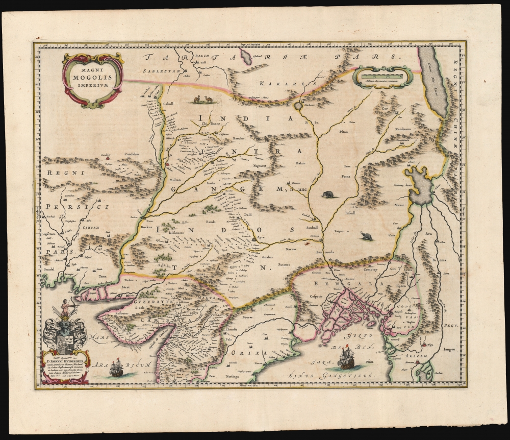
1640 Blaeu Map of Northern India, Nepal, and Pakistan
MagniMogolisImperium-blaeu-1640-2$850.00

Title
Magni Mogolis Imperium.
1640 (undated) 16.5 x 20.5 in (41.91 x 52.07 cm) 1 : 6900000
1640 (undated) 16.5 x 20.5 in (41.91 x 52.07 cm) 1 : 6900000
Description
This is an attractive, original color example of Joan and Cornelis Blaeu's 1640 map of the Mughal Empire of Northern India. It is among the most attractively engraved of the 17th-century maps derived from the unacquirable Baffin/Roe map. The map features the first accurate mapping of the Indus River and western and central India. At its heart, the map reveals the vital trade routes between the chief cities of Gujarat, Agra, and Jaisalmer and their linkage to the Silk Road center of Kabul.
A Closer Look
Centered on the Mughal capital of Agra, the map covers the Indus and Ganges River valleys, from Kabul to Orissa and Deccan, and from Persia to Bengal. Lahore, Kabul, Peshawar (Pishore) and Gujrat (Guzurat) are named, as is Kashmir (Chismere and Cassimere). While the map does not show roads, it does show the network of towns, waystations, and caravanserai built to support the bustling trade system. In particular, it reveals the administrative route linking the Imperial palaces at Agra and Lahore.The Source
This - and virtually every 17th-century map of northern India - was based on William Baffin's Indostan, the first English map of India, made based on the travels and geographical information of Sir Thomas Roe, the British East India Company's ambassador to the Mughal Empire. Roe and Baffin are thought to have worked on their map during Roe's 1619 return to England aboard the ship Anne Royal, following Roe's tenure as ambassador. Baffin, formerly an Arctic explorer, was employed as a surveyor by the East India Company and served as a Master's Mate on Anne Royal. Roe was tasked with producing a map of the Empire in India, compiling geographical data on 37 cities. Baffin added these to the map with difficulty, as he needed to reconcile Roe's data with his own charts and others that remained authoritative. Their 1619 manuscript survives in a single copy in the British Library, and the map was published that year. It also survives in only a single example at the British Library. Despite its present prohibitive rarity, the map's influence was monumental. The Dutch mapmakers Blaeu, Hondius, and Jansson copied it, and it is in their atlases that it was most broadly disseminated.Masterfully Decorative
The Dutch mapmakers of the 17th century, more often than not, copied one another's geography extensively, leading to no particular mapmaker holding the authoritative high ground. Therefore, the beauty of execution was emphasized to give the publisher a competitive edge. The neighboring rival firms of Blaeu and Hondius strove to outdo one another with fine engraving, colorwork, and ornamentation. As the work of engraving passed from Willem Blaeu to his sons Joan and Cornelis, the work of the house of Blaeu became characterized by its fine lines, balanced composition, and clarity of presentation. Mountain ranges are shown pictorially, with great finesse. Camels and two well-realized elephants grace the open spaces. Two sailing ships ply the Indian Ocean. In the upper corners, elegant shell-motif cartouches present the map's title and scales. On the lower left is a beautifully executed dedicatory cartouche to Johannes Huydekoper (1599 - 1661), a Dutch merchant who served as a director of the Dutch East India Company and was mayor of Amsterdam three times. Huydekoper was also a famous patron of the arts. He is mentioned in 1628 as the first person in Amsterdam to purchase a painting from Rembrandt. The cartouche is surmounted by the dedicatee's arms.The Lake of Chiamay
Prominent at the eastern limit of the map is the Lake of Chiamay, the apocryphal source of four important Southeast Asian river systems, including the Irrawaddy, the Dharla, the Chao Phraya, and the Brahmaputra. This lake (also called Chiam-may or Chian-may) began to appear in maps of this region as early as the 16th century and persisted well into the mid-18th century. Its origins are unknown but may originate in a lost 16th-century geography prepared by the Portuguese scholar Jao de Barros. The lake was speculated to be the source of four important Southeast Asian River systems and was mentioned in the journals of Sven Hedin. There are even records that the King of Siam led an army to seize control of the lake in the 16th century. Ultimately, the theory of Lake Chiamay was disproved, and it disappeared from maps entirely by the 1760s.Publication History and Census
This map was engraved for inclusion in the 1640 appendix to the Blaeus' 3-volume Theatrum Orbis Terrarum. This example's pagination conforms to both the French-text 1640 Appendix and Le Theatre du Monde of the same year. The map remained unchanged as part of the Blaeu's atlases for the rest of their printing history. The map is well represented in institutional collections.CartographerS
Joan (Johannes) Blaeu (September 23, 1596 - December 21, 1673) was a Dutch cartographer active in the 17th century. Joan was the son of Willem Janszoon Blaeu, founder of the Blaeu firm. Like his father Willem, Johannes was born in Alkmaar, North Holland. He studied Law, attaining a doctorate, before moving to Amsterdam to join the family mapmaking business. In 1633, Willem arranged for Johannes to take over Hessel Gerritsz's position as the official chartmaker of the Dutch East India Company, although little is known of his work for that organization, which was by contract and oath secretive. What is known is his work supplying the fabulously wealthy VOC with charts was exceedingly profitable. Where other cartographers often fell into financial ruin, the Blaeu firm thrived. It was most likely those profits that allowed the firm to publish the Theatrum Orbis Terrarum, sive, Atlas Novus, their most significant and best-known publication. When Willem Blaeu died in 1638, Johannes, along with his brother Cornelius Blaeu (1616 - 1648) took over the management of the Blaeu firm. In 1662, Joan and Cornelius produced a vastly expanded and updated work, the Atlas Maior, whose handful of editions ranged from 9 to an astonishing 12 volumes. Under the brothers' capable management, the firm continued to prosper until the 1672 Great Amsterdam Fire destroyed their offices and most of their printing plates. Johannes Blaeu, witnessing the destruction of his life's work, died in despondence the following year. He is buried in the Dutch Reformist cemetery of Westerkerk. Johannes Blaeu was survived by his son, also Johannes but commonly called Joan II, who inherited the family's VOC contract, for whom he compiled maps until 1712. More by this mapmaker...
William Baffin (c. 1584 – January 23, 1622) was an English navigator, explorer and cartographer. His efforts to discover a Northwest Passage would earn his fame, largely resulting from his discovery of the bay that bears his name. He is also known for having produced excellent surveys of the Red Sea and the Persian Gulf on behalf of the East India Company, and his collaboration on the most influential map of Northern India to be produced in the seventeenth century. Nothing is known of his early life. Samuel Purchas hailed Baffin as a 'learned-unlearned Mariner and Mathematician... wanting art of words,' conjuring a working sailor whose grasp of survey and drafting came of long experience and not education. He first appears in the historical record in 1612 as chief pilot on Captain James Hall's fourth expedition to Greenland; in the following two years he would serve as in the Muscovy Company whaling fleet around Spitzbergen. In 1615 he was hired by the Company of Merchants of London, Discoverers of the North-West Passage' and sailed as pilot under Captain Robert Bylot, who explored Hudson Strait in search of a Northwest Passage. Baffin's surveys were found to be accurate, confirmed by the explorer Parry in 1821. Returning to the Hudson Strait in 1616 he passed west of Greenland up the Davis Strait, discovering the large bay now known as Baffin's Bay and reaching the furthest point in North America explored by a European until the voyage of Inglefield in 1852. Following his efforts to find a Northwest Passage, he served the East India Company as master's mate aboard the ship Anne Royal. His travels to India between 1617 and 1619 would result in his vaunted surveys of the Red Sea and the Persian Gulf, and his superb map of the Mughal Empire produced in collaboration with Ambassador Sir Thomas Roe. In 1620, he sailed east again, taking part in a naval battle with a combined Portuguese and Dutch fleet which would see his captain killed. Baffin was shot and killed in 1622, as part of a joint effort with Persia to take Portuguese fortresses on Qeshm and Hormuz. Learn More...
Sir Thomas Roe (c. 1581 – November 6, 1644) was an English scholar, politician and diplomat, who served as England's ambassador to the Mughal Empire, the Ottoman Empire, and the Holy Roman Empire. He was born in Essex, son of Sir Robert Rowe and his wife Elinor Jermy. He entered Magdalen College, Oxford, in 1593, at the age of twelve. In 1597 he became esquire to Queen Elizabeth, and would be knighted by James I in 1604. He became friends with Henry, Prince of Wales, who in 1610 would send him on a mission to the West Indies, during which he would attempt to find El Dorado, at that time believed to be in the vicinity of the Lake Parime in South America. Between 1616 and 1619, at the behest of the East India Company, King James sent Roe to India as ambassador to the Agra court of the Mughal Emperor, Jahangir. A gracious guest, Roe arrived with a large supply of red wine, with the apparent result that he became a favourite of Jahangir and may have been his drinking partner. Roe thus successfully secured permission for the East India Company to establish a factory at Surat, giving The Company a key early foothold in India. Roe made an effort to assemble geographical data of the Mughal Empire, the interior of which was virtually unknown to Europeans. During his 1919 voyage home, he collaborated with the ship's master William Baffin in producing what would be the most influential map of that empire to be produced in the 17th century. Later, he would become ambassador to the Ottoman Empire, negotiating privileges for English merchants and in one instance making treaty with Algeria in order to free captives of the piratical kingdom. During his time in Constantinople, he was able to acquire a wealth of rare manuscripts which he would present to the King, and to the Bodleian Library. He would go on to serve as a diplomat during the Thirty Years War, arranging treaties between Sweden and Poland, Danzig and Denmark. In later years, he would sponsor arctic explorer Luke Fox, and would eventually become a privy councillor and was elected MP. Between 1641 and 1642 he would be appointed ambassador to the Holy Roman Empire, taking part in peace conferences at Hamburg, Regensburg and Vienna. Learn More...
Source
Blaeu, J. / Blaeu, C., Théâtre du Monde ou Nouvel Atlas, (Amsterdam: Blaeu) 1640.
The classic Dutch atlas, whose publication ushered in the Dutch golden age of cartography. Willem Jansz Blaeu had been, since 1604, producing engraved maps for sale; these were separate issues (and all consequently extremely rare) until the publishing of Blaeu's Appendix in 1630 and 1631, which also included a number of maps purchased from the widow of Jodocus Hondius, (for example his famous iteration of John Smith's map of Virginia.) In 1634, he announced his intention to produce a new world atlas in two volumes, entitled Theatrum Orbis Terrarum, sive Atlas Novus (Théâtre du Monde ou Nouvel Atlas) (in an effort to invoke the successful work of the same title produced by Ortelius the previous century, while reinforcing the notion of it being a new work.) This work was published first in German in 1634, followed by Latin, Dutch and French editions in 1635. Blaeu's maps have always been noted for the quality of their paper, engraving and fine coloring, and this was the intent from the very start. The 1634 announcement of the upcoming work described it: 'All editions on very fine paper, completely renewed with newly engraved copperplates and new, comprehensive descriptions.' (van der Krogt, p,43) Many of the most beautiful and desirable maps available to the modern collector were printed and bound in Blaeu's atlases. Willem's son, Joan, would go on to add further volumes to the Atlas Novus, concurrently printing new editions of the first two volumes with additional maps, in effect making these new editions an entirely new book. Under Joan there would be nine Latin editions, twelve French, at least seven Dutch, and two German. This exceedingly successful work would be the mainstay of the Blaeu firm until 1661, at which point the work was supplanted by Joan Blaeu's masterwork Atlas Maior in 1662.
Condition
Excellent. Invisibly mended wormhole with no impact to the printed image. A bold strike with original color and generous margins.
References
OCLC 1190867338. Van der Krogt, P. C. J., Koeman's Atlantes Neerlandici, Vol. 2, 8330:2. Gole,S., Early Maps of India, cf. plate 11, pp. 46.