This item has been sold, but you can get on the Waitlist to be notified if another example becomes available, or purchase a digital scan.
1641 Jansson Map of Northern India, Nepal, and Pakistan
MagniMogolisImperium-jansson-1641-2$375.00

Title
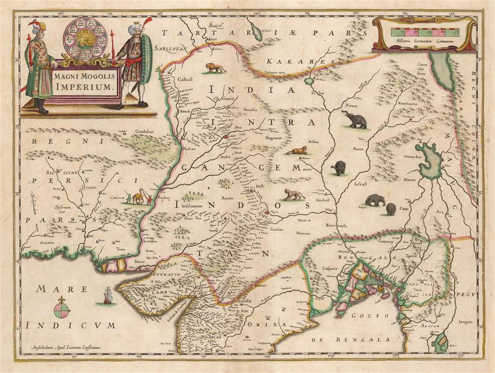
Magni Mogolis Imperium.
1641 (undated) 15 x 19.75 in (38.1 x 50.165 cm) 1 : 7800000
1641 (undated) 15 x 19.75 in (38.1 x 50.165 cm) 1 : 7800000
Description
This is an attractive, original color example of Jan Jansson's 1641 map of the Mughal Empire of Northern India. It is the most attractively engraved of the 17th century maps derived from the unacquirable Baffin / Roe map. It features the first accurate mapping of the Indus River, as well as western and central India. At its heart, the map reveals the vital trade routes between the chief cities of Gujarat, Agra, Jaisalmer, and their linkage the Silk Road center of Kabul.
A Closer Look
Centered on the Mughal capital of Agra, it covers the Indus and Ganges River valleys, from Kabul to Orissa and Deccan, and from Persia to Bengal. Lahore, Kabul, Peshawar (Pishore) and Gujrat (Guzurat) are named, as is Kashmir (Chismere and Cassimere.) While the map does not show roads, it does show the network of towns, waystations and caravanserai built to support the bustling trade system. In particular, it reveals the administrative route linking the Imperial palaces at Agra and Lahore.The Source
This - and virtually every seventeenth century map of northern India - was based on William Baffin's Indsostan, the first English map of India, made based on the travels and geographical information of Sir Thomas Roe, the British East India Company's ambassador to the Mughal Empire. Roe and Baffin are thought to have worked on their map during Roe's 1619 return to England aboard the ship Anne Royal, following Roe's tenure as ambassador. Baffin, formerly an arctic exploer, was employed as a surveyor by the East India Company and served as a Master's Mate on Anne Royal. Roe was tasked to produce a map of the Empire in India, compiling geographical data on 37 cities. Baffin added these to the map with difficulty, as he needed to reconcile Roe's data with his own charts and others that remained authoritative. Their 1619 manuscript survives in a single copy in the British Library and the map was published that year, itself surviving in only a single example at the British Library. Despite its present prohibitive rarity, the map's influence was monumental. The Dutch mapmakers Blaeu, Hondius, and Jansson copied it, and it is in their atlases that it was most broadly disseminated.Masterfully Decorative
The Dutch mapmakers of the 17th century, more often than not, copied one another's geography extensively, leading to no particular mapmaker holding the authoritative high-ground. Therefore, beauty of execution was emphasized to give the publisher a competitive edge. The neighboring rival firms of Blaeu and Hondius strove to outdo one another with fine engraving, colorwork, and ornamentation. In the case of the Baffin / Roe, Hondius and Jansson produced the the most richly decorative iteration of the work. Mountain ranges are shown pictorially, with great finesse. Lions, tigers and four well-realized elephants grace the open spaces. Two spearmen lead a camel. A galleon sails the Indian Ocean. In the upper left, a fine cartouche features a pair of Mughal nobles. Between them is the dynastic seal of the fourth Mughal Emperor, Jahangir. The seal incorporates the geneology of the Mughal dynasty.The Lake of Chiamay
Prominent at the eastern limit of the map is the Lake of Chiamay, apocryphal source of four important Southeast Asian river systems including the Irrawaddy, the Dharla, the Chao Phraya, and the Brahmaputra. This lake (also called Chiam-may or Chian-may) began to appear in maps of this region as early as the 16th century and persisted well into the mid 18th century. Its origins are unknown but may originate in a lost 16th century geography prepared by the Portuguese scholar Jao de Barros. It was speculated to be the source of five important Southeast Asian River systems and was mentioned in the journals of Sven Hedin. There are even records that the King of Siam led an army to seize of the lake in the 16th century. Ultimately, the theory of Lake Chiamay was disproved and it disappeared from maps entirely by the 1760s.Publication History and Census
This map was engraved for inclusion in the 1638 Latin edition of Henry Hondius' Atlas Novus, and its first state appeared in French editions of the atlas until the stock ran out. When Jansson inherited the firm, the map was amended with a new imprint. The present map is an example of the Jansson state, which first appeared in the 1641 German edition and remained in Hondius / Jansson atlases for the remainder of their print history. With the exception of the imprint, the plates are identical. The map is well represented in institutional collections.CartographerS
Jan Jansson or Johannes Janssonius (1588 - 1664) was born in Arnhem, Holland. He was the son of a printer and bookseller and in 1612 married into the cartographically prominent Hondius family. Following his marriage he moved to Amsterdam where he worked as a book publisher. It was not until 1616 that Jansson produced his first maps, most of which were heavily influenced by Blaeu. In the mid 1630s Jansson partnered with his brother-in-law, Henricus Hondius, to produce his important work, the eleven volume Atlas Major. About this time, Jansson's name also begins to appear on Hondius reissues of notable Mercator/Hondius atlases. Jansson's last major work was his issue of the 1646 full edition of Jansson's English Country Maps. Following Jansson's death in 1664 the company was taken over by Jansson's brother-in-law Johannes Waesberger. Waesberger adopted the name of Jansonius and published a new Atlas Contractus in two volumes with Jansson's other son-in-law Elizée Weyerstraet with the imprint 'Joannis Janssonii haeredes' in 1666. These maps also refer to the firm of Janssonius-Waesbergius. The name of Moses Pitt, an English map publisher, was added to the Janssonius-Waesbergius imprint for maps printed in England for use in Pitt's English Atlas. More by this mapmaker...
Henricus Hondius II (1597 – August 16, 1651) was a Dutch engraver, cartographer and publisher. The son of the cartographer Jodocus Hondius, Henricus took over the business after father died in 1612, co-ran the business with his brother Jodocus II. In 1628 Henricus partnered with Jan Janssonius and together they continued the business, with Jansson’s name appearing on the Atlasas co-publisher after 1633. Eventually, about 50 editions of the Atlas were released in the main European languages. In the Islamic world, the atlas was partially translated by the Turkish scholar Katip Çelebi. The series is sometimes called the 'Mercator/Hondius/Jansson' series because of Jansson's later contributions. Learn More...
William Baffin (c. 1584 – January 23, 1622) was an English navigator, explorer and cartographer. His efforts to discover a Northwest Passage would earn his fame, largely resulting from his discovery of the bay that bears his name. He is also known for having produced excellent surveys of the Red Sea and the Persian Gulf on behalf of the East India Company, and his collaboration on the most influential map of Northern India to be produced in the seventeenth century. Nothing is known of his early life. Samuel Purchas hailed Baffin as a 'learned-unlearned Mariner and Mathematician... wanting art of words,' conjuring a working sailor whose grasp of survey and drafting came of long experience and not education. He first appears in the historical record in 1612 as chief pilot on Captain James Hall's fourth expedition to Greenland; in the following two years he would serve as in the Muscovy Company whaling fleet around Spitzbergen. In 1615 he was hired by the Company of Merchants of London, Discoverers of the North-West Passage' and sailed as pilot under Captain Robert Bylot, who explored Hudson Strait in search of a Northwest Passage. Baffin's surveys were found to be accurate, confirmed by the explorer Parry in 1821. Returning to the Hudson Strait in 1616 he passed west of Greenland up the Davis Strait, discovering the large bay now known as Baffin's Bay and reaching the furthest point in North America explored by a European until the voyage of Inglefield in 1852. Following his efforts to find a Northwest Passage, he served the East India Company as master's mate aboard the ship Anne Royal. His travels to India between 1617 and 1619 would result in his vaunted surveys of the Red Sea and the Persian Gulf, and his superb map of the Mughal Empire produced in collaboration with Ambassador Sir Thomas Roe. In 1620, he sailed east again, taking part in a naval battle with a combined Portuguese and Dutch fleet which would see his captain killed. Baffin was shot and killed in 1622, as part of a joint effort with Persia to take Portuguese fortresses on Qeshm and Hormuz. Learn More...
Sir Thomas Roe (c. 1581 – November 6, 1644) was an English scholar, politician and diplomat, who served as England's ambassador to the Mughal Empire, the Ottoman Empire, and the Holy Roman Empire. He was born in Essex, son of Sir Robert Rowe and his wife Elinor Jermy. He entered Magdalen College, Oxford, in 1593, at the age of twelve. In 1597 he became esquire to Queen Elizabeth, and would be knighted by James I in 1604. He became friends with Henry, Prince of Wales, who in 1610 would send him on a mission to the West Indies, during which he would attempt to find El Dorado, at that time believed to be in the vicinity of the Lake Parime in South America. Between 1616 and 1619, at the behest of the East India Company, King James sent Roe to India as ambassador to the Agra court of the Mughal Emperor, Jahangir. A gracious guest, Roe arrived with a large supply of red wine, with the apparent result that he became a favourite of Jahangir and may have been his drinking partner. Roe thus successfully secured permission for the East India Company to establish a factory at Surat, giving The Company a key early foothold in India. Roe made an effort to assemble geographical data of the Mughal Empire, the interior of which was virtually unknown to Europeans. During his 1919 voyage home, he collaborated with the ship's master William Baffin in producing what would be the most influential map of that empire to be produced in the 17th century. Later, he would become ambassador to the Ottoman Empire, negotiating privileges for English merchants and in one instance making treaty with Algeria in order to free captives of the piratical kingdom. During his time in Constantinople, he was able to acquire a wealth of rare manuscripts which he would present to the King, and to the Bodleian Library. He would go on to serve as a diplomat during the Thirty Years War, arranging treaties between Sweden and Poland, Danzig and Denmark. In later years, he would sponsor arctic explorer Luke Fox, and would eventually become a privy councillor and was elected MP. Between 1641 and 1642 he would be appointed ambassador to the Holy Roman Empire, taking part in peace conferences at Hamburg, Regensburg and Vienna. Learn More...
Source
Jansson, J., Atlas Contractus, (Amsterdam: Jansson) 1666.
Condition
Very good. Two mends to right border, and margin extended. Six filled wormholes. Else an excellent example with rich original color.
References
OCLC 7457915. Van der Krogt, P. C. J., Koeman's Atlantes Neerlandici, Vol. I, 8300:1.2. Gole,S., Early Maps of India, cfplate 10, pp. 44-53.