This item has been sold, but you can get on the Waitlist to be notified if another example becomes available, or purchase a digital scan.
1822 Carey and Lea Map of Maine
Maine-careylea-1822$175.00

Title
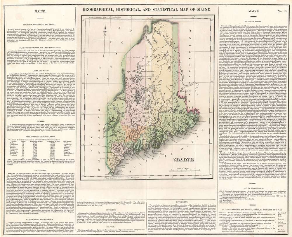
Geographical, Statistical, and Historical Map of Maine.
1822 (undated) 16.5 x 20.5 in (41.91 x 52.07 cm) 1 : 2090880
1822 (undated) 16.5 x 20.5 in (41.91 x 52.07 cm) 1 : 2090880
Description
The first printed map of the State of Maine. This is the 1822 first edition example of Henry Charles Carey and Isaac Lea's map of Maine, engraved by Joseph Yeager, (1792-1859). As is typical of the Carey and Lea atlas, the map is presented in full wash color, surrounded by explicatory text. Nine counties are shown, and are distinguished from one another both by dotted lines and color coding. In addition to the towns, rivers, lakes and other such expected details, the map marks (by means of flags, also colored distinctly) 'Places Remarkable for Battles, Sieges' et cetera, which are described and dated in the text. These are predominantly conflicts with Native American tribes, though they include one Revolutionary War battle and five incidents from the War of 1812.
The Explicative Text
The text - appearing as it does on both margins and at the bottom of the map - is richly detailed and vigorously composed. Carey's fact-rich descriptions of the state's resources are granular to the point of describing portages on the rivers, or the number of boards produced annually by the town of Machias. His 'Historical Sketch' on the right hand side of the map makes for entertaining reading as the author seems torn between defending the denizens of the then-territory for their vulnerability, yet slyly castigating them for their failure to expel British invaders.In the last war with England, a portion of the district was compelled to submit to the British arms, and remained under their control until the treaty of peace. No attempt was made to dislodge the enemy. The blame of this supineness is not to be attributed, perhaps, to the people of Maine. Being under the jurisdiction of Massachusetts, they were deprived of the means of defending themselves.The Carey and Lea atlas was popular, and it is evident that this map was consulted with some regularity for some years after its production: The 'List of Governors,' starting with Sir Ferdinand Gorges in 1635, includes five entries up to Albion K. Parris in 1821. This example has a manuscript notation bringing the map up-to-date with the 1826 governorship of Enoch Lincoln.
Publication History
This map was published by Henry Charles Carey and Isaac Lea in the 1822 edition of Carey and Lea's A Complete Historical, Chronological and Geographical Atlas. The first edition, as here, is uncommon.CartographerS
Henry Charles Carey (December 15, 1793 - October 13, 1879) was an American economist and publisher. The leading 19th-century economist of the American school of capitalism, Carey was born in Philadelphia, Pennsylvania and was the son of Mathew Carey (1760 - 1839), who was also an influential political reformer, editor, publisher, and economist. Henry Charles Carey took over the family publishing firm in 1825 after his father retired, and, partnering with his brother-in-law Isaac Lea (1792 - 1886), formed the imprint Carey and Lea. Carey retired from publishing c. 1838 and focused on his career as an economist. He was a prolific writer on the subject and published numerous works on economics between 1835 and 1876. Carey and Lea became one of the most successful publishing houses in America, publishing, among others, American editions of the works of Walter Scott and James Fenimore Cooper, The Encyclopedia Americana and a dictionary of German lexicon. More by this mapmaker...
Isaac Lea (March 4, 1792 - December 8, 1886) was an American publisher, geologist, and conchologist. Born in Wilmington, Delaware, Lea was born into a Quaker family. In an uncharacteristic move for a Quaker, Lea gave up the Quaker belief in pacifism, thus losing his claim to being a member of the Society of Friends, and joined the 7th Company of the 24th Pennsylvania Militia to fight in the War of 1812. Little is known about Lea's life after the war. He married Frances Ann Carey (1799 - 1873), the daughter of the successful publisher Mathew Carey (1760 - 1839) on March 8, 1821, with whom he had three children, one of which died in infancy. After Mathew Carey retired from publishing in 1825, Lea partnered with Carey's son Henry Charles Carey (1793 - 1879), and formed the publishing house Carey and Lea. Carey and Lea became one of the most successful publishing houses in America, publishing, among others, American editions of the works of Walter Scott and James Fenimore Cooper, The Encyclopedia Americana and a dictionary of German lexicon. After Henry Carey retired c. 1838, Lea continued publishing with William A. Blanchard, who had been promoted to partner in the Carey and Lea firm in 1833, under the imprint of Lea and Blanchard. Eventually, Lea's two sons Henry Charles Lea (September 19, 1825 - October 24, 1909) and Mathew Carey Lea (1823 - 1897) took over the publishing firm and changed its hame to Lea Brothers, after Isaac Lea decided to retire to dedicate himself to his scientific pursuits. Lea devoted his scientific study to natural history, with particular interest in freshwater and land mollusks, which he studied for fifty years. Learn More...
Source
Carey, H.C. and I. Lea, A Complete Historical, Chronological and Geographical American Atlas, (Philadelphia: Carey and Lea) 1822.
Condition
Very good. Lightly toned. Margins extended, centerfold reinforced. Blank on verso.
References
Rumsey 0122.000. OCLC 80776095.