
This item below is out of stock, but another example (left) is available. To view the available item, click "Details."
Details
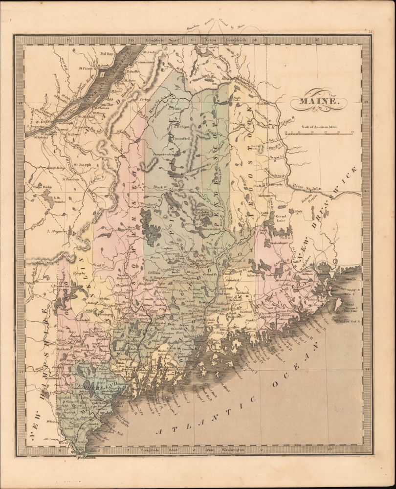
1842 Greenleaf Map of Maine
1842 (undated) $300.00
1849 Greenleaf Map of Maine
Maine-greenleaf-1849$150.00

Title
Maine.
1849 (undated) 11.5 x 14 in (29.21 x 35.56 cm) 1 : 1650000
1849 (undated) 11.5 x 14 in (29.21 x 35.56 cm) 1 : 1650000
Description
This is Jeremiah Greenleaf's 1849 map of Maine.
A Closer Look
The map covers the state of Maine as well as adjacent parts of New Hampshire and Canada, including Quebec City. At this point, railroads penetrated Maine no further than Portland, underscoring the extent to which the state relied on its extensive river networks and road for transport. The map includes a ghosted northern boundary demarcation that breaks the map's border - an element inherited from the 1835 Burr source map, which, when it was engraved was an ongoing political conflict.Historical Context
In 1841, Maine, which had achieved statehood just two decades prior in 1820 as part of the Missouri Compromise, was rapidly developing its own identity. Its vast pine forests were the backbone of a thriving lumber industry, which in turn stimulated shipbuilding in towns like Bath and Bangor. The expansive coastline supported a robust fishing sector, making Maine a pivotal hub for maritime activities. Additionally, the state's picturesque landscapes of mountains, lakes, and coastlines began attracting artists and early tourists, hinting at the role Maine would soon play as a revered destination for nature enthusiasts and those seeking its tranquil beauty.Northern Border Dispute
Of great interest, the map includes a ghosted northern boundary demarcation that breaks the map's border. The dispute over Maine's northern border was part of the larger Aroostook War (1838 - 1839), a non-violent confrontation between the United States and the United Kingdom during the 1830s and early 1840s. The disagreement stemmed from ambiguities in the Treaty of Paris (1783) and the Treaty of Ghent (1814) regarding the delineation of the boundary between British North America (later Canada) and the state of Maine. The contested region, rich in timber and known as the Aroostook Valley, became a flashpoint with both American and British settlers and lumberjacks moving into the area. Tensions escalated with both sides sending troops, but the conflict never resulted in direct military clashes. The border dispute was eventually settled by the Webster-Ashburton Treaty of 1842, which delineated the modern boundaries of Maine and what is now the Canadian province of New Brunswick.Publication History and Census
This map is a much-revised Greenleaf issue of the David Hugh Burr / 'Illman and Pilbrow' map of 1835. The Burr map plates fell into the hands of Jeremiah Greenleaf, who revised them for publication in his own Universal Atlas. The present example is from the 1849 edition of the atlas, the last and final, which was extensively revised over the 1848. We note an example in the David Rumsey Map Collection, which has been populated digitally throughout OCLC, making a comprehensive survey of existing physical examples nearly impossible. Nonetheless, the 1849 edition of the atlas is rare, which Rumsey correctly notes is not in Karpinski. We do note an example, however, in Phillips.CartographerS
Jeremiah Greenleaf (1791 - 1864) is a little known but highly admired American cartographer of the early 19th century. He published from roughly 1830 to 1850. His most important work is A New Universal Atlas; Comprising of all the Principal Empires, Kingdoms, and States Throughout the World and Forming a distinct Atlas of the United States, published in several editions in the 1840s. Many of his maps are reformatted versions of his contemporary David Burr's much admired cartographic works. Greenleaf's maps are extremely rare and admired for their stunningly vivid pastel color washes. More by this mapmaker...
David Hugh Burr (August 18, 1803 - December 25, 1875) of one of the first and most important truly American cartographers and map publishers. Burr was born in Bridgeport Connecticut in August of 1803. In 1822 Burr moved to Kingsboro, New York to study law. A year and a half later he was admitted to the New York Bar association. Burr must have questioned his choice of careers because shortly after being admitted to the Bar, he joined the New York State Militia. Though largely untrained in the art of surveying, Burr was assigned to work under Surveyor General of New York, Simeon De Witt, to survey several New York Roadways. Seeing a window of opportunity, Burr was able to negotiate with the governor of New York at the time, De Witt Clinton, to obtain copies of other New York survey work in order to compile a map and Atlas of the state of New York. Recognizing the need for quality survey work of its territory, the government of New York heartily endorsed and financed Burr's efforts. The resulting 1829 Atlas of the State of New York was the second atlas of an individual U.S. state and one of the most important state atlases ever produced. Burr went on to issue other maps both of New York and of the United States in general. In cooperation with publishing firm of Illman & Pillbrow, he produced an important New Universal Atlas and, with J.H. Colton, several very important maps of New York City. In recognition of this work, Burr was appointed both "Topographer to the Post office" and "Geographer to the House of Representatives of the United States". Later, in 1855, Burr was assigned to the newly created position of Surveyor General to the State of Utah. Burr retired from the position and from cartographic work in general in 1857 when light of some of his financial misdeeds and frauds came to light. He was accused of submitting false expense reports and underpaying employees, among other indiscretions. Learn More...
Source
Greenleaf, J., New Universal Atlas, (Brattleboro, Vermont: Greenleaf) 1849.
Condition
Very good. Even overall toning.
References
Rumsey 15176.038.