
This item below is out of stock, but another example (left) is available. To view the available item, click "Details."
Details
1858 Walling Wall Map of Piscataquis County, Maine
1858 (dated) $2,500.00
1969 Shelley and Koster Pictorial Wall Map of Maine
Maine-shelleykoster-1969$475.00


Title
Maine.
1969 undated 41.75 x 32.25 in (106.045 x 81.915 cm)
1969 undated 41.75 x 32.25 in (106.045 x 81.915 cm)
Description
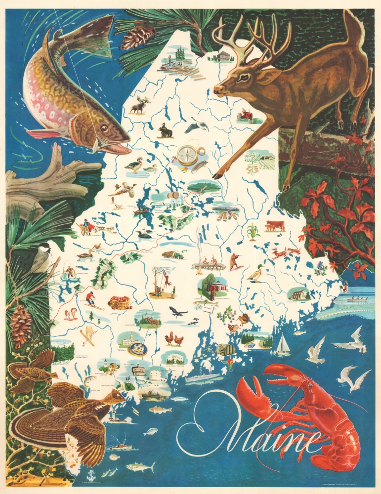
This is a 1969 J.G. Shelley and Louis Koster pictorial wall map of Maine. Shelley and Koster's work celebrates Maine's iconic wildlife and the many outdoor activities one can enjoy while in Maine.
A Closer Look
Pictorial vignettes and illustrations fill the state. Ducks, deer, pheasants, loons, woodcocks, fish, and moose appear alongside fishermen, hunters, and skiers. Vignettes highlight the University of Maine, Colby College, Bowdoin College, and the state house in Augusta. Acadia National Park, White Mountain National Forest, and Mt. Katahdin also merit vignettes. Maine's logging industry is also celebrated. A pictorial border features large illustrations of a deer, a fish, a chickadee, and two grouse.Publication History and Census
This map was created by J.G. Shelley and Louis Koster and published by the Simonds, Payson Company in January 1969. Although this piece is undated, we found a digitized Library of Congress Catalog of Copyright Entries that states this piece was copyrighted in January 1969. This piece is not cataloged in OCLC. Reproductions appear on the market, but we know only one other original in private hands.Condition
Very good. Some toning to lower quarter.