This item has been sold, but you can get on the Waitlist to be notified if another example becomes available, or purchase a digital scan.
1827 Vandermaelen map of the Straits of Malacca and Singapore
Malacca-vandermaelen-1827-2$425.00

Title
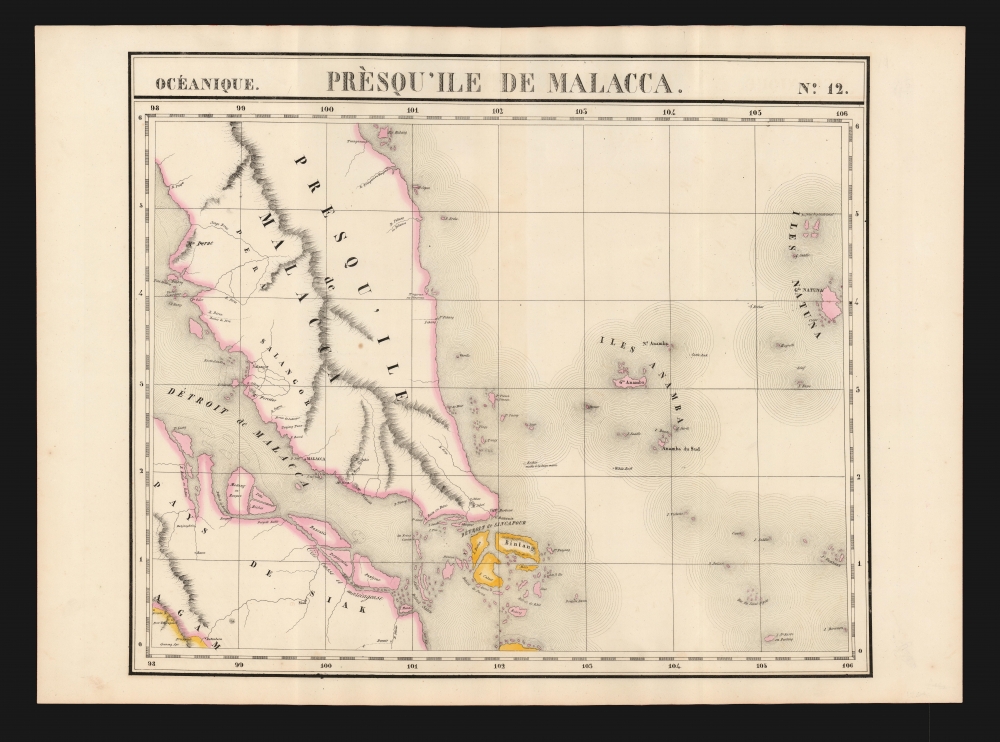
Presqu'ile de Malacca. Oceanique no. 12.
1827 (undated) 18.75 x 22.5 in (47.625 x 57.15 cm) 1 : 1641836
1827 (undated) 18.75 x 22.5 in (47.625 x 57.15 cm) 1 : 1641836
Description
This is the 1827 Vandermaelen map of Singapore and the Malay Peninsula. It is the first large-scale atlas map to focus on the area, and the first to be executed in lithography. The map shows Singapore Island, Bintan, Kepulauan Anambas, Kepulauan Natuna Besar, and part of Sumatra. The interior details of Malacca - particularly the attractively hachured mountains appearing on the Malay Peninsula - reveal that despite the presence for nearly eight years of an English colony on Singapore, European knowledge of this part of the world remained scant. In all fairness, this ignorance cannot be laid entirely at Vandermaelen's feet: the Jackson plan itself would not be published for still another year, in 1828, and it was the first map to show the colony.
Publication History and Census
This map appeared in the sixth part, 'Océanique,' of Vandermaelen's Atlas universel de géographie physique, politique, statistique et minéralogique. The atlas was produced in one edition in 1827; only 810 complete sets were sold. The full set of six volumes appears in eleven institutional collections in OCLC; the 6th volume alone is listed in 10. This map is listed separately only in the collection of the National Library Board of Singapore.Cartographer
Philippe Marie Guillaume Vandermaelen (December 23, 1795 - May 29, 1869) was a Flemish cartographer active in Brussels during the first part of the 19th century. Vandermaelen is created with "one of the most remarkable developments of private enterprise in cartography," namely his remarkable six volume Atlas Universel de Geographie. Vandermaelen was born in Brussels in 1795 and trained as a globe maker. It was no doubt his training as a globe maker that led him see the need for an atlas rendered on a universal scale in order that all bodies could be understood in relation to one another. In addition to his great work Vandermaelen also produced a number of globes, lesser maps, a highly detailed 250 sheet map of Belgium, and several regional atlases. More by this mapmaker...
Source
Vandermaelen, P., Atlas universel de geographie physique, politique, statistique et mineralogique, (Bruxelles: Vandermaelen) 1827.
Atlas Universel de Geographie. This great work, featuring some 378 unique maps and compiled over three years, was the first lithograph atlas, and the first to render the world on the same projection and at a uniform scale. It was no doubt Vandermaelen’s training a globe maker that led him see the need for an atlas rendered uniformly so that all bodies could be understood in relation to one another. As a result, many newly emerging areas received more attention than prior efforts. Maps of the American West, in particular, benefited: ‘no mapmaker had previously attempted to use such a large scale for any western American area.’ (Wheat). Central and South Asia also appear in sharper focus. Despite Vandermaelen’s reliance upon existing sources, his maps very frequently provided the clearest depictions available of many poorly-understood parts of the world. The atlas was an expensive production, costing $800 in 1827. Subscription lists indicate that only 810 full sets of the atlas were sold. It was printed on high-quality paper with superior hand coloring and was engraved in a clear, legible style. Conjoined, the maps of Vendermaelen's atlas would create a massive globe some 7.75 meters in diameter, a feat which was accomplished at the Etablissement Geographique de Brussels.
Condition
Fine, with original wash color and generous margins.
References
Durand, F. and Curtis, D. R., Maps of Malaya and Borneo 115. Rumsey 2212.340. OCLC 308613639.