This item has been sold, but you can get on the Waitlist to be notified if another example becomes available, or purchase a digital scan.
1889 British Admiralty Map of the Malacca Strait and Penang, Malaysia
MalaccaStraitPenang-admiralty-1889$750.00

Title
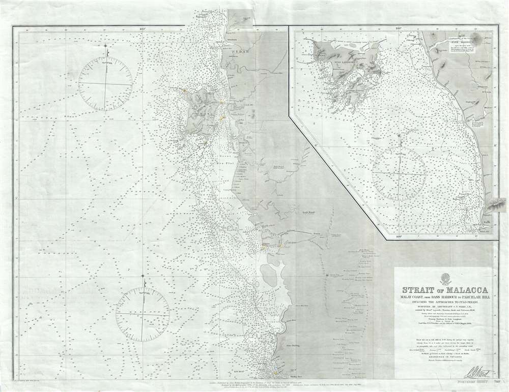
Strait of Malacca Malay Coast, from Bass Harbour to Parcelar Hill Including the Approaches to Pulo Penang.
1889 (dated) 25.5 x 32.5 in (64.77 x 82.55 cm) 1 : 300000
1889 (dated) 25.5 x 32.5 in (64.77 x 82.55 cm) 1 : 300000
Description
A rare 1889 British Admiralty nautical chart or maritime map of the northern part of the Strait of Malacca, including the island of Penang (Georgetown). The map covers the western shore of the Malay Peninsula from Kedah to the mouth of the Dinding River, in modern day Perak. An inset on the upper right continues along the coast northward to include the Andaman Sea archipelago of Langkawi, known as the Jewel of Kedah. Pulo Penang, Malaysia's modern cay culinary capital, features prominently in the northern quadrants of the map. There is minimal inland detail in general, but he course of the Perak river is detailed as far north as Kuala Kangsar, Perak's royal town.
Today this chart is quite rare with the OCLC isolating no other examples. We have identified a single example at the National Maritime Museum in Greenwich, London.
Publication History
This map as firs published by John Walker, geographer to the Secretary of State for India on April, 15 of 1859. It was significantly revised and reissued by the Hydrographic Office of the Admiralty with corrections in October of 1874. Subsequent corrections followed in 1875, 1877, 1881, 1884, 1886, and, as here, 1889. Later editions also followed. All examples are based upon initial surveys conducted in 1858 by British Royal Navy Lieutenant C/ Y. Ward, and his assistants Laycock, Pearson, Jacob, and Cochrane. Updates from 1884 follow on the work of Commander F. C. Vereker on board the H.M.S. Magpie.Today this chart is quite rare with the OCLC isolating no other examples. We have identified a single example at the National Maritime Museum in Greenwich, London.
Cartographer
The British Admiralty Office (1795 - Present) or the United Kingdom Hydrographic Office refers to the Branch of the English government that is responsible for the command of the British Navy. In 1795 King George III created the United Kingdom Hydrographic Office, known in short as the U.K.H.O., to provide top notch nautical charts to the vast Royal Navy. Prior the founding of the Admiralty the surveying and creation of nautical charts was primarily a commercial venture wherein the cartographer himself, more of than not, actually financed the printing of his own material. The great navigator Cook himself is known to have scrambled for funds to publish his own seminal charts - the most important and advanced of the period. The system of privately funded nautical mapping and publishing left vast portions of the world uncharted and many excellent charts unpublished. King George III, responding significant loss in trade revenue related to shipwrecks and delay due to poor charts, recognized the need for an institutionalized government sponsored cartographic agency - the Admiralty. The first head of the Admiralty, a position known as Hydrographer, was the important cartographer Alexander Dalrymple. Dalrymple started by organizing and cataloging obtainable charts before initiating the laborious process of updating them and filling in the blanks. The first official Admiralty Chart appeared in 1800 and detailed Quiberon Bay in Brittany. By 1808 the position of Hydrographer fell to Captain Thomas Hurd. Hurd advocated the sale of Admiralty charts to the general public and, by the time he retired in 1829, had issued and published some 736 charts. Stewardship of the organization then passed to Rear Admiral Sir Francis Beaufort. It was under Beaufort's administration that the Admiralty truly developed as a "chart making" as opposed to a "chart cataloging" institution. Beaufort held his post from 1829 to 1854. In his 25 years at the Admiralty Beaufort created nearly 1500 new charts and sponsored countless surveying and scientific expeditions - including the 1831 to 1836 voyage of the H.M.S. Beagle. By 1855 the Admiralty's chart catalog listed some 1,981 charts. More by this mapmaker...
Condition
Very good. Original linen backing. Slight centerfold wear.
References
National Maritime Museum, G257:1/18A.