1888 Dépôt de la Marine Map or Chart of the Malay Peninsula and Singapore
MalaiseSingapoure-marine-1888$950.00

Title
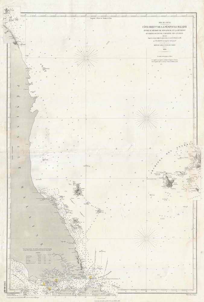
Côte Orientale de la Péninsule Malaise entre le Détroit de Singapoure de la Grande Redan et Partie Occidentale de l'Archipel des Anambas.
1888 (dated) 37 x 25 in (93.98 x 63.5 cm) 1 : 528000
1888 (dated) 37 x 25 in (93.98 x 63.5 cm) 1 : 528000
Description
This is an 1888 Dépot des Cartes et Plans de la Marine nautical map of the Malay Peninsula and Singapore. The map reflects growing French influence in and around Singapore, a major trading partner for French Indochina.
A Closer Look
Coverage embraces the southern Malay Peninsula and surrounding seas from Pulau Redang (Redang Island) to Pulau Batam and Pulau Bintan and from the Malay Peninsula to the Anambas Archipelago. Based on a British Admiralty chart, the current example has been modified to include observations made by French officers.The French in Singapore
In the late 1800s, the French community in Singapore grew as France expanded its colonial influence in Southeast Asia, particularly with its establishment of French Indochina (modern-day Vietnam, Laos, and Cambodia). Singapore, a British colony, became an essential trading and diplomatic outpost for the French in the region. French merchants, diplomats, and missionaries used Singapore as a hub to engage with the larger Southeast Asian market and as a point of access to the region’s resources and goods. The French also contributed to Singapore’s cultural landscape by establishing schools, religious institutions, and businesses, creating a small yet influential community that mingled with the diverse populations of the island.A Closer Look
oThis map was published by the Dépôt des Cartes et Plans de la Marine in 1888.CartographerS
Dépôt des Cartes et Plans de la Marine (fl. 1720 - present), often called the Dépôt de Marine, was a French hydrographic mapping organization founded in 1720 under Charles-Hercule of Albert de Luynes (1674 - 1734). Much like the U.S. Coast Survey, the British Admiralty, and the Spanish Deposito Hydrografico, the Dépôt was initiated as a storehouse and distribution center of existing nautical and marine charts. Eventually the Dépôt initiated its own mapping activities in an attempt to improve and expand upon existing material. Some of the more prominent cartographers and hydrographers associated with the of Dépôt des Cartes were, Philippe Buache, Jacques-Nicholas Bellin, Giovanni Rizzi-Zannoni, Rigobert Bonne, and Jean Nicolas Buache. More by this mapmaker...
The British Admiralty Office (1795 - Present) or the United Kingdom Hydrographic Office refers to the Branch of the English government that is responsible for the command of the British Navy. In 1795 King George III created the United Kingdom Hydrographic Office, known in short as the U.K.H.O., to provide top notch nautical charts to the vast Royal Navy. Prior the founding of the Admiralty the surveying and creation of nautical charts was primarily a commercial venture wherein the cartographer himself, more of than not, actually financed the printing of his own material. The great navigator Cook himself is known to have scrambled for funds to publish his own seminal charts - the most important and advanced of the period. The system of privately funded nautical mapping and publishing left vast portions of the world uncharted and many excellent charts unpublished. King George III, responding significant loss in trade revenue related to shipwrecks and delay due to poor charts, recognized the need for an institutionalized government sponsored cartographic agency - the Admiralty. The first head of the Admiralty, a position known as Hydrographer, was the important cartographer Alexander Dalrymple. Dalrymple started by organizing and cataloging obtainable charts before initiating the laborious process of updating them and filling in the blanks. The first official Admiralty Chart appeared in 1800 and detailed Quiberon Bay in Brittany. By 1808 the position of Hydrographer fell to Captain Thomas Hurd. Hurd advocated the sale of Admiralty charts to the general public and, by the time he retired in 1829, had issued and published some 736 charts. Stewardship of the organization then passed to Rear Admiral Sir Francis Beaufort. It was under Beaufort's administration that the Admiralty truly developed as a "chart making" as opposed to a "chart cataloging" institution. Beaufort held his post from 1829 to 1854. In his 25 years at the Admiralty Beaufort created nearly 1500 new charts and sponsored countless surveying and scientific expeditions - including the 1831 to 1836 voyage of the H.M.S. Beagle. By 1855 the Admiralty's chart catalog listed some 1,981 charts. Learn More...
Condition
Good. Light water damage around border. Verso reinforcement to centerfold. Closed margin tears professionally repaired on verso.