This item has been sold, but you can get on the Waitlist to be notified if another example becomes available, or purchase a digital scan.
1903 Stanford Map of the Malay Peninsula (Malaysia, Singapore)
MalayPeninsula-stanford-1903$600.00

Title
A Map of the Malay Peninsula.
1903 (dated) 25 x 21 in (63.5 x 53.34 cm) 1 : 1000000
1903 (dated) 25 x 21 in (63.5 x 53.34 cm) 1 : 1000000
Description
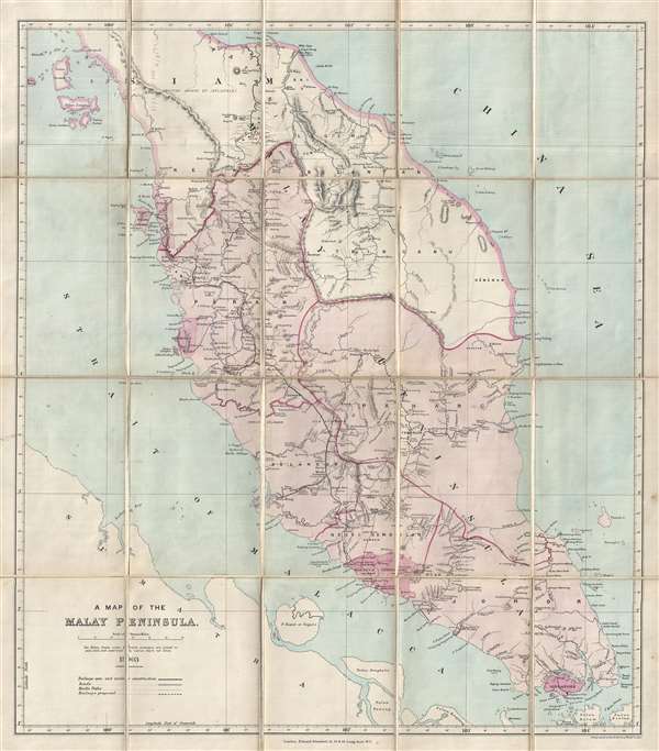
This is a 1903 scarce map of the Malay Peninsula by Edward Stanford, including all of modern day Malaysia, Singapore, and parts of Thailand. The map extends form Ko Tarutao and Langkawi, south as far as Singapore and Sumatra, and from the Strait of Malacca to the South China Sea. The map identifies roads, rail lines, rubber plantations, riverways, geographical features, indigenous villages, and more. An area at the right of the map is outlined in manuscript yellow.
The map focuses on British sovereignty in the region, with areas of direct British Administration, including Pengang, Wellesley, Dindings, Malacca, and Sinapore appear in red. The Federated Malay States, including Selangor, Perak Negeri Sembilan, and Pahang, appear in Pink, denoting nominal British control. Surrounding areas to the north, administered by the Kingdom of Siam, are considered under the British 'Sphere of Influence.' Siamese power at the time extended well south of the current Thailand-Malaysia border to include Tringanu (Terengganu).
The 'Boundary claimed for Rahman' appears just east of Pulu Pinang (Penang) along the Tongkal Range. The Kingdom of Reman or Kingdom of Rahman was a landlocked traditional Malay kingdom established in the northern Malay Peninsula. It became one of the seven states of Persekutuan Pattani Besar (The Great Pattani Federation) between 1810 and 1902 and is thus reflected here.
The map illustrates the growing and sophisticated rail network the British were actively constructing throughout the Federated Malay States (F.M.S.). At the time of printing, the railway was actively from Butterworth (Wellesley), south to Ipoh, Telok Anson, Kuala Lumpur, and Port Dickson, just north of Malacca. Kuala Lumpuer, here identified aws Kwala Lumpur, is also named 'The Residency.' The 'Residency' referred to a colonial administrative system whereby the Sultan was assigned a 'Resident' advisor, at the time of publication William Hood Treacher, who served as the de facto ruler. At the time of issue, the Malay peninsula was one of England's most profitable colonies, supplying nearly 55% of the world's supply of Tin.
This map was issued in 1903 by Edward Stanford's Geographical Establishment from their offices as 12, 13, and 14 Long Acre, London. Cartographically it is most likely derived from early F.M.S. Surveys, but predates the official publications. This map was issued in 1913 by Edward Stanford's Geographical Establishment from their offices as 12, 13, and 14 Long Acre, London.
Cartographer
Edward Stanford (May 27, 1827 - November 3, 1904) was one of the most prolific map publishing firms of the late 19th century. The company began as a partnership in 1848 between the 21 year old Edward Stanford and the established map dealer Trelawney Saunders. By 1853 the partnership had dissolved and Edward Stanford took full control of the business. A subsequent series of expansions and exciting new map issues finally led to the production of Stanford's masterwork, "Stanford's Library Map of London". This map is still available and remains somewhat accurate. At the time of publishing it was hailed by the Royal Geographical Society as "the most perfect map of London that has ever been issued". In 1882 Edward Stanford Sr. passed the firm on to his son, Edward Stanford Jr. who continued in his father's proud tradition. Today the Stanford firm still publishes maps and remains one of the most important and prolific cartographic publishers in the world. More by this mapmaker...
Condition
Very good. Folds into origal binder. Dissected and mounted on original linen.
References
OCLC 776645553.