This item has been sold, but you can get on the Waitlist to be notified if another example becomes available, or purchase a digital scan.
1786 Tofino Nautical Chart or map of Mallorca, Spain
Mallorca2-tofino-1786$1,100.00

Title
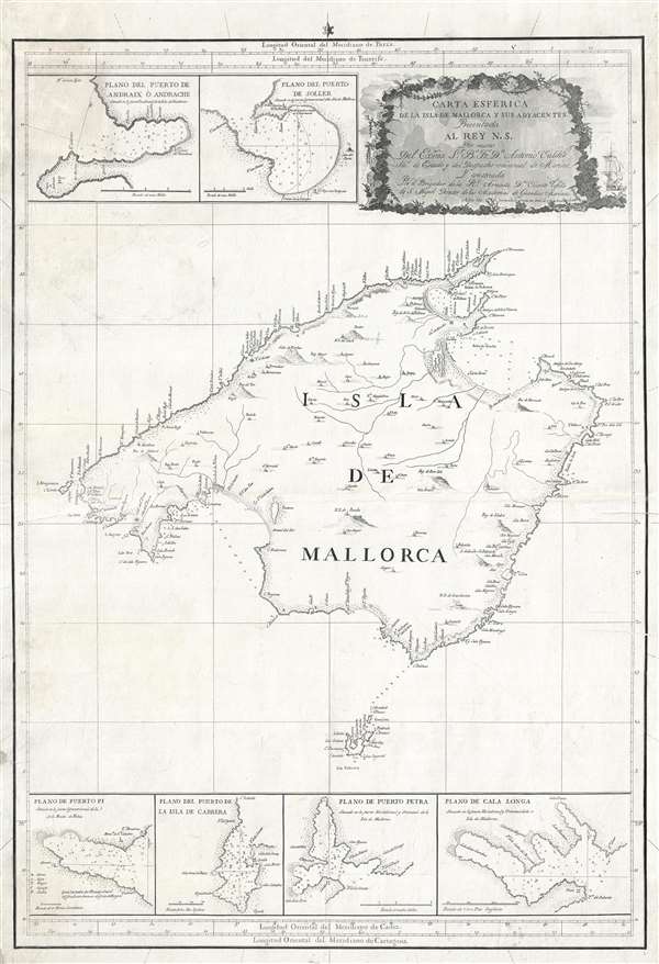
Carta Esferica de la Isla de Mallorca y sus adyacentes. Presentada al Rey N. S. por mano de... Antonio Valdés y construida por... Dn. Vicente Tofiño de S. Miguel, año 1786.
1786 (dated) 35 x 24 in (88.9 x 60.96 cm) 1 : 1210000
1786 (dated) 35 x 24 in (88.9 x 60.96 cm) 1 : 1210000
Description
An extremely rare large scale 1786 Spanish nautical chart detailing the Balearic Island of Mallorca (Majorca) by the famed hydrographers Vincente Tofiño de San Miguel and Antonio Valdés y Fernández Bazán. The map covers Mallorca in full inclusive of the adjacent island of Cabrera. Depth soundings are evident near major ports. Inset detail maps include Puerto de Andraix o Andrache, Puerto de Soller, Puerto Pi, Puerto de La Isla de Cabrera, Puerto Petra, and Cala Longa. The whole is beautifully engraved with villages represented by tiny finely etched illustrations of churches. A decorative title cartouche appears in the upper right quadrant.
Mallorca is known for its beach resorts and sheltered coves, limestone mountains, and Roman and Moorish remains. The capital, Palma, is admired for its 13th-century Santa María cathedral and hosts the annual Copa del Rey regatta. Stone-built villages include Pollença, with its art galleries and summer classical music festival, and the hillside Fornalutx, surrounded by terraced citrus plantations.
At the command of Valdés, Tofiño surveyed the Balearic Islands between 1783 and 1788. The results of their work appear to have been issued first independently then bound into various composite nautical atlases from about 1788.
CartographerS
Vincente Tofiño de San Miguel (September 6, 1732 - 1795) was a Spanish naval officer and hydrographer active in the second half of the 18th century. Tofiño was born in Cadiz, Spain. His father, a career army officer, died in the 1746 Battle of Placentia, leaving Vincente an orphan from age 14. He moved to Extremadura where his uncle, a priest, raised him. In 1750, following in his father's footsteps, he joined the army. Having discovered a proficiency in mathematics, Tofiño was assigned to an artillery unit. In 1755, moving from the army to the navy, where his skills were better suited, he became a professor of mathematics at the Academia de Guardia Marinas de Cádiz. He would remain in the navy for the subsequent 30 years, ultimately attaining the rank of Rear Admiral. Between 1783 and 1788, as a navy officer, astronomer, and hydrographer, he was deployed to survey the Mediterranean ports of Spain, the Balearic Islands, and the Barbary Coast. He trained the explorers Dionisio Alcalá Galiano and Cayetano Valdés y Flores Bazán, who named Tofino Inlet, in Vancouver, after him. Tofiño was elected correspondent of the Spanish Academy of History and of the French and Portuguese Academies of Science. He died in Cadiz in 1795. More by this mapmaker...
Antonio Valdés y Fernández Bazán (1744 – April 4, 1816) was a Spanish naval officer active in the latter part of the 18th century. He was born In Burgos, Spain, and entered the navy at age 13. He distinguished himself in the defense of Morro Castle and San Salvador de la Punta Fortress during the Battle of Havana (1762). He also fought against the Barbary Coast pirates in 1767. In 1781, he became director of the Royal Artillery Factory of La Cavada, and reorganized it to that extent that he was promoted to become inspector general of the Spanish Navy. In 1783, at the age of 38, he became Navy Minister and continued the modernization of the Spanish Navy. He became a knight in the Order of the Golden Fleece in 1797. His nephew, the explorer Cayetano Valdés y Flores, named Valdez, Alaska and Valdez, Florida, after him. Learn More...
Condition
Very good. Minor edge wear and verso reinforcement. Slight soiling in the upper left quadrant.
References
Instuit Cartografic i Geologic de Catalunya, RM.248327.