1890 Bacon Map or Plan of Manchester, England
Manchester-bacon-1890$250.00

Title
Plan of Manchester.
1890 (undated) 21 x 29 in (53.34 x 73.66 cm) 1 : 88000
1890 (undated) 21 x 29 in (53.34 x 73.66 cm) 1 : 88000
Description
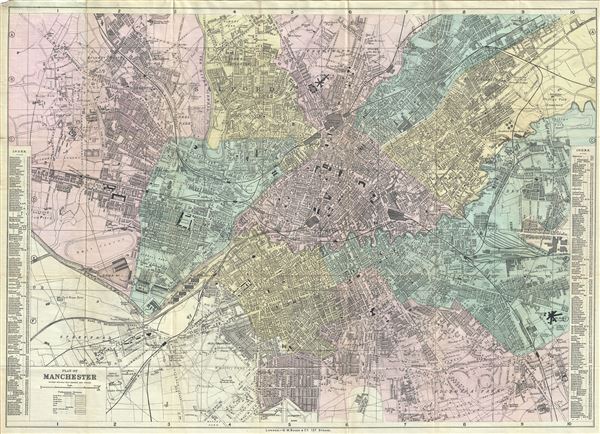
This is a beautiful c.1890 map or plan of Manchester, England by G. W. Bacon. It covers the city of Manchester and depicts individual streets, buildings, parks, canals, docks, railways, stations, and a host of additional topographic features. Notes the Throstle Nest Farm, where Manchester United would build their football ground Old Trafford, in 1909. The Manchester Ship Canal, the world's first planned industrial estate and the largest in England, is noted. A street index near the left and right margins is included. In 1830, Liverpool and Manchester became the first cities to have an intercity rail link, through the Liverpool and Manchester Railway. This map was issued in c.1890 by G. W. Bacon and Company, London.
Cartographer
George Washington Bacon (1830 - 1922) was a London based book and map publisher active in the mid to late 19th century. Bacon's firm G.W. Bacon and Co. purchased the plates created by Edward Weller for the Weekly Dispatch Atlas then modified and updated them for several of their own important atlases, including The New Ordnance Atlas of the British Isles. In 1893, Bacon & Co. acquired the map publishing business of J. Wyld. Then, around the turn of the century, Bacon & Co. itself was folded into the Scottish publishing house of W.& A.K. Johnston. More by this mapmaker...
Condition
Very good. Minor wear and toning along fold lines. Backed on linen.