
1900 Ren Manuscript Fan Map of Manchuria and Environs, Border Defenses

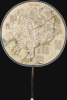
東三省俄部邊防全省圖說 / [Illustrated Description of the Russian Section of the Three Eastern Provinces for Border Defense].
Imperial Struggle for the Manchu Homeland
$11,000.00
Choose a Collection:
- Digital Map Information
- Suitable for large format printing
- Full resolution TIFF file
- ICC color profile embedded
- Delivered instantly via download link
This Item
Enquire
Imperial Struggle for the Manchu Homeland
This is a stunning c. 1900 manuscript fan map of Manchuria prepared by a group of Qing military officers led by one surnamed Ren. Demonstrating astonishingly fine and meticulous workmanship, it covers the border region of Manchuria at a time when Qing rule of their Manchu homeland was greatly imperiled by both the Russian Empire and Imperial Japan.A Closer Look
Measuring 15.75 x 10.75 in. including the handle, with the map portion measuring 10.5 x 10.75 in., this manuscript fan map covers the 'Three Eastern Provinces' (東三省) of Manchuria (Liaoning, Jilin, and Heilongjiang), which included the homeland of the Manchus, the rulers of the massive Qing Dynasty. It also includes the Korean Peninsula and as far north as the Outer Khingan Range (外興安嶺), known in Russian and English as the Stanovoy Range (Станово́й хребе́т, literally meaning 'backbone,' from the Evenki name and legend of the mountains as the backbone of the Earth). From the 1689 Treaty of Nerchinsk until the 1858 Treaty of Aigun, the border between the Qing Dynasty and the Russian Empire stretched to this mountain range, taking in today's Vladivostok, Khabarovsk, and much else besides. This area has since been called Outer Manchuria or Russian Manchuria within the larger Russian Far East. At far bottom-left is the historical seaside gate in the Great Wall of China at Shanhaiguan (山海關), the point at which Qing troops first entered China proper in 1644, indicating that the area depicted here is all beyond the scope of the Great Wall.Thanks to the small size of the text, a tremendous amount of detail is provided on both sides of the border, but particularly on the Russian side of the post-1858 border. Russian cities and administrative divisions are named, with extensive descriptions on the area, geography (mountains, rivers, terrain), and economic activity therein. The exact administrative divisions are unclear as Chinese terms (especially province 省) are used instead of Russian (such as oblast, krai, and uezd). Often, earlier Chinese toponyms (themselves based on Manchu words) are used as the primary name instead of the newer Russian toponyms, though the Russian names are usually also mentioned in the description (many being lost or garbled in translation). For example, near the outlet of the Amur River the city known in Russian as Nikolayevsk-on-Amur (Никола́евск-на-Аму́ре) is referred to as Miao'er (廟爾), based on the Manchu name 'miyoo gašan' (transliterated into Chinese as 廟街). It is noted here as the administrative center of a 'province' (廟爾距伯利省), whose Russian name of Nikolayevsk is somewhat garbled as Ligelaisike (利格來斯克).
Red lines trace both the border between Russia and China as well as the routes of railways and telegraph lines (電線), including the Trans-Siberian Railway. The word 'Russia' 俄羅斯 is also written in large red characters. A railway is shown running from Uiju (義, now Sinuiju) in Korea across the Yalu River through Andong (安東, now Dandong). It is unclear if there is meant to be a bridge; the earliest bridge over the Yalu was built by the Japanese between 1909 and 1911 (the 'Great Yalu River Bridge' 鴨綠江大橋, destroyed during the Korean War and now known as 'the Broken Bridge'). At right and bottom-right are large blocks of text about Vladivostok (海參崴), Russian naval capabilities, and the overall strategic importance of the border. In addition to settlements and mountains, waterways are labelled throughout, including the Heilongjiang ('Black Dragon River'), that is, the Amur River, recorded here with the ancient name Huntongjiang (混同江). Its main tributary, the Songhua River (松花江), is also clearly marked with its own tributaries, as is Lake Khanka (興凱湖), the Yalu River (鴨綠江), the Tumen River (大圖們江), and the Sea of Okhotsk (俄阿林特士克海) and nearby Sakhalin Island (庫葉島).
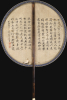
The verso contains text that is of a quite different nature than the recto content, though an educated contemporary reader would likely have been able to sense the author's intended connection. It is a selection from a highly esoteric Daoist work known as the 'Classic of the Flying Spirit' (靈飛經) that became famous in the Tang Dynasty as a demonstration of small-script calligraphy. The text itself speaks of luminous beings and their affiliated troops, wielding divine talismans and magical weapons to fight off evil spirits and bring universal peace. The choice of this text might simply have been a laudatory reference to the finely detailed small-character calligraphy on the map, but it also likely was intended as a subtle message about warding off foreign threats. In any event, the author of the verso text is different from the makers of the map, as it is signed Zhao (趙, whose given name is difficult to decipher but may be 幸). The text is 'respectfully presented' to a recipient named Shaoming (少銘), almost certainly the fan's original owner.
Historical Context
The Sino-Russian border in Manchuria took its modern shape in the mid-19th century, during a period when Qing authority was strained by internal rebellion and foreign pressure. Prior to this period, the Qing and Romanov empires had defined a loose frontier through the Treaties of Nerchinsk (1689) and Kyakhta (1727), which aimed to stabilize relations in the Amur region. For more than a century, these agreements held, in part because both empires were preoccupied elsewhere. But by the 1840s - 50s, the balance of power shifted dramatically, as Russia sought secure access to the Pacific and to the Amur River as a transportation artery, while the Qing state faced the Taiping Rebellion and the pressures of the Opium Wars. This combination of Russian expansion and Qing vulnerability set the stage for a fundamental redefinition of the border.The Treaty of Aigun (1858) was the pivotal moment. Negotiated by the ambitious Russian governor-general Count Nikolai Murav'ev (Никола́й Муравьёв, later Murav'ev-Amurskii), the treaty effectively overturned the settlement of Nerchinsk, transferring the entire left (north) bank of the Amur River to Russia, while establishing joint control of the lands between the Ussuri River and the Sea of Japan - territory that would soon be incorporated into the Russian Maritime Territory (Primorsky Krai). Although presented as a bilateral treaty, it was secured under significant duress: Qing officials in Heilongjiang were isolated and militarily outmatched, and the central government was too overwhelmed to resist. Two years later, the 1860 Convention of Peking finalized Russian possession of both the Amur and Ussuri regions, giving Russia its long-sought access to the Pacific at Vladivostok.
In the aftermath of Aigun and Peking treaties, the region was rapidly transformed by Russian settlement, military outposts, and administrative consolidation. The Qing, for their part, attempted to strengthen their remaining authority in Manchuria by promoting Han migration into the northeastern provinces and reorganizing local administration. However, the demographic and strategic balance increasingly favored Russia. The Amur and Ussuri territories became anchors for Russia's broader eastward expansion, and by the 1890s, Russia emerged as a major power in Northeast Asia, building railway lines across Manchuria to link to its own Trans-Siberian.
Manchuria became a focal point of great-power rivalry, with Japan viewing Russian expansion as a direct threat to its interests in Korea and the wider region. In the Treaty of Shimonoseki that ended the Sino-Japanese War (1894 - 1895), the Liaodong Peninsula had been ceded to Japan. But in the 'Triple Intervention,' Russia joined France and Germany to deny Japanese control of the Liaodong Peninsula, an act not soon forgotten by Japanese nationalists. Three years later, Russia itself leased the southern tip of the Liaodong Peninsula and established a port at Port Arthur (Lushunkou), to which it built the southern branch of the Chinese Eastern Railway. The Qing government, although seeking to regain administrative authority after the Boxer Uprising, lacked the leverage to counter Russian or Japanese ambitions. Thus, the geopolitical shifts set in motion by the Treaty of Aigun ultimately helped create the conditions for the Russo-Japanese War (1904 - 05), a conflict that decisively reshaped the regional balance and highlighted the strategic significance of the Manchurian frontier.
Microcalligraphy
This work is a masterpiece of the art of writing small characters (nowadays called microcalligraphy 微书, though there was not a consistent or widespread historical term for this practice). It is related to the more common 'small regular script' (小楷) which evolved from clerical script developed in the Three Kingdoms period (220 - 280 CE). In later periods, calligraphic masters would demonstrate their skill by writing extremely small characters, the best of them reputedly being able to inscribe a complete poem on a single grain of rice or even (it was claimed) a single human hair.Publication History and Census
This manuscript map was prepared by a group of military officers identified at top by their surname and rank, led by one Officer Ren (仁大人), and is dedicated to the same Shaoming (少銘) also mentioned on the verso. Most likely, this group of officers, who no doubt were stationed in the region, prepared the fan map as a gift to their superior officer. The map is undated, but from context (the placement of the border, references to railways and telegraph lines, and so on) likely dates to the very late 19th or early 20th century. As mentioned above, a railway bridge across the Yalu would suggest a date of c. 1910, but other features on the map would seem to indicate a date closer to the start of the century (moreover, by 1910, Japan had annexed Korea and was quickly replacing Russia as the preeminent foreign threat in Manchuria). Although some Qing-era manuscript fan maps are known to exist in institutional collections (including the Library of Congress, which recently featured them in an online article titled 'Fan Maps of the Geography and Map Division'), we have not come across a map similar to this one before. As a manuscript map, it is an entirely unique work.Condition
Good. A few tears to fabric.