This item has been sold, but you can get on the Waitlist to be notified if another example becomes available, or purchase a digital scan.
1939 Geographia Map of the Bronx and Manhattan, New York City
ManhattanBronx-geographia-1939$150.00

Title
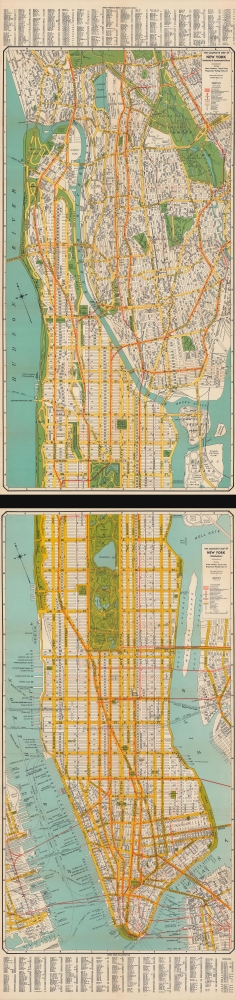
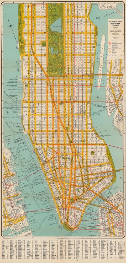
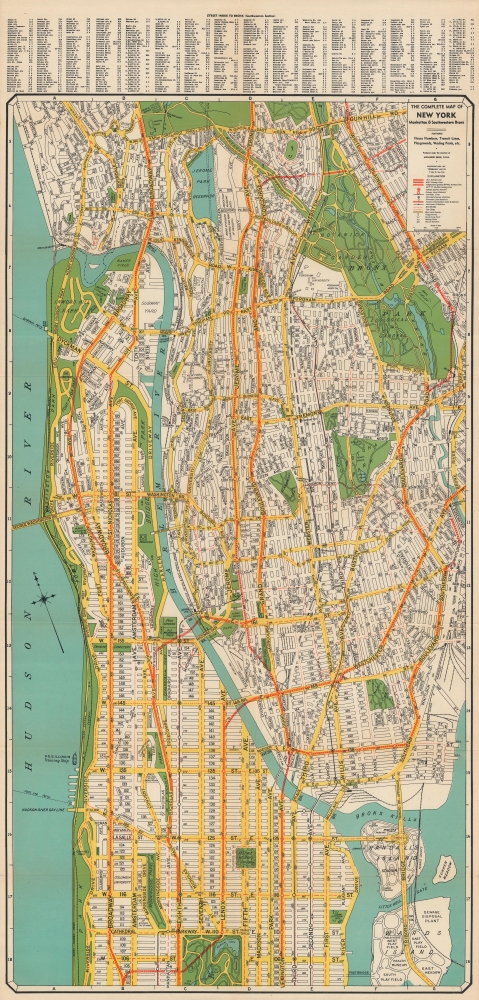
The complete map of New York (Manhattan) / The complete map of New York and Southwestern Bronx.
1939 (dated) 72 x 17.5 in (182.88 x 44.45 cm) 1 : 15000
1939 (dated) 72 x 17.5 in (182.88 x 44.45 cm) 1 : 15000
Description
A rare, large-format two-sheet 1939 folding map of Manhattan and the southern Bronx issued by the Geographia Map Company. Although falling squarely within the 'age of anxiety' defined by the Great Depression and geopolitical tensions, the map also highlights the great advances made in the city's urban planning and transportation infrastructure in the preceding years. It also coincides with the 1939 - 1940 New York World's Fair, an expensive and well-promoted event that was meant to lift spirits and the economy.
A Closer Look
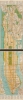
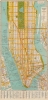
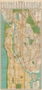
The lower sheet displays Manhattan up to 104th Street, with portions of New Jersey, Brooklyn, Queens, and small nearby islands, while the upper sheet depicts Manhattan above 104th Street and the southern half of the Bronx. Details include roads, bridges, tunnels, piers, railways, subway and elevated lines, parks, public institutions, subway and railroad stations, and 'house numbers,' indicating addresses by city block. An alphanumeric grid in the border corresponds to a street index at bottom on the lower sheet and at top on the upper sheet.Modernizing New York's Infrastructure
Although ferries and steamship lines are meticulously noted, the city was shifting decidedly towards underground subways and automobiles as the primary means of transportation, including interborough and interstate travel. The city's subways and elevated trains were themselves transforming rapidly, as subway lines moved towards consolidation, a process completed with the creation of the New York City Transit Authority in 1953. The Second, Third, and Columbus Avenue Elevated Lines appear here, but were phased out in the following years in favor of quieter and cleaner subway lines. Meanwhile, the Lincoln, Holland, and Queens Midtown Tunnels, along with the George Washington and Triborough Bridges, had all opened in the preceding years, joining earlier bridges in connecting the city's boroughs and the city with New Jersey.The 1939 - 1940 New York World's Fair
Queens is not included on this map, but Geographia nevertheless likely intended the map to be used by visitors to New York for the 1939 World's Fair, taking place in a cleared ash dump that was transformed into exhibition grounds (today's Flushing Meadows-Corona Park). Despite the glum of the Great Depression and the Second World War, which began in Europe while the fair was in progress, the fair's emphasis on progress, science, and new technologies (including television) left a deep impression. The city itself reflected these virtues, as efficiency and progress were the orders of the day.Publication History and Census
This map was produced and published by the Geographia Map Company in 1939. Geographia published a variety of maps of New York City and its boroughs in multiple editions in the 1930s - 1950s, including the lower sheet by itself, which Geographicus has previously offered. However, this map seems to have not survived well and was only issued once. We see only one institutional holding, at the New York Public Library.Cartographer
Geographia, Ltd. (1911 - 1985) was a London-based cartographic publishing firm. The company was founded by Alexander Gross (1879 - 1958), a Hungarian immigrant to the United Kingdom. Geographia Ltd. is best known for its folding pocket maps and globes. Many of his maps were drawn by a mysterious 'Mr. Fountain', of whom we have been able to discover little. Gross ran into financial problems around 1940, likely associated with World War II, and relocated to offices in New York at 11 John Street. There, he issued a large corpus of U.S.-focused maps and city plans. By the 1940s, the branch in the United States had been renamed the Geographia Map Company and experienced rapid growth. By the 1950s, Geographia had published maps of dozens of cities across the United States. In 1987, the British branch was bought out by Harper Collins and continues to produce maps under the Collins Bartholomew imprint. Rand McNally bought the New York-based Geographia Map Company in the late 1980s. However, its original owners repurchased the Geographia Map Company a few years later and still operate the company in Hackensack, New Jersey. Gross's daughter, Phyllis Isobella Gross / Pearsall (1906 - 1996), founded the Geographers' A-Z Map Company in London, the largest independent map publisher in the United Kingdom. In the UK, their offices were originally at 33 Strand, where they published as 'Geographia Designing and Publishing Company Ltd.'. Later, by 1933, they had relocated to 55 Fleet Street, where they remained until at least 1937. By 1942, they relocated to 167 Fleet Street, followed by 114 Fleet Street by 1964. It is of note that many of the Geographia Ltd. maps feature a peculiar dating system wherein the letters in the world CUMBERLAND correspond to the numbers 1234567890, such that a date is rendered by substitution, so A.MU would break out like this A = 8, M = 3, U = 2, so 8.32 or, August 1932. Or, MM.YY e.g. E.MC = 5.31 = May 1931. More by this mapmaker...
Condition
Very good. Slight wear along fold lines. Accompanied by original cover.
References
OCLC 871038517.