This item has been sold, but you can get on the Waitlist to be notified if another example becomes available, or purchase a digital scan.
1898 Norris Peters Map or Plan of Manila, Philippines - Spanish-American War
Manila-norrispeters-1898$125.00

Title
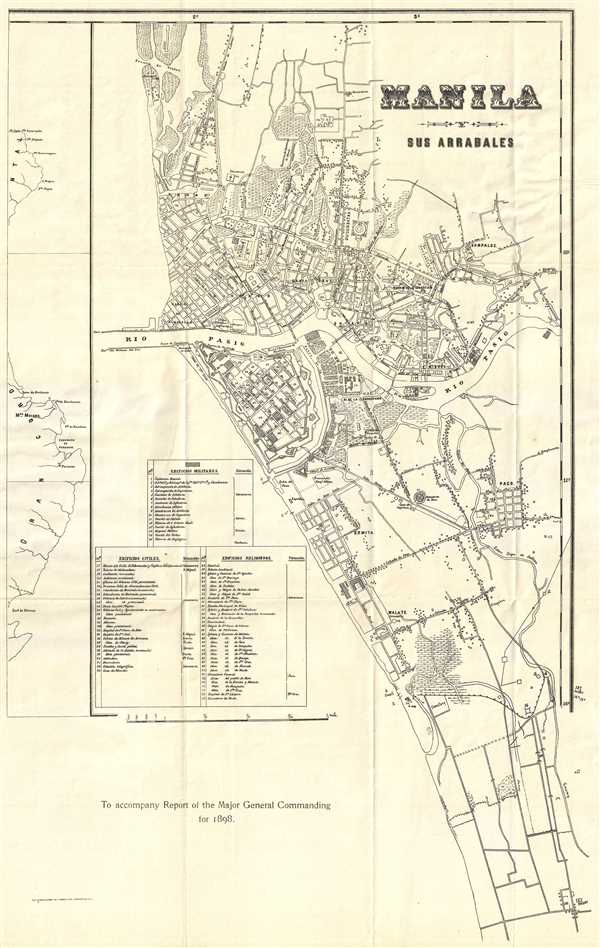
Manila y Sus Arrabales. To accompany Report of Major General Commanding for 1898.
1898 (dated) 22.5 x 14 in (57.15 x 35.56 cm) 1 : 10000
1898 (dated) 22.5 x 14 in (57.15 x 35.56 cm) 1 : 10000
Description
This is an 1898 Norris Peters edition of a Francisco J. de Gamoneda map or city plan of Manila, the Philippines and was printed to accompany the report of the Major General commanding in the Philippines, who was also the military governor. The map depicts the city from the Barrio de S. Nicolas to Pasay and from the Bocana de Vistas to Pasay. The Pasig River divides the city in two, just as it does today. Highly detailed, roads, neighborhoods and civic sites, such as cemeteries, are labeled. There is an index along the left margin which lists seventy-seven military, civil, and religious sites around the city.
Publication History
The map was printed by The Norris Peters Company of Washington D.C. to accompany a report of the Major General Commanding in the Philippines for 1898. It was extracted from an inset on the 1898 Francisco J. de Gamoneda wall map of the Philippines.Cartographer
Norris Peters (c. 1834 – July 15, 1889) was a Washington D.C. based photo-lithographer active in the late 18th and early 19th century whom Scientific American called 'one of Washington's most eccentric and mysterious figures.' Peters was born and educated in Pennsylvania. He relocated as a young man to Washington D.C. where he took work as an examiner for the United States Patent Office. During his work with the patent office he became fascinated with the emergent process of photolithography. In 1869 Peters secured substantial venture capital of about 100,000 USD from an unknown investor and founded The Norris Peters Company at 458 Pennsylvania Avenue. Their printing offices have been described as 'unequaled in this or any other country.' From these offices Peters pioneered the development of American photo-lithography. For nearly a generation he held a near monopoly on government photo-lithographic printing. Among their more notable contracts included numerous maps for congressional reports, maps of the U.S. Coast Survey, maps of the U.S. Geological Survey, Mexican currency for the State of Chihuahua, and the Official Gazette of the Patent Office. Peters also maintained an interesting social life and was a confidant to many of the most powerful figures in Congress. He was also a bon vivant known for being an excellent cook and hosting lavish dinners, the invitations to which were 'never declined'. Despite being socially active he never married and died a confirmed bachelor. Following Peters' death in 1889 his business was taken over by Henry Van Arsdale Parsell who administered it until his own death in 1901. The company then merged with Webb & Borcorselski, another D.C. lithography firm, and was renamed Webb & Borcorselski-Norris Peters. They continued to publish under this name well into the mid 20th century. More by this mapmaker...
Condition
Very good. Wear along original fold lines. Blank on verso.
References
OCLC 39343378.