This item has been sold, but you can get on the Waitlist to be notified if another example becomes available, or purchase a digital scan.
1938 U.S. Coast and Geodetic Survey Nautical Chart or Map of Luzon, Philippine Islands
ManilaBayTaiwan-uscgs-1938$375.00


Title
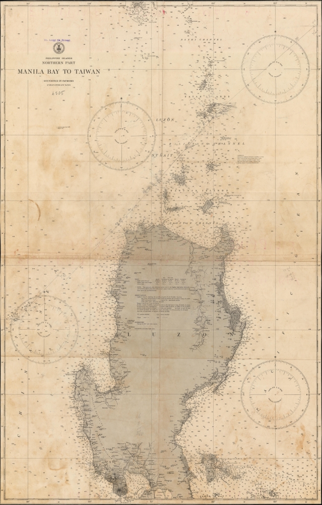
Philippine Islands. Northern Part. Manila Bay to Taiwan.
1938 (dated) 43.25 x 27.75 in (109.855 x 70.485 cm) 1 : 800000
1938 (dated) 43.25 x 27.75 in (109.855 x 70.485 cm) 1 : 800000
Description
This is a 1938 U.S. Coast and Geodetic Survey nautical map of Luzon, the Philippines. It represents one of the best nautical charts of Luzon predating World War II (1939 - 1945).
A Closer Look
Coverage embraces from the China Sea to the Pacific Ocean and from southern Taiwan to Manila and Manila Bay. Coastal locations throughout are labeled, including recognizable mountains, towns, capes, and points. Manila and Corregidor Island are both identified. Only a few years later, these islands became foci of the Pacific War. Numerous islands are identified along the coast and north to Taiwan, including the Polillo Islands, and the Babuyan Islands, and Batan Islands.Publication History and Census
This map was created by the U.S. Coast and Geodetic Survey and published in 1938. Only one example is cataloged in the OCLC and is part of the collection at Stanford University.Cartographer
The Office of the Coast Survey (1807 - present) founded in 1807 by President Thomas Jefferson and Secretary of Commerce Albert Gallatin, is the oldest scientific organization in the U.S. Federal Government. Jefferson created the "Survey of the Coast," as it was then called, in response to a need for accurate navigational charts of the new nation's coasts and harbors. The spirit of the Coast Survey was defined by its first two superintendents. The first superintendent of the Coast Survey was Swiss immigrant and West Point mathematics professor Ferdinand Hassler. Under the direction of Hassler, from 1816 to 1843, the ideological and scientific foundations for the Coast Survey were established. These included using the most advanced techniques and most sophisticated equipment as well as an unstinting attention to detail. Hassler devised a labor intensive triangulation system whereby the entire coast was divided into a series of enormous triangles. These were in turn subdivided into smaller triangulation units that were then individually surveyed. Employing this exacting technique on such a massive scale had never before been attempted. Consequently, Hassler and the Coast Survey under him developed a reputation for uncompromising dedication to the principles of accuracy and excellence. Unfortunately, despite being a masterful surveyor, Hassler was abrasive and politically unpopular, twice losing congressional funding for the Coast Survey. Nonetheless, Hassler led the Coast Survey until his death in 1843, at which time Alexander Dallas Bache, a great-grandson of Benjamin Franklin, took the helm. Bache was fully dedicated to the principles established by Hassler, but proved more politically astute and successfully lobbied Congress to liberally fund the endeavor. Under the leadership of A. D. Bache, the Coast Survey completed its most important work. Moreover, during his long tenure with the Coast Survey, from 1843 to 1865, Bache was a steadfast advocate of American science and navigation and in fact founded the American Academy of Sciences. Bache was succeeded by Benjamin Pierce who ran the Survey from 1867 to 1874. Pierce was in turn succeeded by Carlile Pollock Patterson who was Superintendent from 1874 to 1881. In 1878, under Patterson's superintendence, the U.S. Coast Survey was reorganized as the U.S. Coast and Geodetic Survey (C & GS) to accommodate topographic as well as nautical surveys. Today the Coast Survey is part of the National Oceanic and Atmospheric Administration or NOAA as the National Geodetic Survey. More by this mapmaker...
Condition
Good. Soiling. Wear along original fold lines. Cut to neatline. Verso repair at fold intersection. Manuscript on recto and verso.
References
Stanford University Library G8061 .P5N 1938 .U4. OCLC 914130997.