
1877 Astort Double Hemisphere World Map

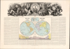

Mapa Mundi. Hemisferio Occidental. Hemisferio Oriental.
Distributing Scientific Advances to a Popular Audience.
- Digital Map Information
- Suitable for large format printing
- Full resolution TIFF file
- ICC color profile embedded
- Delivered instantly via download link
Distributing Scientific Advances to a Popular Audience.
This 1877 Spanish-language double-hemisphere chromolithographic map of the world, drawn by José Pilar Morales, engraved by Otto Neussel, and published in Madrid by Astort Hermanos, combines a scientific primer with a panoramic allegorical depiction of the continents. Prepared as the opening map of Juan Vilanova y Piera's Atlas Geográfico Universal, it introduces the Earth through its physical structure, geological history, and astronomical movements. The atlas brought European scientific cartography methods and subjects to Spanish readers through an ambitious combination of explanatory writing, thematic mapping, and elaborate illustration. However, the map's extensive accompanying text also treads carefully, offering some evidence for the theory of evolution without explicitly endorsing it.A Closer Look
The main map divides the world into western and eastern hemispheres with color-shading to distinguish continents. Two smaller hemispheres above offer oblique views of the Earth to display the North and South Poles. Faithful to existing scientific knowledge, only the rough outline of the coast of Antarctica is traced, with only known areas like Victoria Land, Wilkes Land, Enderby Land, and the South Shetland region mapped. Elsewhere, despite the small format, it includes considerable detail, as with the African Great Lakes and numerous individually named Pacific archipelagos. The main map identifies its reference meridian with the island of Hierro, whereas the subsidiary hemispheres use Paris. The accompanying text acknowledges competing national meridians and reports a proposal by the Sociedad Geográfica de Madrid to restore Hierro as a common reference. Below the map is a comparative mountain diagram, with color-shading corresponding to the continents on the map. A darker foreground profile gives Spain particular prominence, placing Mulhacén, the Castilian plateaus, and familiar towns beneath the much greater elevations of the world's mountain systems. Small plumes identify selected volcanic summits.A Scientific Introduction to the Earth
The surrounding Spanish text provides notes on geology, climate, glaciers, fossils, latitude and longitude, and astronomy. Metaphors sensible to contemporary readers are used to explain these aspects of the Earth, imagining it as a cannonball and a steam locomotive. The discussion of successive faunas and floras is especially revealing, as it presents transformation from earlier organisms and renewed creation as alternative explanations, without resolving the question. This passage bears the strong influence of Vilanova y Piera (1821 - 1893), the atlas's scientific director and a professor of paleontology at Madrid's Universidad Central. Vilanova opposed evolutionary theory while engaging with it as a scientific question, a position distinguished by the Universitat de València from more overtly ideological forms of contemporary opposition.The Allegorical Panorama
A broad monochrome composition crowns the sheet. At its center, a seated female figure holds a globe and points toward a surrounding ring of astronomical symbols, flanked by winged children carrying torches. Around her, personifications and attributes connect geographical knowledge with agriculture, industry, navigation, and the wider natural world. The continental imagery draws on established European conventions: an elephant and incense-bearing woman evoke Asia, a feathered figure with a large bird evokes America, and an African figure appears beside a feline, with pyramids rising behind, and so on.Chromolithography
Chromolithography, sometimes called oleography, is a color lithographic technique developed in the mid-19th century. The process involved using multiple lithographic stones, one for each color, to yield a rich composite effect. Oftentimes, the process would start with a black basecoat upon which subsequent colors were layered. Some chromolithographs used 30 or more separate lithographic stones to achieve the desired product. Chromolithograph color could also be effectively blended for even more dramatic results. The process became extremely popular in the late 19th and early 20th centuries when it emerged as the dominant method of color printing. The vivid color chromolithographic printing produced made it exceptionally effective for advertising and propaganda imagery.Publication History
This map was prepared by Morales under the direction of Vilanova y Piera, with engraving by Otto Neussel, about whom little is known. Ginés Ruiz is recorded as the map printer and G. Estrada as the typographic printer. The atlas was published in 1877 by Astort Hermanos, with the present map appearing as the first. This map is independently cataloged at the University of Texas at Arlington, Biblioteca Nacional de España, Universidad de Granada, Instituto Geográfico Nacional, and the Museo Naval de Madrid.Cartographers
José Pilar Morales Ramírez (1823 - 1881) was a Spanish cartographer, draftsman, engraver, and qualified director of local road works, active principally in Madrid during the mid-to-late 19th century. Born in Santa Cruz de Mudela, Ciudad Real, he completed two courses at Madrid's School of Architecture and subsequently obtained qualifications as a master builder and director of local roads from the Real Academia de Bellas Artes de San Fernando. In 1849 he joined the workshops producing the Atlas de España under Francisco Coello (1822 - 1898), remaining until 1860 and rising to oversee engraving and lithography. Supported by Coello's recommendation, he entered government cartographic service as a draftsman with the Comisión de Estadística General del Reino on January 29, 1861, becoming first draftsman of the Dirección de Operaciones Geográficas five years later. From 1862 to 1866 he taught drawing at the Escuela Especial de Topografía Catastral, where his Manual de dibujo topográfico (1864) served as a textbook. His commercial cartography included Plano de Madrid, first issued in 1866 at 1:10,000 and subsequently revised to record changes within the older city and the development of its planned expansion; its street indexes and reference grid also made it a practical urban guide. In early 1869 he helped prepare the finished cadastral drawings of the royal estate of Riofrío. His government appointment ended on March 9, 1869, when the drawing section was abolished, and from 1870 he continued engraving privately. A member of the Sociedad Geográfica de Madrid, Morales died in 1881; his death was reported at the Society's meeting of February 1. Further Details...
Astort Hermanos (fl. c. 1874 - 1882) was a Spanish publishing and printing firm based in Madrid, active in illustrated geographical and reference publishing during the late 19th century. Its principals were the brothers Antonio Astort and Federico Astort (1837 - 1903), the latter a tenor and singing teacher who joined Antonio in the Madrid publishing business after returning from Uruguay in 1874. Their offices were at Plaza de la Armería, 4. The firm's principal cartographic undertaking was the Atlas geográfico universal, published from 1877 with text directed by Juan Vilanova y Piera (1821 - 1893), artistic work directed by Otto Neussel, geographical drawing by José Pilar Morales, and chromolithography by Ginés Ruiz. Combining regional and continental maps with thematic mapping and astronomical illustrations, the atlas brought together scientific exposition and elaborate illustrated cartography. The brothers promoted its publication with a banquet for the Madrid press in late November 1877, and installments continued to appear in 1878. At their request, the Dirección General de Instrucción Pública referred the atlas to the Sociedad Geográfica de Madrid for examination in April 1879. Their broader publishing program included dictionaries, illustrated literature, and works concerning the Americas. The business was declared bankrupt by the court of Madrid's Latina district on September 23, 1879. Printing nevertheless continued under the name Sindicatura de Astort Hermanos, documented in 1882, distinguishing the firm's later administration from its earlier operation by the brothers. Further Details...
Litografía de Ginés Ruiz (fl. 1870 - c. 1888) was a Spanish lithographic printing establishment based in Madrid during the last third of the 19th century, producing maps, atlases, scientific illustrations, and popular prints. Its cartographic work included the map Strasbourg, published in La Ilustración Española y Americana on September 15, 1870. The firm's principal documented atlas commission was the chromolithographic printing of the Atlas Geográfico Universal, published in Madrid by Astort Hermanos in 1877, with text directed by Juan Vilanova y Piera (1821 - 1893), artistic direction by Otto Neussel, and geographical drawing by José Pilar Morales. This substantial folio atlas contained 35 double-page maps encompassing countries and continents, thematic world geography, and the solar system. The establishment also printed provincial cartography associated with Francisco Boronat y Satorre's España geográfica histórica ilustrada. A geological map, Mares numulíticos: España y sus antiguos mares, credited to Federico de Botella y de Hornos (1822 - 1899), with geographical information by Francisco Coello (1822 - 1898), bears the firm's imprint and is provisionally dated about 1888. Beyond cartography, the workshop produced theatrical portraits, caricatures, and devotional images. Its address appears as Calle Silva, 49, on publications of 1871 and Calle Espíritu Santo, 18, on work issued in 1877. Further Details...
Source
Vilanova y Piera, Juan, dir., Atlas Geográfico Universal, (Madrid: Editores Astort Hermanos) 1877.
Condition
Very good. Few marginal mends not impacting printed image. Else excellent.
References
OCLC 431371652. Instituto Geográfico Nacional, Biblioteca, NC475(0001-mapa). Museo Naval de Madrid, A-10176. Hernando, A., 'Los atlas temáticos del siglo XIX: saber científico y representación cartográfica', Revista de Geografia, XXXII - XXXIII (1998 - 1999), pp. 125 - 127, 135.