This item has been sold, but you can get on the Waitlist to be notified if another example becomes available, or purchase a digital scan.
1706 de La Feuille Map of the World on Hemisphere Projection
Mapemonde-lafeuille-1706$300.00

Title
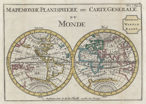
Mapemonde Planisphere ou Carte Generale du Monde / Generale Wareld Kaart.
1706 6 x 8.5 in (15.24 x 21.59 cm)
1706 6 x 8.5 in (15.24 x 21.59 cm)
Description
A very scarce later, c. 1706, edition of a map of the world on a hemisphere projection first issued by Daniel de La Feuille in 1702. Much of the coastlines are plotted conjecturally at best. Features a massive California in Island form. Further north the American Northwest Coast is blank suggesting though not specifically detailing a Northwest Passage. Antarctica (Terres Antarctiques) seems to merge into the incomplete line representing New Zealand's eastern coast. The coastline of eastern Australia is largely indistinct and undefined. In Asia the Great Wall of China is drawn in and Japan is labeled though only loosely defined. In Polynesia, the Solomon Islands appear but no other island groups are identified. This map was originally prepared for inclusion as chart no. 2 in the 1702 edition of De la Feuille's Atlas Portatif. This particular map is from the 1706 reissue as indicated by the addition of the Dutch 'Generale Wareld Kaart.' to the title.
Cartographer
Daniel de La Feuille (1640 - 1709) was born of Huguenot stock in Sedan (L'Ardennes), France. As a young man he apprenticed as a watchmaker. In 1663 La Feuille married Charlette Marlet, the daughter of a local carpenter. Twenty years later, in 1683, facing religious prosecution of Huguenots in France, the family fled to Amsterdam. By 1686 Daniel had become a burgher (citizen) of the city and established himself as an engraver, publisher, and art dealer. Not long after, in 1691, he was admitted into the Booksellers Guild. Though we are primarily concerned with his cartographic work here, his masterpiece is considered to be Devises et emblems, a collection of symbols and designs mostly likely intended as templates for silversmiths, engravers, and watchmakers. His cartographic work includes numerous individual maps and atlases, many of which continued to be published and republished well after his death in 1709. He was succeeded by his sons Jacob de la Feuille (1668 - 1719) and Paul de La Feuille (1688 - 1727). More by this mapmaker...
Condition
Very Good condition. Minor discoloration along the original folds – see photo. Minor fold separation limited to wide marginal region. Original plate-mark visible. Else clean and beautiful.