This item has been sold, but you can get on the Waitlist to be notified if another example becomes available, or purchase a digital scan.
1787 Jaugeon / Desnos Wall Map of the World in Hemispheres
MappeMonde-desnos-1786$12,500.00

Title
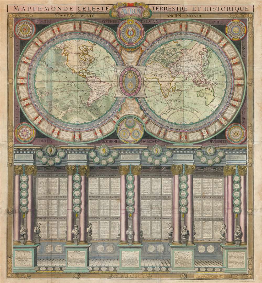
Mappe-Monde Celeste Terrestre et Historique.
1786 (dated) 42.5 x 39 in (107.95 x 99.06 cm) 1 : 35000000
1786 (dated) 42.5 x 39 in (107.95 x 99.06 cm) 1 : 35000000
Description
A stunning large format wall map of the world in six panels issued in 1786 by Charles Desnos and Nicolas Jaugeon. Described by map historian Rodney W. Shirley as 'a veritable compendium of a map,' this is one of the most richly informative cartographic productions ever issued. The map consists of a double hemisphere map projection surrounded by no less than 60 Aeoli windheads, astronomical data on constellations, cosmic systems, and other charts - intentionally placing the world in the context of the greater cosmos. Its elegant presentation conveys confidence in the human capacity to describe not only the Earth, but the cosmos itself. The double hemisphere map rests upon Corinthian columns, underscoring the classical foundations of western scientific thought, here augmented by new discovery. The unique, neo-classical motif is carried through to the bottom half of the engraving, where panels of text are set within a portico supported by Corinthian columns. Completing the illusion are a coffered roof and a patterned tile floor. At the base of the columns there busts and accounts of the great explorers, among them Columbus, Magellan, and Vasco de Gama.
On the Map
The map here is significantly updated over earlier editions to reflect the discoveries of Captain James Cook - a watershed moment in cartographic history. All three of Cook's great voyages completed between 1768 and 1779 are noted. In North America the Pacific Northwest is beginning to take on recognizable form. Australia eastern coast is revealed, although Tasmania remains attached to the mainland. The borders of New Zealand are also clarified, and Antarctica appears for the first time. Nonetheless, there remain deep cartographic errors throughout, particularly in Asia and inland in Africa, South America, and North America. The Caspian Sea is still somewhat circular, the apocryphal Laguna de Xaraies appears in South America, and the interiors of Africa and American are mostly blank. Even so, this map exhibits a considerable advancement, in that previous generation cartographic speculation, used to fill in the map for want of actual exploratory data, has here been much reduced. Unlike the earlier editions, there is, for example, no Lake Parima (El Dorado) in South America, or Ptolemaic mapping of the Nile's sources in Africa.Publication History and Census
This map was first published by Nicolas Jaugeon in Paris in 1688. Although few examples of the 1688 edition survive, it is likely that it featured only the double hemisphere map, not the extensive text and neo-classical imagery below. The map was most likely engraved by Jean Crépy (1660 - 1739), with new plates either engraved or modified by others for the different editions. It appears that the extensive lower portions of the map were engraved by Albert Jouvin de Rochefort (c. 1640 - c. 1710) for Alexis-Hubert Jaillot's (c. 1632- 1712) c. 1690 edition. Jaillot issued subsequent editions in 1718, 1730, and 1758. After Jaillot's death, his plates passed to Louis Charles Desnos (1725 - 1805), who hired Louis Brion de la Tour (1743 - 1803) to re-engrave the map portion of the chart to reflect the discoveries of Captain James Cook. The present example is the Desnos issue, of which there is only one state, 1786.CartographerS
Nicolas Jaugeon (fl. c. 1680 - 1710) was a typographer, mathematician, and engraver active in Paris in the late 17th and early 18th centuries. Jaugeon is best known for the 1692 invention of the typeface Romain du Roi, which is best known today as Times New Roman. The typeface was revolutionary at the time as it abandoned the artistic principles of calligraphy to instead draft each letter on a uniform mathematical platform. The typeface was initially reserved for the French Royal Press, Imprimerie Royale, but was later adopted by others. Jaugeon was also a prominent and active member of the French Academy of Sciences. He cartographic corpus appears limited to a single, but spectacular, map of the work published in 1688. Another Jaugeon, Jacques, also appears to be associated with the development of Romain du Roi, and the two are often conflated as the same individual, suggesting further research into the elusive but important individual is required. More by this mapmaker...
Louis Charles Desnos (1725 - April 18, 1805) was an important 18th century instrument maker, cartographer and globe maker based in Paris, France. Desnos was born in Pont-Sainte-Maxence, Oise, France, the son of a cloth merchant. From April of 1745 he apprenticed at a metal foundry. Desnos married the widow of Nicolas Hardy, sone of the map, globe, and instrument seller Jacques Hardy. Desnos held the coveted position of Royal Globemaker to the King of Denmark, Christian VII, for which he received a stipend of 500 Livres annually. In return Desnos sent the King roughly 200 Livres worth of maps, books and atlases each year. As a publisher, Desnos produced a substantial corpus of work and is often associated with Zannoni and Louis Brion de la Tour (1756-1823). Despite or perhaps because of the sheer quantity of maps Desnos published he acquired a poor reputation among serious cartographic experts, who considered him undiscerning and unscrupulous regarding what he would and would not publish. Desnos consequently had a long history of legal battles with other Parisian cartographers and publishers of the period. It is said that he published everything set before him without regard to accuracy, veracity, or copyright law. Desnos maintained offices on Rue St. Jacques, Paris. Learn More...
Louis Brion de la Tour (1743 - 1803) was the Cartographer Royal to the King of France, his official title being Ingenieur-Geographe du Roi. Despite a prolific cartographic career and several important atlases to his name, little is actually known of his life and career. He may have been born in Bordeaux. His son of the same name was born in 1763 and published until his death in 1832. It is nearly impossible to distinguish the work of the father from the work of the son, as both used the same imprint and were active in roughly the same period. Much of their work was published in partnership Louis Charles Desnos (fl. 1750 - 1790). Their most notable work is generally regarded to be his 1766 Atlas General. Learn More...
Albert Jouvin de Rochefort (c. 1640 - c. 1710) was a French cartographer and government official active during the second half of the 17th century. Rochefort is a little known figure who served as Treasure to the King of France at Limoges from 1675 to 1702. In this capacity he traveled extensively throughout France and Europe in General, publishing an account of his travels with the firm of Thierry, Louis and Claude Barbin Billain. He apparently also traveled extensively in Egypt, the Holy Land, and Turkey. He produced several important maps, most of which are on a massive scale, to illustrate his cardinal work, Le voyageur d'Europe, où sont les voyages de France, d'Italie et de Malthe, d'Espagne et de Portugal, des Pays Bas, d'Allemagne et de Pologne, d'Angleterre, de Danemark et de Suède. In 1672-5 Rochefort issued a monumental plan of Paris in nine panels, Paris et ses Environs followed by a smaller plan in 1697, Nouveau plan de Paris. Apparently a portrait of Rochefort is preserved in the National Library of France. Learn More...
Condition
Good. Some wear on original fold lines. Multiple sheets joined. Laid down on linen.
References
Shirley, Rodney W., The Mapping of the World: Early Printed World Maps 1472-1700, #538. OCLC 962041678.