This item has been sold, but you can get on the Waitlist to be notified if another example becomes available, or purchase a digital scan.
1865 Kossak Map of the Marches of General Sherman during the American Civil War
MarchesWTSherman-kossak-1865$550.00

Title
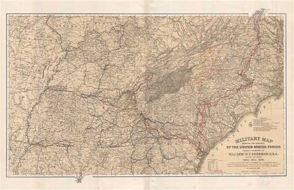
Military Map Showing the Marches of the United States Forces Under Command of Maj. Gen. W. T. Sherman. U.S.A. During the Years 1863, 1864, 1865.
1865 (dated) 24.5 x 37.5 in (62.23 x 95.25 cm) 1 : 1584000
1865 (dated) 24.5 x 37.5 in (62.23 x 95.25 cm) 1 : 1584000
Description
This is a separate issue 1865 William Kossak and United States Corps of Engineers map of the southeastern United States tracing the movements of Union Army forces under the command of Major General William Tecumseh Sherman in 1863, 1864, and 1865. Depicting from Missouri, Arkansas, and Louisiana to North Carolina and the Atlantic Ocean and from Missouri, Illinois, Indiana, Kentucky, Ohio, and Virginia to Mobile Bay, the level of detail employed by Kossak, and John B. Muller, a draughtsman, is astounding. The routes followed by General Sherman's units, which include the 4th, 14th, 15th, 16th, 17th, and 20th Army Corps are illustrated, along with Sherman's movement on Atlanta (a massive operation during which he orchestrated the movements of three separate armies), and Sherman's pursuit of Confederate General John Bell Hood. The movements of General J. H. Wilson's Cavalry Corps and those of General G. Stoneman's Cavalry Corps are also depicted, along with Union and Rebel fortifications.
Sherman's involvement in the siege of Vicksburg, the Chattanooga Campaign, the Atlanta Campaign, the March to the Sea, and the Carolinas Campaign are all traced, allowing the viewer the opportunity to see the vast amounts of territory General Sherman covered during these three years. Sherman also accepted the surrender of Confederate General Joseph E. Johnston and the Army of the Tennessee at Bennet Place near Durham Station (Durham), North Carolina. Finally, Sherman and his men marched from North Carolina to Washington, D.C., where they took part in a massive parade celebrating the end of the war.
A highly detailed representation of a pivotal part of American history, myriad cities, towns, and villages throughout the region are labeled. Rivers, lakes, hills, and mountain ranges are also depicted, creating a sense of the terrain that Sherman and his men had to negotiate in order to achieve success. Railroads, one of the key new technologies in both the Union and Confederate war effort, snake their way across the map, connecting urban centers with small towns and making rapid redeployment of troops more feasible than ever before. Numerous Civil War battles occurred either at rail junctions or close by, and one of the major objectives of Sherman's Atlanta Campaign and the March to the Sea was to cripple the rail network in the region in order to cut off Confederate armies (particularly General Robert E. Lee's Army of Northern Virginia) from one of their last major supply centers.
This map was drawn by William Kossak and John B. Muller and engraved by H.C. Evans and F. Courtenay of the Army Corps of Engineers under the direction of Brevet Major William LeBaron Jenney in 1865. We have been able to locate this map in institutional collections but we believe that it has never before been available on the market.
CartographerS
William Kossak (fl. c. 1860 - 1863) was born in Prussia and was apparently a refugee from the political turmoil that cut through the region in 1848. Upon outbreak of the American Civil War, Kossak immediately volunteered and received a commission as a Lieutenant in the 5th Missouri Infantry on May 20, 1861. By August he had earned a promotion to Captain and had been given the position of Additional Aide-de-Camp in the volunteer Engineers. He went on to serve on the staffs of the most celebrated generals of the western theater, including Grant and Sherman. Kossak participated in many campaigns during the war, including at Fort Henry, Fort Donelson, Shiloh, Corinth, Vicksburg, the Atlanta Campaign, and the March to the Sea. During most of this time Kossak reported directly to General Sherman and he earned personal commendations from both General Sherman and General Grant. He attained his highest position, Chief Engineer of the 17th Army Corps, during Sherman's campaigns in Georgia. Little is known about Kossak's life before or after his military service. More by this mapmaker...
William LeBaron Jenney (September 25, 1832 - June 14, 1907) was an American architect and engineer who, in 1884, built the first skyscraper and became known as the Father of the American skyscraper. Born in Fairhaven, Massachusetts to William Proctor Jenny and Eliza LeBaron Gibbs, Jenny was educated at Phillips Academy in Andover, before attending the Lawrence School at Harvard. Before finishing at Harvard he transferred to the École Centrale des Arts et Manufactures (École Centrale Paris), where he studied engineering and architecture. While in Paris he studied the latest iron construction techniques along with the classical functionalist doctrine of Jean-Micolas-Louis Durand, who was Professor of Architecture at the École Polytechnique. Jenney graduated in 1856, one year after his classmate Gustave Eiffel, who would go on to design the Eiffel Tower. Jenney returned to the United States in 1861 to join the Union Army. During his service Jenney designed fortifications for both General Sherman and General Grant. Jenney had reached the rank of major by the end of the war and held the position of Engineer-in-Charge of Nashville's Union headquarters. Jenney moved to Chicago in 1867, where he opened his own architectural office with specializations in commercial building and urban planning. During the late 1870s, Jenney began commuting weekly to the University of Michigan, where he started the architecture program and also taught courses. Jenney married Elizabeth 'Lizzie' Hannah Cobb of Cleveland, Ohio on May 8, 1867, with whom he had two children, Max and Francis. Learn More...
Condition
Very good. Verso reinforcement of original centerfold. Blank on verso.
References
LOC G3866.S5 1865 .K6. Stephenson, R. W., Civil War Maps; an Annotated List of Maps and Atlases in Map Collections of the Library of Congress, 72. OCLC 761323628.