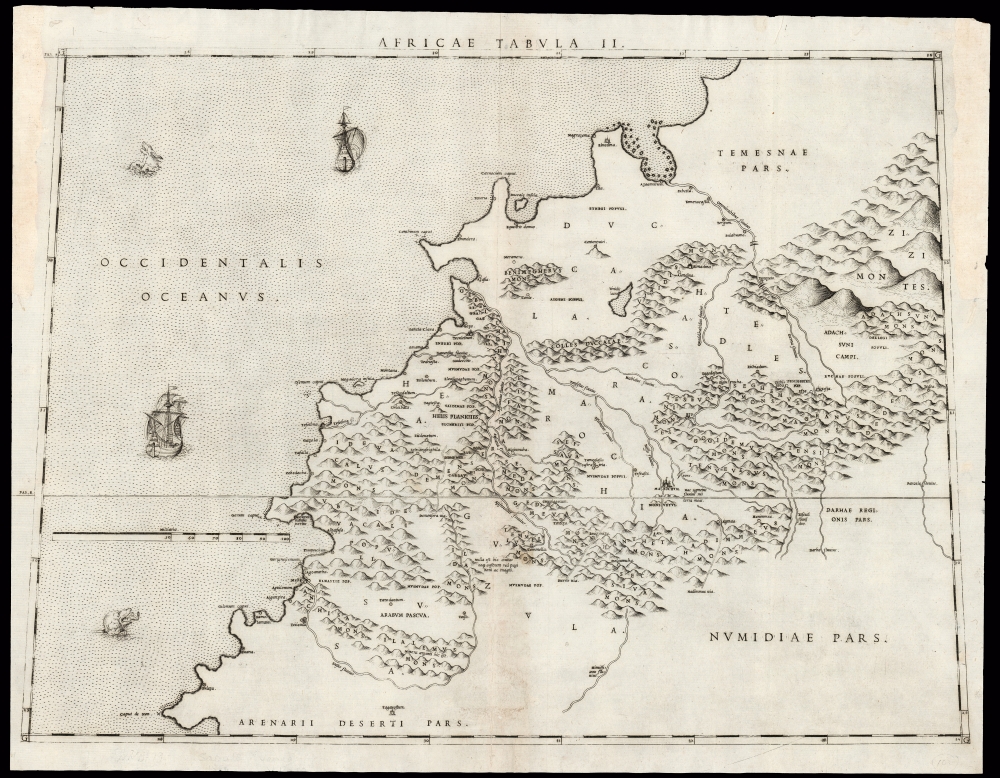
1588 Livio and Giulio Sanuto Map of Morocco and Marrakesh
Marrakesh-sanuto-1588$2,000.00

Title
Africae Tabula II.
1588 (undated) 15.5 x 21 in (39.37 x 53.34 cm) 1 : 1403000
1588 (undated) 15.5 x 21 in (39.37 x 53.34 cm) 1 : 1403000
Description
This is Livio Sanuto's rare and beautiful 1588 map of central Morocco, focusing on Marrakesh and the area lying between the Oum Er-Rbia and the Sous Rivers. The map depicts the rugged western end of the Atlas Mountains with details drawn almost exclusively from the reports of the Berber-Andalusi traveler, diplomat, and author Johannes Leo Africanus (1494 - 1554). It is moreover a strikingly beautiful engraving, a masterwork of Livio's brother Giulio, who engraved all twelve of the maps comprising their atlas of Africa.
A New Map
Though the region had appeared in Ptolemaic geographies and in the works of Gastaldi and Ortelius, Sanuto's map of the lands around Marrakesh was unique in its detail. While Sanuto's map is not the only one to draw on Leo Africanus as a source - Gastaldi and Ortelius also did so - Sanuto was the only 16th-century map to detail this region at this scale. He was also unique in his specific interpretation of Africanus' written reports, and the resulting map resembles no other until it was copied by Sanson in the 17th century. Sanuto's depiction of the continent throughout the twelve maps of his atlas of Africa differed sharply from any contemporaneous map of those areas, the result of his thorough reconsideration of African geography in the light of both conventional and newly available sources - marking it as a unique and underappreciated masterpiece of geographical thought. While not all of his descriptions can have derived from firsthand contact, Leo Africanus' work as a diplomat had brought him as far afield in Africa as Timbuktu, and as a resident of Fez the lands around Marrakesh would have been known to him. It is reasonable that most of this information as found here was the fruit of actual visits.On The Map
Leo Africanus' observations reflect the situation after 1513 but before 1518.. The Portuguese capture of the port of Azemmour and their influence down the coast at the expense of the Wattasid Dynasty can be seen. Albeit filtered through Latin, many of the original Arabic names can be discerned (for example, Ommirabibus for the river Oum er-Rbia). The map becomes less accurate the further it reaches into and beyond the Atlas Mountains, but nevertheless provides a clear representation of the best account of this part of the world.A Bright Light, Dimmed
As published, Sanuto's work was the first such book dedicated solely to Africa. This was not the author's intent, as the work was but one volume of a twelve-volume global geography. If Sanuto were to have applied the same fresh thought to other regions that he applied to Africa, the result would certainly have been an atlas to eclipse that of Ortelius. As it happened, Livio died in 1576 before producing the other volumes, likely a victim of the plague. The completed volume - the set of Africa maps - was published posthumously in 1588, in a single edition. Thus, despite the detail and beauty of Sanuto's Africa maps, they achieved scant recognition. Dutch Golden Age mapmakers instead copied Ortelius's less refined mapping. Improved maps of the African interior did not appear until the 1670s and 80s, with the work of Du Val, Ludolf, and Coronelli. Of Sanuto's work, Bifolco and Ronca offer high praise:...The description of Africa is the best of the sixteenth century and the maps represent a happy synthesis of all the elements then available; hence it is legitimate to conclude that if Sanuto had succeeded in completing the entire work, we would have in it one of the greatest monuments of geography in the period of the Renaissance.
Publication History and Census
This map was composed by Livio Sanuto, and engraved by his brother Giulio for inclusion in their Geografia di M Livio Sanuto Distinta in XII Libri, of which only the Africa volume was published. It is not known when exactly the plates for the Geografia were engraved, but it is thought that Livio prepared the text for the work between 1561 and 1575. Livio died in 1576. The work was published posthumously in 1588 by Damiano Zenaro. We see only one example of this separate map in OCLC, cataloged by the Biblioteca Nacional de España. The complete atlas appears to be reasonably well represented in institutional collections.CartographerS
Livio Sanuto (1520 – 1576) was a Venetian cartographer and scientific instrument maker produced, with his engraver brother, Giulio (fl. 1540-1588) – an array of some of the most important geographical works produced in Venice during the second half of the sixteenth century. These included a 27-inch globe and the 1588 12-sheet atlas, Geografia della Africa. Among Livio and Giulio's works were some, if not all of the maps prepared for Ruscelli's 1561 Ptolemy. More by this mapmaker...
Giulio Sanuto (fl. 1540 – 1580) was a Venetian engraver. He was born the illegitimate son of Cavaliere Francesco di Angelo Sanuto; With his brother, the cartographer and scientific instrument maker Livio Sanuto (1520 – 1576) he produced an array of some of the most important geographical works produced in Venice during the second half of the sixteenth century. These included a 27-inch globe and the 1588 12-sheet atlas, Geografia della Africa. Giulio's career is singluar among Venice's engraves in that it appears to have been equally based on artistic, figurative work as well as his cartographic works. Giulio is more broadly known for a small but sought-after selection of decorative engravings; no more than twelve of these can be attributed confidently to him, including the monumental Apollo and Marsyas, measuring over 1.30 meters wide. Whilst Sanuto's engravings were generally based upon the designs of other artists, his work was both ambitious and grand, and he often signed these works. Learn More...
Johannes Leo Africanus, born al-Hasan Muhammad al-Wazzan al-Fasi, الحسن محمد الوزان الفاسي)(c. 1494 – c. 1554) was a Berber Andalusi diplomat and author who is best known for his 1526 book Cosmographia et geographia de Affrica, later published by Giovanni Battista Ramusio as Descrittione dell’Africa (Description of Africa) in 1550, the 16th century's most authoritative text on the geography of the north parts of Africa. He was born al-Hasan Muhammad al-Wazzan al-Fasin in Granada around the year 1494; his family moved to Fez soon after. There studied at the University of al-Qarawiyyin; As a young man he accompanied an uncle on a diplomatic mission, reaching as far as the city of Timbuktu in the Songhai Empire. 1517 found him working as a diplomat in the service of the Sultan of Fez, on a mission to Constantinople. He was a witness to the Ottoman conquest of Egypt. His return to Tunis in 1518 would be interrupted by his capture by Spanish pirates, and his imprisonment on Rhodes. His erudition saved him from a lifetime as a galley slave: An example for the ages of the value of an education, he was instead sent to Rome and presented to Pope Leo X. He was not only freed, but also given a pension as an inducement to remain in Rome. There he converted to Catholicism, and was in 1520 baptized with the Latin name Johannes Leo de Medicis. Following the death of his patron Leo X in 1521 Leo Africanus traveled Italy four years, and wrote: his works included an Arabic-Hebrew-Latin medical vocabulary, and an Arabic grammar. He returned to Rome in 1526, where he would write his African geography: although it is unlikely that he had firsthand knowledge of every place he described, he certainly would have been in a position to share knowledge of other travelers, and his access to the great library of Timbuktu may have availed him of much knowledge otherwise beyond reach.
Africanus' African geography would remain in manuscript until it was committed to print in Giovanni Battista Ramusio's Voyages as Della descrittione dell’Africa et delle cose notabili che ivi sono, per Giovan Lioni Africano. It would be reprinted five times, and later be published in other languages.
Leo Africanus' life following the completion of his Geography is uncertain. He may have remained in Rome until his death; he may have eluded the 1527 Sack of Rome, returning to Tunis until his death there. Another theory sends him from Tunis back to Morocco, where he still had relatives. Despite his intentions to do so (expressed in the text of his Africa book) Leo Africanus produced no further books that have survived. Learn More...
Source
Sanuto, L., Geografia di M Livio Sanuto Distinta in XII Libri, (Venice: Zenaro) 1588.
Condition
Good; filled worming with virtually no impact on printed image. Margins reinstated at upper left and right, outside of printed image. Else very good.
References
OCLC 796358674. Not in Afriterra. Not in Norwich. Bifolco, S. / Ronca, F. Cartografia e Topografia Italiana del XVI Secolo. pp. 2525-6.