This item has been sold, but you can get on the Waitlist to be notified if another example becomes available, or purchase a digital scan.
1925 Latimer Geological Map of Martha's Vineyard and Nantucket, Massachusetts
MarthasVineyardNantucket-geological-1925$600.00

Title
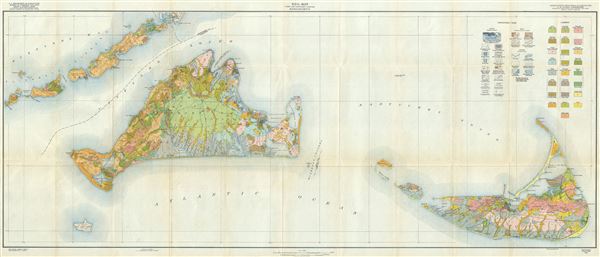
Soil Map Dukes and Nantucket Counties Massachusetts.
1925 (dated) 22 x 53 in (55.88 x 134.62 cm) 1 : 62500
1925 (dated) 22 x 53 in (55.88 x 134.62 cm) 1 : 62500
Description
An uncommon 1925 geological map of Martha's Vineyard and Nantucket, Massachusetts. It also extends to include Wood's Hole and the Elizabeth Islands. Based on surveys completed by the U.S. Geological Survey, this map was compiled, expanded, and updated by W. J. Latimer to reflect soil composition throughout the islands. No less than 25 different soil types are identified. In the process Latimer highlights the most striking difference between the two islands - whereas Nantucket mostly consists of sandy dunes, the larger Martha's Vineyard is primarily loamy arable soil. A. Hoen and Company, prominent Baltimore based government printers, completed the engraving on behalf of Latimer. This map is somewhat uncommon, with only 1 auction record in the past 10 years and just 3 specific entries in the OCLC.
CartographerS
The Office of the Coast Survey (later the U.S. Geodetic Survey) (1807 - present), founded in 1807 by President Thomas Jefferson and Secretary of Commerce Albert Gallatin, is the oldest scientific organization in the U.S. Federal Government. Jefferson created the "Survey of the Coast," as it was then called, in response to a need for accurate navigational charts of the new nation's coasts and harbors. The first superintendent of the Coast Survey was Swiss immigrant and West Point mathematics professor Ferdinand Hassler. Under the direction of Hassler, from 1816 to 1843, the ideological and scientific foundations for the Coast Survey were established. Hassler, and the Coast Survey under him developed a reputation for uncompromising dedication to the principles of accuracy and excellence. Hassler lead the Coast Survey until his death in 1843, at which time Alexander Dallas Bache, a great-grandson of Benjamin Franklin, took the helm. Under the leadership A. D. Bache, the Coast Survey did most of its most important work. During his Superintendence, from 1843 to 1865, Bache was steadfast advocate of American science and navigation and in fact founded the American Academy of Sciences. Bache was succeeded by Benjamin Pierce who ran the Survey from 1867 to 1874. Pierce was in turn succeeded by Carlile Pollock Patterson who was Superintendent from 1874 to 1881. In 1878, under Patterson's superintendence, the U.S. Coast Survey was reorganized as the U.S. Coast and Geodetic Survey (C & GS or USGS) to accommodate topographic as well as nautical surveys. Today the Coast Survey is part of the National Oceanic and Atmospheric Administration or NOAA. More by this mapmaker...
August Hoen and Company (fl. c. 1840 - 1981) was a Baltimore based engraving and lithography firm active in the middle part of the 19th century. A. Hoen and Co. was originally founded by Edward Weber under the name 'E. Weber and Company.' Weber died in the early 1850s and his company was taken over by German immigrant August Hoen (18?? - 1886) and his brothers, Henry and Ernest Hoen. As general interest lithographers, the Hoen firm's corpus includes posters, cigar boxes, sheet music covers, and posters as well as maps. They are best known for their pioneering multi-color lithographic techniques. After the death of August Hoen, the business passed on to his son, Albert Hoen. Another son, Earnest A. Hoen, moved to Richmond, Virginia and opened a branch of the firm there where he was granted a charter to produce Civil War era Confederate Currency. Their contributions to the cartographic field are generally in association with engraving and printing work done for Jacob Monk and the U.S. Geological Survey. The Hoen family maintained an active interest in the firm for the next 100 years or so until it finally filed for bankruptcy in 1981. Learn More...
Source
Latimer, W. J., Soil Survey of Dukes and Nantucket Counties, Mass., 1925.
Condition
Very good. Minor wear on original fold lines. Else clean. Backed with archival tissue.
References
OCLC 17764133.