1822 Franz Pluth Map of Martinique
Martinique-pluth-1822$125.00

Title
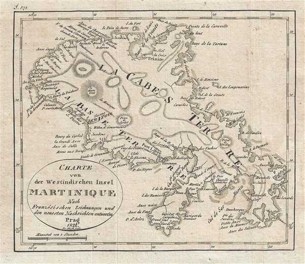
Charte von des Westindischen Insel Martinique.
1822 (dated) 6.75 x 7.75 in (17.145 x 19.685 cm) 1 : 353000
1822 (dated) 6.75 x 7.75 in (17.145 x 19.685 cm) 1 : 353000
Description
This is an 1822 Franz Pluth map of Martinique. Highly detailed, the map depicts the entirety of the island. Numerous towns and villages are labeled, including Fort Libre, which would become Fort de France, the island's current capital. Trinité and Fort Saint Pierre are also labeled, which most likely are the influences behind the names for Martinique's arrondissements. Locations all along the island's coast are labeled, including bays and harbors. Topography is illustrated by hachure. As an overseas department of France, Martinique is currently part of the European Union.
This map was produced by Franz Pluth and published in 1822.
This map was produced by Franz Pluth and published in 1822.
Cartographer
Franz Pluth (1800 - 1871) was an engraver based in Prague, the capital of the Kingdom of Bohemia, then part of the Habsburg Austrian Empire. Pluth was born in Prague and most likely died in Zbraslav. He was active as a map engraver until at least 1848. His work is similar in style to that of Karl Ferdinand Weiland, a prolific German engraver, with whom he may have worked. More by this mapmaker...
Source
Linder, F. L., Neueste Länder - und Völkerkunde, ein geographisches Lesebuch für alle Stände. , (Prague) 1820.
Linder's book is typically dated 1820, but contains maps dated between 1816 and 1825.
Condition
Very good. Light wear along original fold lines. Blank on verso.