
This item below is out of stock, but another example (left) is available. To view the available item, click "Details."
Details
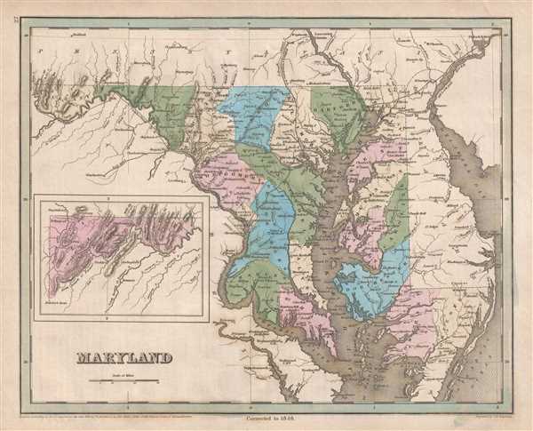
1846 Bradford Map of Maryland
1846 (dated) $400.00
1846 Bradford Map of Maryland
Maryland-bradford-1846$187.50

Title
Maryland.
1846 (dated) 12 x 5 in (30.48 x 12.7 cm) 1 : 950400
1846 (dated) 12 x 5 in (30.48 x 12.7 cm) 1 : 950400
Description
This is an 1846 Thomas G. Bradford map of Maryland. The map depicts the region from Cumberland, Maryland to Delaware Bay and from Pennsylvania to Virginia. An inset map situated in the lower left corner illustrates the entirety of Allegany County, Maryland. As is common among maps from Bradford's A Universal Illustrated Atlas, the transportation network in Maryland is presented in detail. The Chesapeake and Ohio Canal, which Bradford calls 'a gigantic project' connected Washington, D.C. and Cumberland, Maryland, a distance of 184.5 miles. The canal was not completed until 1850, meaning that it had not yet been completed when this map was printed. Used mainly for transporting coal from the Allegheny Mountains, the canal ran along the Potomac River and provided an alternative to the difficult navigation of the river. The Baltimore and Ohio Railroad, referred to as 'a bold enterprise' by Bradford, is illustrated and labeled here. The Baltimore and Ohio was created as a way for the city of Baltimore to compete with the Erie Canal, which served New York City. The goal was to connect the port of Baltimore with the Ohio River at Wheeling, West Virginia (then part of Virginia) and was still under construction at the time of this map's printing. The B and O had reached Cumberland, Maryland in November 1842. Other railroads illustrated and labeled here include the Baltimore and Susquehanna Railroad and the Baltimore and Philadelphia Railroad.
Within the state of Maryland, individual counties are labeled and shaded different colors to allow for easy differentiation. Numerous cities, towns, and villages are labeled, both within Maryland and in the surrounding region. These cities and towns include Baltimore, Annapolis, Cumberland, Washington, D.C., Dover, and Philadelphia. Both the Delaware and Chesapeake Bays are labeled, along with the Delaware, Susquehanna, and Potomac Rivers and a host of smaller rivers and creeks.
This map was engraved by George Boynton and published in the 1846 edition of Bradford and Goodrich's A Universal Illustrated Atlas.
CartographerS
Thomas Gamaliel Bradford (1802 - 1887) was born in Boston, Massachusetts, where he worked as an assistant editor for the Encyclopedia Americana. Bradford's first major cartographic work was his revision and subsequent republishing of an important French geography by Adrian Balbi, Abrege de Geographie published in America as Atlas Designed to Illustrate the Abridgment of Universal Geography, Modern and Ancient. Afterwards Bradford revised and expanded this work into his own important contributions to American cartography, the 1838 An Illustrated Atlas Geographical, Statistical and Historical of the United States and Adjacent Countries. Bradford's cartographic work is significant as among the first to record Texas as an independent nation. In his long career as a map publisher Bradford worked with William Davis Ticknor of Boston, Freeman Hunt of New York, Charles De Silver of Philadelphia, John Hinton, George Washington Boynton, and others. We have been able to discover little of Bradford's personal life. More by this mapmaker...
George Washington Boynton (fl. c. 1830 - 1850) was a Boston based cartographer and map engraver active in the first half of the 19th century. Boynton engraved and compiled maps for numerous publishers including Thomas Bradford, Nathaniel Dearborn, Daniel Adams, and S. G. Goodrich. His most significant work is most likely his engraving of various maps for Bradford's Illustrated Atlas, Geographical, Statistical, and Historical, of the United States and the Adjacent Countries and Universal Illustrated Atlas. He also engraved for the Boston Almanac. In 1835, Boynton is listed as an employee of the Boston Bewick Company, an engraving, stereotype, and printing concern based at no. 47 Court Street, Boston. Little else is known of his life. Learn More...
Source
Bradford, T. G. and Goodrich, S. G., A Universal Illustrated Atlas, exhibiting a Geographical, Statistical, and Historical view of the World, (Boston: Charles D. Strong) 1846.
The Universal Illustrated Atlas is one of the great American atlases of the first half of the 19th century. The atlas was first published in 1838 under the imprint of Charles D. Strong. It replaced and superseded Bradford's earlier smaller format Illustrated Atlas, Geographical, Statistical, and Historical, of the United States and the Adjacent Countries. Numerous reissues of the Universal Illustrated Atlas followed until about 1848. Although there are minor variations between the editions, most contain about 50 maps, the majority of which focus on the United States. Bradford's atlases are significant for recording North America during the Republic of Texas Era. In later editions, particularly the 1846 edition, Bradford illustrates the boom in railroad construction, possibly with the idea that his maps would aid travelers in planning journeys by rail. It was compiled by Thomas Gamaliel Bradford and Samuel Griswold Goodrich with most of the plates engraved by George Washington Boynton (fl. c. 1830 - 1850). Other contributors include Thomas Gordon (1778 - 1848), Fielding Lucas Jr. (1781 - 1854), Samuel Edward Stiles (1844 - 1901), Sherman and Smith (fl. c. 1829 - 1855), and Horace Thayer (1811 - c. 1874).
Condition
Very good. Even overall toning. Blank on verso.
References
Rumsey 0089.023 (1838 edition).