This item has been sold, but you can get on the Waitlist to be notified if another example becomes available, or purchase a digital scan.
1900 British South Africa Company Map of a Rail Line in Zimbabwe (Rhodesia)
Mashonaland-bsac-1900$100.00

Title
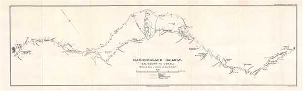
Mashonaland Railway. Salisbury to Umtali.
1900 (dated) 8.25 x 27.5 in (20.955 x 69.85 cm) 1 : 316800
1900 (dated) 8.25 x 27.5 in (20.955 x 69.85 cm) 1 : 316800
Description
This is a 1900 British South Africa Company map of the railway line between Salisbury (Harare) and Umtali (Mutare) in Rhodesia (Zimbabwe). Printed to accompany a short article in the Geographical Journal published in February 1900, this section of the railway constructed by the British South Africa Company connected Salisbury with Beira, a port on the Indian Ocean in Mozambique. The British South Africa Company (BSAC) received its Royal Charter in 1899, which had been modeled on the charter of the British East India Company. The BSAC began building the railroad in the belief that large deposits of gold and silver would be found in Mashonaland and would provide the capital to make the railway financially viable. These deposits, however, were not as prolific as originally believed. Two different routes are illustrated here. The route indicated in a solid red line is the route that was completed in 1899, while the black dotted line illustrates a proposed route that was abandoned, due to the number of large rivers it would have to cross during the rainy season.
The history of the BSAC railway is intertwined with European colonialism in sub-Saharan Africa during the beginning of the 20th century. Its main purpose was the export of mined natural resources from both Rhodesia (coal) and King Leopold II's Congo (copper). The Beira line, as it was known, carried almost all of the copper mined in the Katanga region of the Congo from 1912, when full-scale copper production began, until 1928, when a Congolese railway opened. Even after the Congolese route entered service, up to a third of Katanga copper still went to Beira.
This map was produced by the British South Africa Company printed in reduced format by the Royal Geographical Society in the Geographical Journal in February 1900.
Cartographer
Royal Geographical Society (fl. 1830 - present) is a British Society established in 1830 to promote geographical science and exploration. Originally titled the "Geographical Society of London", the RGS received its royal charter from Queen Victoria in 1859 shortly after absorbing several similar but more regional societies including the African Association, the Raleigh Club and the Palestine Association. The RGS sponsored many of the most important and exciting voyages of exploration ever undertaken, including the exploration of Charles Darwin, David Livingstone, Robert Falcon Scott, Richard F. Burton, John Speke, George Hayward, H. M Stanley, Ernest Shackleton and Sir Edmond Hillary. Today, the RGS remains a leading global sponsor of geographical and scientific studies. The Society is based in Lowther Lodge, South Kensington, London. More by this mapmaker...
Source
The Geographical Journal Vol. XV, No. 2, February 1900.
Condition
Very good. Light wear and toning along original fold lines. Blank on verso.