1904 Eldridge Nautical Chart / Map of Massachusetts Bay
MassachusettsBay-eldridge-1904$1,400.00


Title
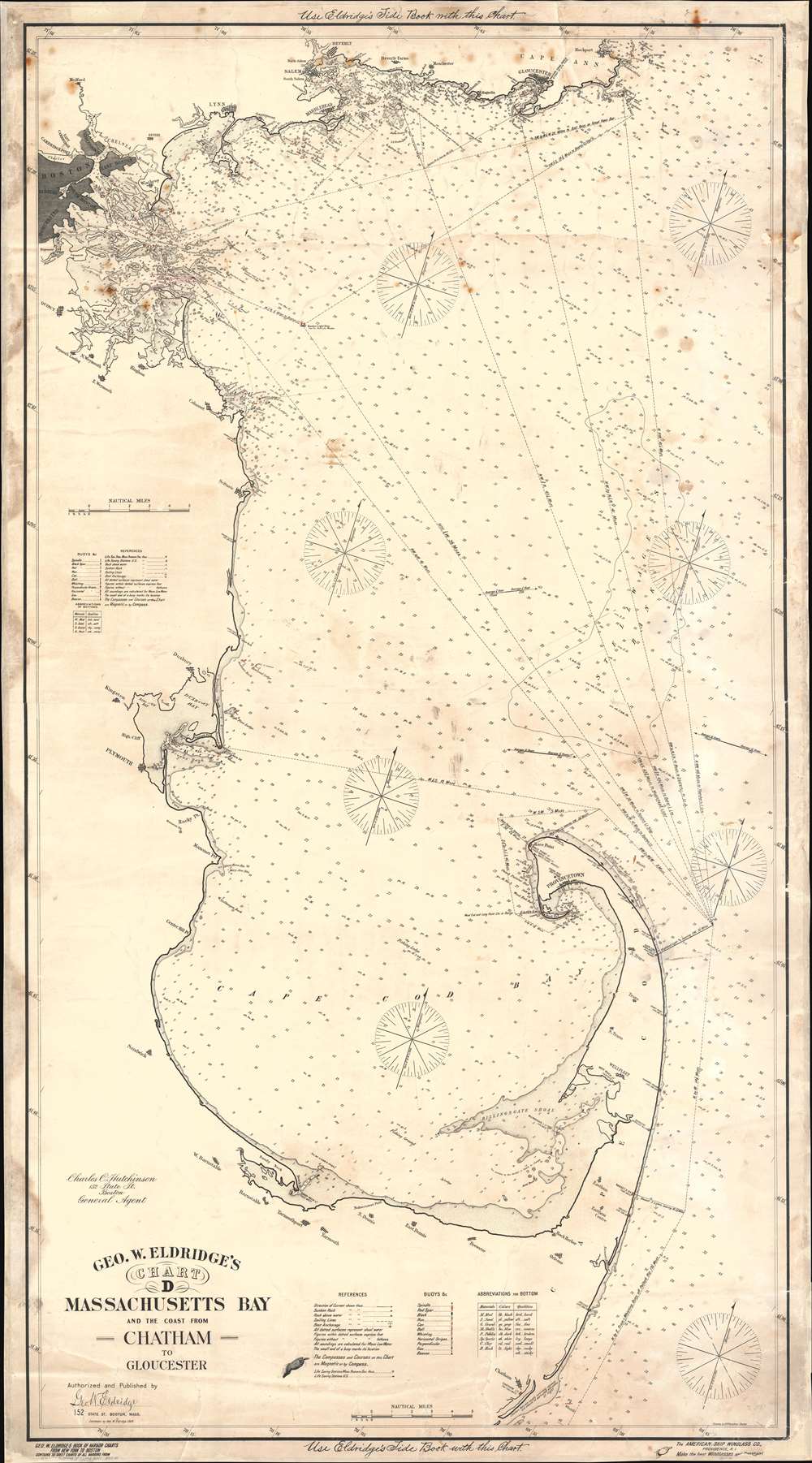
Geo. W. Eldridge's Chart D. Massachusetts Bay and the Coast from Chatham to Gloucester.
1904 (dated) 57 x 31.75 in (144.78 x 80.645 cm) 1 : 92000
1904 (dated) 57 x 31.75 in (144.78 x 80.645 cm) 1 : 92000
Description
This is a 1904 George Eldridge blueback nautical chart or maritime map of Massachusetts Bay. Coverage extends from Cape Ann south to Chatham and from Boston east to the Atlantic Ocean. Boston, Charlestown, East Boston, South Boston, Dorchester, and Roxbury appear in the upper right and are shaded gray for emphasis. The many flats and islands in the President Roads are illustrated with excellent navigational detail. Coastal lights are marked in red manuscript ink. Countless depth soundings are noted throughout. Coastal cities and towns, including Salem, Marblehead, Gloucester, Plymouth, Barnstable, Yarmouth, and Provincetown, are labeled. Notes in the top and bottom margin state that one ought to 'use Eldridge's Tide Book with the Chart'.
Blueback Charts
Blueback nautical charts began appearing in London in the late 18th century. Bluebacks, as they came to be called, were privately published large format nautical charts known for their distinctive blue paper backing. The backing, a commonly available blue manila paper traditionally used by publishers to wrap unbound pamphlets, was adopted as a practical way to reinforce the low-quality paper used by private chart publishers in an effort to cut costs. That being said, not all blueback charts are literally backed with blue paper. The earliest known blueback charts include a 1760 chart issued by Mount and Page, and a 1787 chart issued by Robert Sayer. The tradition took off in the early 19th century, when British publishers like John Hamilton Moore, Robert Blachford, James Imray, William Heather, John William Norie, Charles Wilson, David Steel, R. H. Laurie, and John Hobbs, among others, rose to dominate the chart trade. Bluebacks became so popular that the convention was embraced by chartmakers outside of England, including Americans Edmund March Blunt and George Eldridge, as well as Scandinavian, French, German, Russian, and Spanish chartmakers. Blueback charts remained popular until the late 19th century, when government subsidized organizations like the British Admiralty Hydrographic Office and the United States Coast Survey, began issuing their own superior charts on high quality paper that did not require reinforcement.Publication History and Census
This chart was drawn by A. N. Houghton and published by George W. Eldridge in 1904. Several editions were published. We have located examples in institutional collections dating as early as 1898 (which has a copyright date of 1895 suggesting even earlier editions) and as late as 1924 bearing the same title. We have been unable to locate any other examples of the 1904 edition.Cartographer
George Eldridge (November 27, 1821 - August 23, 1900) and his son George Washington Eldridge (1845 - 1914) were American makers of nautical charts and Pilot Books active in the late 19th century. George Eldridge was a Cape Cod fisherman known locally as an excellent ship's pilot. While recuperating from an injury in 1851, Eldridge drew his first nautical chart. The chart proved popular, and its success led Eldridge to pursue a career in hydrography - the science of mapping the sea with a special focus on navigation. Eldridge produced numerous subsequent maps and is credited with issuing some of the earliest accurate nautical charts of the American Atlantic coast. In time George Eldridge passed his thriving business on to his son, George Washington Eldridge, who continued to produce beautiful and practical maritime charts until 1924.Though most of Eldridge's charts were loosely based on U.S. Coast Survey work, they proved popular with navigators. The Eldridges possessed a talent, shared by both father and son, for distilling the often convoluted Coast Survey maps into practical nautical charts for the working mariner. From 1875, in addition to large format independently issued nautical charts, Eldridge also issued annual editions of Eldridge's Tide and Pilot Book and The Book of Harbor Charts. The Eldridge offices were located at 103 State St. Boston, Massachusetts. After the deaths of George and George Washington Eldridge, the firm passed into the hands of the latter's widow Sydna, and son-in-law, Wilfrid O. Wight. Wight's son and subsequent generations have continued to publish the Eldridge Tide and Pilot Book down to the present. More by this mapmaker...
Condition
Good. Full professional restoration. Mounted on linen. Exhibits areas of infill, toning, dampstaining, and soiling. Although a 'blueback' chart, the back is not in fact blue.