
1776 Des Barres Nautical Map of Mahone Bay (Mecklenburgh Bay), Nova Scotia

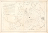
Mecklenburgh Bay.
Site of the enigmatic Treasure of Oak Island.
- Digital Map Information
- Suitable for large format printing
- Full resolution TIFF file
- ICC color profile embedded
- Delivered instantly via download link
Site of the enigmatic Treasure of Oak Island.
This is the first state of Joseph Frederick Wallet Des Barres's 1776 nautical map of Mahone Bay, Nova Scotia, titled Mecklenburgh Bay. An intricate record of the bay's islands, sheltered harbors, and navigational hazards, the chart includes Oak Island, identified as Gloucester Isle and later famed for its enduring buried-treasure legends. Published during the American Revolutionary War, the chart documents a coast where close ties to New England complicated allegiance to the British Crown.A Closer Look
The chart loosely centers on Chester and the island-filled waters of the inner bay, extending from the vicinity of the Gold River to the Aspotogan Peninsula and south to Big Tancook Island, here named Royal George Island. Carefully delineated shorelines, offshore hazards, and routes to anchorages reveal the practical demands of navigating this complex coast. In this first state, much of the land remains in outline, preceding the shaded topography introduced in later impressions. Des Barres was impressed by the bay's maritime advantages, writing, 'This Bay is full of the finest Harbours, and there are deep Passages within almost every Island in it, with convenient Anchorage for all kinds of Shipping.' His accompanying sailing directions guide mariners by the alignment of island points and visible rocks, identifying suitable anchoring depths, and warning of a ledge exposed at low water. A note on naming: Des Barres applies Mecklenburgh Bay to waters now included within Mahone Bay, while using Mahone Bay more narrowly for an inlet east of Chester. Names such as Royal George Island and Gloucester Isle further distinguish his royal nomenclature from familiar modern toponyms.Historical Context
The chart appeared at a moment of divided loyalties along Nova Scotia's South Shore. Chester grew out of the Shoreham settlement initiative of 1759, with a substantial arrival of New England settlers in 1761. These connections endured into the American Revolutionary War (1775 - 1783), when some prominent residents sympathized with the rebelling colonies. Among them was the Reverend John Seccombe, whose support for the American cause brought him before the colonial authorities in 1776 and 1777. Against this background, the chart's detailed treatment of harbors and approaches had clear practical value for British navigation along the coast southwest of Halifax.The Atlantic Neptune
Des Barres returned to London in 1774 to oversee the engraving and publication of the extraordinary body of surveys accumulated during the preceding decade. The resulting Atlantic Neptune became one of the great hydrographic achievements of the 18th century. Its charts were particularly important during the American Revolutionary War (1775 - 1783), when detailed knowledge of North American coastal waters had immediate strategic importance to the Royal Navy.The Neptune, however, was not published like a conventional atlas with a fixed complement of maps. Its charts, plans, views, and sailing directions appeared progressively and were assembled into volumes according to availability and the requirements of individual purchasers. Consequently, no standard collation exists, and surviving copies can differ substantially in both content and arrangement. The plates themselves were also repeatedly revised, creating numerous states of individual charts and views.
Publication History and Census
Frederick Wallet Des Barres surveyed this chart for the Royal Navy, likely around May 1770. It was included in some issues of the Atlantic Neptune, first issued in 1776. This is the first state of the Mecklenburgh chart (NMM #HNS36A), notable for illustrating most landforms in outline form. States break down as follows.- First state (NMM HNS36A): The present example, distinguished by most landforms being depicted in outline.
- Second state (HNS36C): Readily identifiable by its shaded topography and stippled shoals.
- Third state (HNS36D): Adds place names, including East River Bay, and more detailed depictions of settlements.
- Fourth state (HNS36G): Bears the revised date March 1, 1779, adds several place names, and is printed on J. Whatman paper. Likely the final state.
- Fifth state HNS36E): Bears the revised date April 17, 1779.
Cartographer
Joseph Frederick Wallet Des Barres (November 22, 1721 - October 24, 1824) was a Swiss-British hydrographer active with the Royal Navy in the second half of the 18th century. Des Barres was born in Switzerland. He attended the University of Basel, where he tutored under the great mathematician Daniel Bernoulli. Following his studies in Basel, Des Barres immigrated to Great Britain, where he continued his education at the Royal Military College of Woolwich. Sometime in the 1850s, Des Barres joined the American Regiment of the Royal Army as a military engineer. He was assigned to the team surveying the St. Lawrence River, where he worked with the legendary cartographer Samuel Holland and the young James Cook. Afterward, Des Barres surveyed and mapped the Maritime Provinces of New Brunswick, Nova Scotia, and Newfoundland. Des Barres's work is known for its stunning combination of accuracy and aesthetic appeal. Augustyn, in Manhattan in Maps, writes that with Des Barres, "nautical charting took an unprecedented leap toward greater precision and graphic sophistication". Upon his return to England in 1774, Des Barres was assigned to compile all of the most current cartographic information on the New World into the seminal Atlantic Neptune, which has been described as the "most splendid collection of charts, plates and views ever published" (National Maritime Museum Catalogue). Des Barres eventually returned to Canada, where he lived another 40 years as a wealthy landowner and active political figure. He died at the ripe old age of 103, one of the few centenarians of the early 19th century. Further Details...
Condition
Good. 2 sheets, joined by publisher. Several margin repairs, with 3 points of margin reinstatment, ouside of printed area. Some wear on old centerfold (where the sheets were joined by publisher). One large closed tear, from top extending about 5 inches into map - closed and stabilized.
References
National Maritime Museum, Greenwich, London, Caird Collection, #HNS36A.